Garmin Rino 520 Owner's Manual
Two-way radio & gps
Hide thumbs
Also See for Rino 520:
- Owner's manual (132 pages) ,
- Quick reference manual (2 pages) ,
- Owner's manual (72 pages)
Table of Contents
Advertisement
Quick Links
Advertisement
Table of Contents

Related Manuals for Garmin Rino 520


Summary of Contents for Garmin Rino 520
- Page 1 Rino 520/530 ® 2-way radio & GPS owner’s manual...
- Page 2 Information in this document is subject to change without notice. Garmin reserves the right to change or improve its products and to make changes in the content without obligation to notify any person or organization of such changes or improvements.
-
Page 3: Of Contents
Thank you for choosing the Garmin 530 (Radio Integrated with Navigation for the Rino ® Outdoors). To get the most from your new Rino 520 or Rino 530, read through the Quick Start Guide first, then this Owner’s Manual to understand all of the operating features. -
Page 4: Warnings And Cautions
The system is subject to changes which could affect the accuracy and performance of all GPS equipment. Although the Garmin Rino 520/530 is a precision electronic NAVigation AID (NAVAID), any NAVAID can be misused or misinterpreted and, therefore, become unsafe. - Page 5 IMPORTANT: READ THIS INFORMATION BEFORE USING YOUR RINO: Exposure to Radio Frequency Signals—Your wireless handheld radio is a low power radio transmitter and receiver. When it is on, it receives and also sends out radio frequency (RF) signals. In August 1996, The Federal Communications Commissions (FCC) adopted RF exposure guidelines with safety levels for handheld wireless radios.
- Page 6 the pacemaker to minimize the potential for interference, and should turn the radio off immediately if you have any reason to suspect that interference is taking place. Hearing Aids—Some digital wireless radios may interfere with some hearing aids. In the event of such interference, you may want to consult your hearing aid manufacturer to discuss alternatives.
- Page 7 California’s Proposition 65. If you have any questions or would like additional information, please refer to our Web site at http://www.garmin.com/prop65. Because the Garmin Rino 520/530 can be used for vehicular navigation, important safety considerations must be followed. Please read and observe the following instructions.
-
Page 8: Table Of Contents
Introduction..i Getting.to.Know.Your.Rino.520/530..1 Front.of.the.Rino.520/530... 2 Back.of.the.Rino.520/530... 3 Main.Display.Pages..4 Operating.the.Rino.520/530... 5 Status.Bar.Overview... 6 Unit.Operation..7 Radio.Page..7 Initializing the Rino 520/530 ... 7 Using Name and Symbol Fields ... 8 Setting the Channel and Code ... 10 Adjusting the Volume and Squelch Level: ... - Page 9 Satellite.Page... 43 Sky View Graphic ... 43 WAAS ... 44 Satellite Strength ... 44 Satellite Page Options ... 45 Trip.Computer.Page... 47 Trip Computer Page Options ... 47 Waypoints...48 Mark Waypoint Page ... 48 Creating Waypoints... 49 Averaging a Waypoint... 50 Projecting a Waypoint ...
- Page 10 LORAN TD Format ... 81 Heading Setup Page ... 83 Calibration Setup Page ... 83 Altimeter Setup ... 84 Welcome Page Setup ... 84 Interface Setup Page ... 85 Proximity.Waypoints... 87 Calendar...88 Alarm.Clock... 90 Calculator..91 Stopwatch... 92 Sun.&.Moon... 93 Hunt.&.Fish...
-
Page 11: Getting.to.know.your.rino.520/530
Some of the mapping options that are compatible with the Rino 520/530 include City Select, MetroGuide, Topo, Fishing Hot Spots, and BlueChart local dealer or the Garmin Web site (www.garmin.com) for a complete listing of MapSource products. The Rino 520/530 is waterproof to IPX7 standards and is designed for rugged use. -
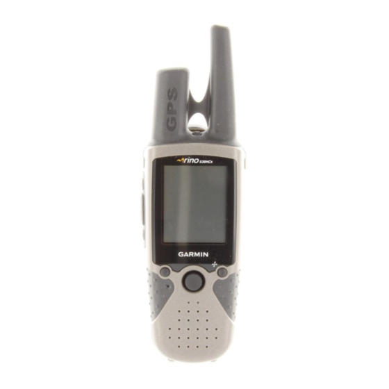
Page 12: Front.of.the.rino.520/530
Power button: • Press and hold to turn the unit On/Off • Press to adjust contrast and backlighting Call button: • Press to send out Call Tone • Sends position when released (if enabled) Talk button: • Press and hold to talk •... -
Page 13: Back.of.the.rino.520/530
Back.of.the.Rino.520/530 2-way FRS/GMRS Antenna Mini USB Port with Weather Cap Headset Connector with Weather Cap Battery Charger Contacts Lower - Wrist Strap Attachment Point Rino 520/530 Owner’s Manual ® GPS Antenna Upper - Wrist Strap Attachment Point Belt Clip/Bike/Auto Mount Connector Battery Pack Locking D-Ring Lithium-Ion Battery Pack .Lithium-Ion.Battery.Information... -
Page 14: Main.display.pages
ettIng tarted Main.Display.Pages All of the information you need to operate the Rino 520/530 can be found on five default main pages (four for the Rino 520). Simply press and release the Page/Quit button to cycle through the Radio Page, Map Page, Active Route Page*, Compass Page, Altimeter Page (Rino 530 only), and Main Menu Page. -
Page 15: Operating.the.rino.520/530
Operating.the.Rino.520/530 For best results, you should initialize the GPS receiver in your Rino 520/530 unit before you use it the first time. page 7 for instructions on initializing the unit. The compass and altimeter contained in the Rino 530 should also be calibrated. -
Page 16: Status.bar.overview
Status.Bar.Overview As you move around any of the Main Pages, the current page’s title briefly displays (3 seconds) and then is replaced by the Status Bar. The Status Bar displays current settings and operational icons and contains the Main Page and Page Option Menu The available icons are: Battery Level... -
Page 17: Unit.operation
This page provides the user interface for FRS (Family Radio Service) and GMRS (General Mobile Radio Service) radio operations. Garmin Rino units work with third party FRS/GMRS radios using standard FRS/GMRS frequencies. To take advantage of all of the Rino features, communication with other Rinos is necessary. -
Page 18: Using Name And Symbol Fields
To.initialize.the.unit: 1. Take the Rino 520/530 outside where there is an unobstructed view of the sky and turn it on. 2. The unit begins to search for satellite signals. A Satellite Signal graph is displayed on the Radio page or you can get more detailed information by accessing the Satellite Page from the Main Menu. - Page 19 Entering a name with the on-screen keyboard 4. When you have entered your new name, use the Thumb.Stick to highlight OK and then press the Thumb.Stick In. To.change.the.user.symbol: 1. Using the Thumb.Stick, highlight the face symbol on the left of the Name field. Press the Thumb. Stick In to show a list of available face icons.
-
Page 20: Setting The Channel And Code
To communicate with other Rino and FRS/GMRS users, you must be on the same channel and code. Garmin Rino units work with 3rd party FRS/ GMRS radios, provided the other radios use standard FRS/GMRS frequencies. A chart of Rino frequencies may be found in the “Appendix.”... -
Page 21: Adjusting The Volume And Squelch Level
Setting the code to 0 (code off) allows you to hear all activity on the selected channel, but you must be set to the same code as the other person(s) to transmit back. See the “Appendix” for a table listing all of the 38 Codes and their frequencies. -
Page 22: Scanning And Monitoring
Scanning.and.Monitoring The Scan option allows you to scan through the available channels for activity. As the unit scans and detects activity on a channel, it pauses on that channel/code for a few seconds, then continues scanning. If you transmit at that time you will be on that channel. When the Rino 520/530 is scanning and it receives an incoming signal, the Rino 520/530 automatically decodes the Code used by the incoming signal. -
Page 23: Radio Page Option Menu
The Code field is blank when the unit is scanning or monitoring channels until a signal is received and it pauses. To.set.up.a.Scanlist: 1. Using the Thumb Stick, highlight the Option.Menu button and press In. Highlight Setup.Scanlist and press the Thumb.Stick In. 2. -
Page 24: Setup Radio
Setup Radio The Setup Radio option displays the Radio Setup Page. This page determines how the radio functions and enables you to adjust the radio operation to your needs. The following options are available: Setup Radio Page Send Location—Enables/disables the peer-to-peer positioning feature. - Page 25 Weather Alert—When Weather Alert is enabled (See Weather Radio section), the receiver is set to look for weather alert tones either only on the current channel or on all channels . Headset Type—Allows you to choose which accessory headset or microphone you are using with the unit, or have the unit automatically detect the type.
-
Page 26: Setup Tones
Setup Tones Call Tone—When the Call button is pressed, an attention tone is transmitted. This option allows you to choose one of 10 tones. Roger Tone—When the Talk button is released, a tone is sent to signify the end of the transmission. This option allows you to choose one of four tones, or set the tone to Off. -
Page 27: Use Weather Radio
Use Weather Radio Available for the Rino 530 only, the Weather Radio provides a constant update of the weather conditions. The Weather Alert feature further enhances the Weather Radio by automatically detecting any weather alert tones if you are not actively transmitting or receiving with the radio. To access the Weather Radio, select the Weather button and press the Thumb Stick In or select the Radio Page Option Menu button. -
Page 28: Turn Radio/Gps On/Off
When a Weather Alert tone is detected, the Rino 520/530 automatically turns on the Weather Radio and broadcasts the Weather Alert if you are not actively transmitting or receiving on the radio. The volume changes to 3/4 the maximum when a Weather Alert is broadcast. Select Disable Weather Alert to turn off this feature. - Page 29 Radio.Page.Status.Indicators The Radio Page status bar displays icons and the status window displays messages and icons to describe current operating conditions, depending on what you are doing. See below for explaination of messages and icons. Message. A signal is being received, but doesn’t match the code. The 2-way Radio is turned Off FRS Channel is selected and You are receiving a transmission on the...
-
Page 30: Using.the.rino.520/530.Radio.features
Using.the.Rino.520/530.Radio. Features Your Rino 520/530 unit provides many features to enhance your radio experience, such as transmitting your location or any location and receiving contact information. This section reviews some of the advanced radio features. Refer to the “Features” section for information on all of the features of the Rino 520/530. - Page 31 The Rino 520/530 can manage up to 50 contacts at any time. Each time you receive a signal from a contact, your map is updated showing their new position. A Track Log of their movement is created and shown on your map (see the “Track Logs”...
- Page 32 To.review.a.contact.and.contact.details: 1. From the Map Page, highlight the desired contact on the Contact Bar and press the Thumb.Stick In. As you highlight the contacts on the Contact Bar, the Map page centers the map on that contact and display its name, direction and distance near the top of the screen.
-
Page 33: Sending A Location
Sending.a.Location Another feature is the ability to send a specific location to other Rino users. This comes in handy when you are trying to round-up the group or you just want to meet at a specific location. You may send any point found from the Find menu. -
Page 34: Map.page
The map can display a higher level of detail than the basemap provided with the unit (i.e. residential streets, parks, etc.), if Garmin MapSource data has been downloaded to the unit using a CD-ROM mapping program. When using MapSource data, the word “mapsource”... - Page 35 To.view.a.Contact.from.the.Map.Page: 1. Highlight the Contact icon using the Thumb. Stick. As you highlight the contacts on the Contact Bar, the Map page centers the map on that contact and displays its name, direction, and distance near the top of the screen. 2.
-
Page 36: Map
Map.Page.Options Map Page options allow a variety of operating and custom features for your Rino 520/530. The Map Page options are: Map Page Option Menu. Pan Map—Allows you to move the Panning Arrow (Map Pointer) about on the map. Refer to the “Using the Pan Map Option”... -
Page 37: Using The Pan Map Option
Using.the.Pan.Map.Option The Map Page pan function allows you to display an arrow used to point at and identify items on the map, and to move the map in order to view areas beyond the current viewing area on the display. The map panning function is activated from the Option Menu on the Map Page. -
Page 38: Programming The Data Fields
Programming.the.Data.Fields Select Show... Data Fields to view from two, three, or four optional Data Fields at the top of the screen that can be programmed to provide a variety of travel and navigation information. A list of the choices is shown to the right. -
Page 39: Setting Up The Map
Setting.up.the.Map The Setup Map option displays the five Map Setup Pages, each accessed by an on-screen button. Sub-Page Buttons Setup Items To.use.Map.Setup.options: 1. Select Setup.Map from the Options Menu and then press the Thumb.Stick In to display the Map Setup Page. 2. -
Page 40: General Setup
General Setup Orientation—Track Up or North Up; fixes the top of the map display to the current track heading or to a north heading. Below—Sets the map scale at which Track Up displays. Above that scale the map reverts to North Up. Auto Zoom—On or Off;... -
Page 41: Measuring Distance
Text Setup Map Points, user Waypoints, Street Label, and Land Cover—None, Small, Medium, or Large; control the screen size of the name. Map Information Setup Show—Check box; check mark determines if map data is used or not. Option Menu allows you to choose to show all, show none, or show specific MapSource Data. -
Page 42: Compass.page
Compass.Page The Compass Page provides active guidance with a rotating compass ring that shows your course (heading) while you are moving and a bearing pointer to indicate the current direction to your destination (bearing) relative to the course. The Data Fields at the top of the page provide you with navigation information. - Page 43 While you are navigating a route, the bearing pointer indicates the direction (a bent arrow) of the turn to the next point in the route as well as the direction to the current point when you get within 15 seconds Estimated Time of Arrival of the current point.
-
Page 44: Compass.page.options
Compass.Page.Options Sight ‘N Go—Use the Sight ‘N Go feature to locate a landmark visually and then lock in a magnetic heading to it. Rino 530 feature only. Stop Navigation/Resume Navigation—Cancels/resumes navigation (“Grayed out” or disabled unless you are navigating on a Go To, Track, or Route.) Recalculate—Recalculates the active route. -
Page 45: Using Sight 'N Go
Using.Sight.‘N.Go. Available for the Rino 530 only, this feature allows you visually locate an object and navigate to it. To.use.Sight.‘N.Go.to.navigate: 1. Use the Page button to access the Compass Page and then use the Thumb.Stick to access the Option.Menu. 2. Use the Thumb.Stick to highlight Sight.‘N.Go and press In. - Page 46 To.calibrate.the.Electronic.Compass: 1. Use the Page button to access the Compass Page. 2. Use the Thumb.Stick to highlight the Option. Menu button and press In. 3. Highlight the Calibrate.Compass option and press the Thumb.Stick In. 4. Press the Thumb.Stick In to activate the Start button and then follow on-screen directions for holding and turning the unit.
-
Page 47: Altimeter.page
Altimeter.Page. Available for the Rino 530 only, the Altimeter Page provides the current elevation, rate of ascent/descent, a profile of elevation changes over distance or time, or a profile of pressure changes over time. The Altimeter Page’s Option Menu allows you to select from a variety of display options such as plotting over time, plotting over distance, displaying the zoom ranges of measurement, viewing elevation or pressure points, and... -
Page 48: Altimeter
Altimeter.Page.Options The Altimeter Page Option Menu allows you to select the type of information and how it is to be displayed. Altimeter Page Options include: Altimeter Page Option Menu Plot Over Time/Distance—Plots the changes in elevation over a length of time or over a distance. When Plot Over Distance is selected, Plot over Time is displayed in the Option Menu (and vice versa). -
Page 49: Viewing Pressure/Elevation Plots
Viewing.Pressure/Elevation.Plots When selecting the View Elevation Plot option, you can plot a profile of elevation changes that occur as you navigate over a set distance or period of time. When you select View Pressure Plot, you can view a record of changes in the ambient or the barometric pressure for a set period of time. -
Page 50: Pan Plot
Pan.Plot The Pan Plot option allows you to scroll through the stored elevation or pressure profile and to view a single point along the profile. When the pointer is stopped at a location along the profile, the display shows the elevation, time of day and date the point was created. -
Page 51: Calibrating The Altimeter
Calibrating.the.Altimeter Because the Rino 530 relies on the barometric pressure to determine the elevation and the pressure at any given elevation can fluctuate, you can calibrate the altimeter to increase its accuracy. You must know the elevation (from a map point or other reliable data) or the pressure (calibrated to sea level - information you can obtain from the NOAA weather forecasts received on your Rino 530 or other reliable source) for your current location. -
Page 52: Main.menu.page
Main.Menu.Page The Main Menu provides access to additional Rino 520/530 feature pages. The pages listed below provide enhancements to Rino 520/530 operation. Press the Page button to cycle to the Main Menu or select it from the Main Page button at the top of each main page. Satellite Page—Provides a picture of the satellite signal tracking and tells you when the unit is ready to navigate. -
Page 53: Satellite.page
Satellite.Page The Satellite Page provides a picture of satellite signal tracking, tells you when the unit is ready for navigation, and shows your location coordinates. To.access.the.Satellite.Page: 1. Press the Page button or the Main.Page button to open the Main Menu. 2. -
Page 54: Waas
WAAS The Wide Area Augmentation System (WAAS) capability produces a more accurate position fix. When enabled (GPS set to Normal and WAAS set to Enabled through the System Setup Page, also the interface must be set to something other than RTCM mode), this feature searches for WAAS satellites near your location and then receives data for correcting differentials in the GPS satellite signals. -
Page 55: Satellite
New Location—Select this option if you have moved more than 600 hundred miles (from where you last used the unit). Restart Search—Select this option if today is not the date provided. Continue Acquiring—Select this option if no other option applies. The unit will attempt to gather GPS signals. Satellite.Page.Options Use With GPS Off—Use this option when you are indoors, your view of the sky is obstructed, or you want... - Page 56 To.select.the.Use.With.GPS.Off.option: 1. Use the Thumb.Stick to highlight the Option. Menu button at the top of the page and then press it In. 2. Use the Thumb.Stick to highlight the Use.With. GPS.Off option and then press it In. The Rino 520/530 stops tracking satellites and should not be used for navigation.
-
Page 57: Trip.computer.page
Trip.Computer.Page The Trip Computer Page by default displays up to eight different types of navigation data. Choosing Big Numbers will display three large data fields. Trip Computer Page, Trip Computer Page, Small Numbers Big Numbers Each data field is selectable and can contain one of many data information options. -
Page 58: Waypoints
Waypoints There are numerous ways to create, edit, and use waypoints. Use the Shortcut Menu, “Mark” from the Main Menu, Panning from the Map page, the “Save” option from Map Point Review page, and the “Save as Waypoint” option on the Contact Review page. The Rino 520/530 can store up to 500 waypoints. -
Page 59: Creating Waypoints
Creating.Waypoints To.create.a.waypoint.for.a. map.feature.contained.in. the.Find.feature: 1. Access the Find Menu from the Main Menu and open a categories list to select the desired map item. 2. Press In and release the Thumb.Stick to display the map item information page. 3. Highlight the Save button and press the Thumb. Stick In to save the item as a waypoint. -
Page 60: Averaging A Waypoint
Averaging.a.Waypoint Averaging a waypoint location can increase the accuracy of a waypoint at your current location by taking multiple position readings and averaging the results. To.average.a.waypoint:. Select Average.Location from the options list or the.Avg button on the Mark Waypoint page when marking a new waypoint only. - Page 61 To.delete.a.waypoint.or.contact: 1. Use the Find feature to display the point. 2. Highlight the Delete button and then press the Thumb.Stick In. Confirm the deletion. To.move.a.waypoint.by.dragging.it: 1. Use the Find Menu to display the Waypoint Page for the waypoint you want to move. 2.
-
Page 62: Find
They can be found by name or by those nearest to your current location. If you are using Rino compatible Garmin MapSource detailed mapping data, the list of Find locations is expanded to include categories for Points of Interest, Street Addresses, and Intersections. -
Page 63: Finding A Waypoint
Finding.a.Waypoint Waypoints that you have created and stored in the Rino 520/530 can be found by selecting the Waypoint option from the Find Menu. You can Find a waypoint from the list of waypoints using the Nearest current location, By Name (all waypoints in alphabetical order), or Nearest referenced location options as explained on the previous page. -
Page 64: Finding A Geocache
Finding.a.Geocache The Find Geocache feature allows you to view and navigate to geocache locations you created using your Rino or downloaded from your computer. For more information about geocaching, visit the Garmin web site www.garmin.com/outdoor/geocaching/. Rino 520/530 Owner’s Manual ®... -
Page 65: Finding A Contact
To.Find.a.geocache: 1. From the Find Menu, select the Geocache icon and press the Thumb.Stick In. 2. If you have not established a geocache list, you are presented with the Geocache setup page. Here you are asked to select symbols for geocache locations. Standard symbols for geocaching are presented along with a calendar entry option. -
Page 66: Finding A City
Finding.a.City Cities can be found by selecting the Cities option of the Find Menu, selecting the city from the list of Nearest or By Name, and then displaying the City Information Page. The City Information for the selected city displays, including the city name, the size by population, and distance from your location. -
Page 67: Finding An Exit
Finding.an.Exit You can use the Find Exit option to locate a nearby exit on an interstate highway. Exits are listed only by Nearest to your current location or a referenced location you can specify. Exit information pages provide a variety of information about services near each exit, such as rest stops, lodging, restaurants, and service stations. -
Page 68: Finding A Point Of Interest
Finding.a.Point.of.Interest You can use the Find Points of Interest option to locate a nearby restaurant, lodging, landmark, public building, park, etc. However, you must have transferred a MapSource CitySelect or MetroGuide map to the unit map database. Otherwise, this option, plus Address and Intersection options, are not displayed on the Find Menu. - Page 69 To.Find.a.point.of.interest: 1. Use the Thumb.Stick to select the desired category and then press it In to display the list for that category. 2. Use the Option.Menu button at the top of page to select from either By.Name or Nearest options. Selecting By.Name displays a keyboard allowing you to enter the characters of the name you want.
-
Page 70: Finding An Address Or Intersection
Finding.an.Address.or.Intersection You can enter a street number, choose a street name from a list and Find an address within the area of map data coverage or enter two street names and locate the intersection. To use these options, however, you must be using a MapSource product that provides this type of map data. - Page 71 To.locate.an.intersection: 1. Display the Find Menu and use the Thumb.Stick to highlight the Intersection category and press it In to display the Find.Intersection page. 2. Highlight the first Street field and then press the Thumb.Stick In to display the Street list. 3.
-
Page 72: Recent Finds
Recent.Finds You can use the Recent Finds option to locate Points of Interest, Cities, Waypoints, Contacts, Intersections and other locations you have recently retrieved. The process for Finding recent points from the Find Menu is the same as Finding a regular waypoint. To.Find.a.Last.Found.Place: 1. -
Page 73: Using Go To Navigation
Using.Go.To.Navigation The Go To is the basic function that allows you to create a route to a destination, (waypoint, city, or point of interest). Once you have accessed the Information Page for an item, use the Go To button at the bottom of the page to initiate travel, using the Map and Compass Pages for guidance. -
Page 74: Tracks.page
Tracks.Page The Rino 520/530 draws an electronic bread crumb trail on the Map Page as you travel along. This bread crumb trail is the Track Log. The Track Log contains information about points along its path, including time, and position. The Rino 520/530 uses this information to allow you to navigate using the saved track. -
Page 75: Using The Tracback Feature
Using.the.TracBack.Feature The TracBack feature allows you to return along a traveled path (or another Rino user’s path) without marking any waypoints. When you are ready to return to where you started, the Rino 520/530 takes you back by following the Track Log that you left behind. You can save a total of 20 tracks in the unit memory. - Page 76 When the track log memory field reaches 100%, the most recent track points start to overwrite the least recent if the default setting Wrap When Full remains selected on the track log setup. To avoid losing track points you want, save the Track Log when it approaches the 99% mark.
-
Page 77: Setting Up The Track Log
Setting.up.the.Track.Log You can set the track recording interval to Distance, Time, or Automatic. You can set the Track display resolution to High, Medium, Low, and Lowest. You can also use the Option Menu to delete all saved tracks. To.use.Track.Log.Setup.options: 1. Highlight the Tracks Page Setup. button on the page and press the Thumb.Stick In to display the Setup Page. -
Page 78: Routes.page
Routes.Page Route navigation allows you to create a sequence of intermediate waypoints that leads you to your final destination. The Rino 520/530 stores 20 routes, each with up to 50 waypoints. A route can be created and modified from the Routes Page, and waypoints can be added to a route from the Find Menu. -
Page 79: Editing A Route
To.add.a.Find.Menu.item.to.a.route: 1. Select an item from the Find Menu and display its Information Page. If a contact is used in a route, the route changes as the contact’s position is updated, or it may be saved as a Waypoint to serve as a stationary point. - Page 80 To.copy.the.route:. 1. From the Routes Page, select the on-screen page Option.Menu button and press the Thumb.Stick In to access the Option Menu. 2. Highlight the Copy.Route option and then press the Thumb.Stick In to copy. The copied route displays on the Routes Page and is named the same but followed by the numeral 1 (one).
- Page 81 3. With the new point highlighted, press the Thumb. Stick In to display the Information Page for the new point and then select the on-screen Use button to add it the route. Route point review options To.remove.a.point.from.the.route.list: 1. Select the point that you want to remove from the Route Waypoints List and press the Thumb.Stick 2.
-
Page 82: Adding Or Editing From The Route Map Page
Adding.or.Editing.from.the.Route.Map. Page You can use the panning arrow with the Route Map Page displayed to add or edit route waypoints. To.add.a.point.at.either.end.of.a.route: 1. Select the Route from the Routes List. Press the Thumb.Stick In to display the Route Page. 2. Highlight the on-screen Map button at the bottom of the page and press the Thumb.Stick In to display the Route Map Page. -
Page 83: Setting Up Routing Methods
To.review.or.remove.a.route.point: 1. Select the Route from the Routes List. Press the Thumb.Stick In to display the Route Page. 2. Highlight the Map button and press the Thumb. Stick In to display the route. 3. Use the Thumb.Stick to move the map panning arrow to the point you want to review and press In. -
Page 84: Navigating A Route
Navigating.a.Route A Route can be navigated using the Map Page, the Compass Page, or the Highway Page. To stop navigation, highlight the Stop Navigation option on any of the three page’s Option Menus or select Stop on the Route Page. To.navigate.a.route: 1. -
Page 85: Highway.page
Highway.Page. When you are navigating a Go To or Route, the Highway Page can guide you to your destination using navigation data fields and a graphic highway. Up to four user- selectable data fields display information such as speed, distance, time to next point on the route, etc. The Show Data Fields options are similar to the Map and Compass pages. -
Page 86: Setup.pages
Setup.Pages The Setup Pages allow you to customize the Rino 520/530 to your personal preferences. You can choose time settings, units of measure, display backlighting and timeout settings, heading measurement, interface options and system operating mode. By highlighting the icons on the Setup Menu and then pressing the Thumb Stick In, you can display the Setup Page for each of the menu items. -
Page 87: Radio Setup Page
Garmin Web site (www.garmin.com). Choose one of the GPS options other than Normal to significantly save battery power. The Battery Saver mode reduces the rate of satellite signal position updating and the GPS Off option stops satellite signal reception altogether. -
Page 88: Tones Setup Page
Backlight Intensity Level—Use a pop-up slider to adjust the brightness to your preferences. The percent set displays when you close the slider. Tones.Setup.Page This setup page allows you to select a unique tone for each of the different tone applications. (See page 16 for detailed instructions.) Page.Sequence.Setup You can add, remove, or reorder any of the Main Pages,... -
Page 89: Routing Setup Page
(See page 73 for detailed instructions.) Geocache.Setup The Geocache Page setup allows you to find and record items hidden at geographic locations. Refer to the Garmin web site for information on how to download geocache locations from the internet, www. garmin.com/outdoors/geocache/. To.setup.the.Geocache.feature: 1. -
Page 90: Time Setup Page
5. Then highlight each field to enter or select options or enter values. Time.Setup.Page You can set the time to match your geographical location. To.access.the.Time.Setup.page: 1. Press the Page/Quit button or the Main.Page button to open the Main Menu. 2. In the Main Menu, scroll down and select Setup. -
Page 91: Units Setup Page
Units.Setup.Page The Units features are best used by individuals with a working knowledge of map grids and datums. To learn more about these subjects, visit the National Imagery and Mapping Agency at http://www.nima. or inquire at your local library. To.access.the.Units.Setup. page: 1. - Page 92 For more information on Loran TDs, you may download Garmin’s Loran TD Position Format Handbook from the Garmin web site at http://www.garmin.com/support/ userManual.jsp. Map Datum—Offers a selection of nearly all map datums in common use. Every map is based on a map datum (a reference model of the earth’s shape) and is...
-
Page 93: Heading Setup Page
Heading.Setup.Page You can select the type of heading displays, North References, or magnetic variation (when set to “User”). To.access.the.Heading. Heading Setup Page Setup.page: 1. Cycle the Page/Quit button or press the Main. Page button to access the Main Menu. 2. In the Main Menu, scroll down and select Setup then select the Heading Setup page. -
Page 94: Altimeter Setup
Altimeter.Setup The Altimeter Setup Page allows you to set the Altimeter to self- calibrate each time you turn on the Rino unit in order to function as a barometer or to manually calibrate when you have accurate elevation or pressure data. To.setup.the.Altimeter: 1. -
Page 95: Interface Setup Page
NMEA devices, a DGPS beacon Interface Setup Page receiver, a personal computer, etc. To use non-Garmin data formats, you must use the RS232 to Mini USB interface cable described in the Accessories section of this manual. Refer to your Garmin Dealer or the Garmin web site (www.garmin.com) for... - Page 96 RTCM SC-104 format and simple ASCII text output of location and velocity information. None—Provides no interfacing capabilities. If Garmin DGPS or RTCM In/NMEA Out format is selected, additional fields are provided to control a Garmin differential beacon receiver directly from your unit.
-
Page 97: Proximity.waypoints
Proximity.Waypoints This feature allows you to establish waypoints that have alarm circles around at a distance you can specifiy The alarm helps you to avoid locations that are restricted or hazardous. Proximity Waypoints Page To.use.Proximity.Waypoints: 1. Cycle the Page/Quit button or press the Main. Page button to access the Main Menu. -
Page 98: Calendar
Calendar This feature provides you with a daily, weekly, or monthly calendar. The calendar allows you to view the following for any chosen location: Sunrise/Sunset time, moon phase, Hunt and Fish probabilities, and to archive waypoints for locations you have visited or want to navigate to. - Page 99 To.view.information.for.a.point: 1. In the calendar, select the desired date using the Thumb.Stick.to display the calendar date page. 2. Highlight the desired point on the page and press the Thumb.Stick In to display the information page for that point. To.remove.a.point: 1. In the calendar, select the desired date using the Thumb.Stick to display the calendar date page.
-
Page 100: Alarm.clock
Alarm.Clock Enter a time in the time field and turn the alarm on and off from the control field menu. Remember to enter alarm times in the same time format (UTC or local) you are using for your system. To.access.the.Alarm.Clock: 1. -
Page 101: Calculator
Calculator This feature provides you with all the basic functions of both of standard or scientific calculator. You can perform most calculations identified by the function symbols along the sides of the keypad and can save the results temporarily in the memory. The memory is cleared either manually or when you turn off the Rino 520/530. -
Page 102: Stopwatch
Stopwatch This feature allows you to use the unit as a stopwatch, including using it as a lap timer. You may also have the unit record the lap time based on distance. For example, if you set the lap distance to one mile, the unit records the time it takes you to travel one mile. -
Page 103: Sun.&.Moon
Sun.&.Moon This feature provides you with a graphic display of both sun and moon positioning for a certain date, time and location with times for sunrise, sunset, moonrise, and moonset. To.access.the.Sun.&.Moon.Page: 1. Cycle the Page/Quit button or press the Main. Page.button to access the Main Menu. -
Page 104: Hunt.&.Fish
Hunt.&.Fish This almanac type feature provides you with a table of predicted best times for hunting and fishing for a selected location and date. To.access.the.Hunt.&.Fish.Page: 1. Cycle the Page/Quit button or press the.Main. Page button to access the Main Menu. 2. -
Page 105: Games
Games The Games Page includes Memory Race, Geko Smak, Virtua Maze, Nibbons, Gekoids, Beast Hunt, Assimilate, Clothesline, and Waypoint Bomber. Highlight the appropriate icon and then press the Thumb Stick In to play the desired game. Brief instructions are displayed when you start each game. All players must be on the same channel/code to play games involving multiple players. -
Page 106: Nibbons
Nibbons In this GPS game, you must walk around the board collecting the flags as they appear. As you walk, your “tail” grows. You may travel anywhere on the screen but you cannot walk on your tail, or you lose a life. As an added challenge, you must also avoid the Skulls that chase after you. -
Page 107: Assimilation
Assimilation Think of this as a high-tech game of tag. In this GPS game team members select the same user symbol and then attempt to assimilate others into their team by getting within 30 feet of them and pressing the Talk button. -
Page 108: Appendix
About.FRS/GMRS.Radio FRS Radio FRS, or Family Radio Service, is a UHF radio frequency band allocated by the FCC for general public use. The operating frequency ranges from 462.5625 to 467.7125 MHz, with a maximum transmitting power of one half watt. FRS radios are small and lightweight, making them ideally suited for outdoor activities. -
Page 109: Frs Limitations
Channel scan allows your FRS radio to scan all FRS frequencies for signals. After scanning briefly to see what channels other users are on, set your FRS radios to an unused channel and enjoy less interference. For greater privacy, some FRS radios have a voice scramble feature. This feature causes your message to sound garbled to other FRS users that are not part of your group. -
Page 110: Specifications
Specifications Physical Case: Fully-gasketed, high-impact plastic alloy, waterproof to IPX7 standards (waterproof to one meter for 30 minutes) Size: 5.1” H x 2.3” W x 1.8” D; 7.5” H with antenna (13.2 x 5.8 x 4.6 cm; 19 cm with antenna) Weight: Approx. -
Page 111: Battery Life
Subject to proper user calibration. Subject to accuracy degradation to 100m 2DRMS under the U.S. DoD-imposed Selective Availability program. With optional Garmin Differential Beacon Receiver Input (such as Garmin GBR 23). 5, 5, 90 Duty Cycle - 5% receive with audio unmuted, 5%... -
Page 112: Standard.accessories.provided.with.the.unit
Bicycle Mount—Allows you to mount your Rino on a handlebar. (Not shown) Neck Lanyard—Allows you to carry the Rino around your neck. (Not shown) To obtain accessories, see your local dealer or visit the Garmin web site at www.garmin.com. Installing.Accessories... -
Page 113: Transferring.mapsource.data
520/530 Owner’s Manual ® 9. WorldMap Map data transfer requires the use of a PC, a Garmin MapSource Data Disk, and the PC Interface Cable with USB port connector supplied with this unit. Follow instructions for data transfer in the MapSource User’s Manual. - Page 114 Radio.Troubleshooting.Guide Symbol Radio not transmitting Messages not being received by others. Limited talk range. You can hear others, but they cannot hear you, or you see an incoming transmission, but nothing is heard. Message garbled. Too many unwanted conversations being heard. Interference or static.
-
Page 115: Gps.troubleshooting.guide
GPS.Troubleshooting.Guide Symptom Unit does not turn on. Unit does not turn on, even with new AA batteries. The unit turns on, then turns off. It takes more than 10 minutes to get a location fix Cannot access a WAAS system satellite after 2 to 5 minutes. -
Page 116: Frs/Gmrs Radio Frequency Chart
Radio.Frequency.Charts FRS/GMRS Radio Frequency Chart Channel Number Transmit Frequency (MHz) 462.5625 462.5875 462.6125 462.6375 462.6625 462.6875 462.7125 467.5625 467.5875 467.6125 467.6375 467.6625 467.6875 467.7125 462.5500 462.5750 462.6000 462.6250 462.6500 462.6750 462.7000 462.7250 Receive Frequency (MHz) 462.5625 GMRS Interstitial 1, FRS 1 462.5875 GMRS Interstitial 2, FRS 2 462.6125... -
Page 117: Weather Radio Frequency Chart
FRS/GMRS Radio Frequency Chart (cont.) Transmit Frequency (MHz) Channel Number 467.5500 467.5750 467.6000 467.6250 467.6500 467.6750 467.7000 467.7250 Weather Radio Frequency Chart Receive Frequency (MHz) Channel Number 162.550 WX 1 162.400 WX 2 162.475 WX 3 162.425 WX 4 162.450 WX 5 162.500 WX 6... - Page 118 CTCSS Frequency Chart for the Rino Code Number Frequency (Hz) 199.5 71.9 74.4 79.7 82.5 85.4 88.5 91.5 94.8 97.4 103.5 107.2 110.9 114.8 118.8 Code Number Frequency (Hz) 127.3 131.8 136.5 141.3 146.2 151.4 156.7 162.2 167.9 173.8 179.9 186.2 192.8 203.5...
-
Page 119: Data.field.definitions
Data.Field.Definitions The following data field options are available on the Map, Navigation, Altimeter, and Trip Computer Pages. Accuracy GPS—The estimated accuracy of the GPS signal. Ambient Pressure—Actual pressure at unit location. (Altimeter Page Only.) Ascent-Average—The average vertical distance of ascents. (Altimeter Page Only.) Ascent-Maximum—The maximum ascent rate in feet per minute. - Page 120 Odometer—A running tally of distance travelled, based upon the distance between second-by-second position readings. Off Course—The distance left or right you are from the original course (path of travel). Pointer—Indicates the direction to the next destination. Speed—Display rate of travel in miles per hour, kilometers per hour, or nautical miles per hour.
-
Page 121: Interface.information
DGPS (Differential GPS) corrections are accepted in RTCM-SC-104 version 2.0 format through the ‘Data IN’ line. The Garmin GBR 21 and GBR 23 are the recommended beacon receivers for use with the Rino 520/530. Other beacon receivers with the correct RTCM format may be used, but may not correctly display status or allow tuning control from the GPS unit. -
Page 122: Fcc.compliance.information
The Rino 520/530 does not contain any user-serviceable parts. Repairs should only be made by an authorized Garmin service center. Unauthorized repairs or modifications could result in permanent damage to the equipment and void your warranty and your authority to operate this device. -
Page 123: Fcc.licensing.information
FCC.Licensing.Information The Rino 520/530 two-way radio operates on General Mobile Radio Service (GMRS) frequencies regulated by the Federal Communications Commission (FCC) in the United States. Operation on the GMRS frequencies is subject to additional rules as specified in 47 CFR Part 95. In order to transmit on GMRS frequencies, you are required to obtain a license from the FCC. -
Page 124: Limited.warranty
Limited.Warranty This Garmin product is warranted to be free from defects in materials or workmanship for one year from the date of purchase. Within this period, Garmin will at its sole option repair or replace any components that fail in normal use. - Page 125 The Garmin Rino 520/530 has no user-serviceable parts. Should you ever encounter a problem with your unit, please take it to an authorized Garmin dealer for repairs. The Rino 520/530 is fastened shut with screws. Any attempt to open the case to change or modify the unit in any way will void your warranty and may result in permanent damage to the equipment.
-
Page 126: Software.license.agreement
BY THE TERMS AND CONDITIONS OF THE FOLLOWING SOFTWARE LICENSE AGREEMENT. PLEASE READ THIS AGREEMENT CAREFULLY. Garmin grants you a limited license to use the software embedded in this device (the “Software”) in binary executable form in the normal operation of the product. Title, ownership rights, and intellectual property rights in and to the Software remain in Garmin. -
Page 127: Index
License Finding By name 52, Contact 54, Intersection Point of Interest FRS 7, 10, Games Garmin sentences General Mobile Radio Service GMRS 1, 7, 10, 14, Goto 53, 54, 55, 56, 57, On/Off 18, Status GRI chain Headset Hunt & Fish 53, 59,... - Page 128 New Contact New Location 45, Main Display Pages NMEA 0183 Main Menu Page North Heading MapSource 1, 24, 60, North Up 30, 45, Setup Map Data 31, 60, Map Detail Operating the Rino Map Page Options Menu Options Orientation Pan Map Restore Defaults Setup Map 26, 28, Pan Map 26,...
- Page 129 Thumb Stick 2, Tones WAAS 44, Call Waterproof 1, Ring Waypoint 48, Roger Create Setup Delete Topo map Edit TracBack Move Track Weather Alert Weather Radio 17, Points Track Up 30, 45, Transmit Location 20, Zoom 25, Trip Computer Page Ranges 38, Two-way Radio 1, 98, Altimeter Page...
- Page 131 • Keep the used battery away from children. Do not disassemble, puncture, or damage the battery. • Only replace with a Garmin lithium-ion battery pack. Using another battery presents a risk of fire or explosion. To purchase a replacement battery, see your Garmin dealer or the Garmin Web site.
- Page 132 For the latest free software updates (excluding map data) throughout the life of your Garmin products, visit the Garmin web site at www.garmin.com. © Copyright 2006 Garmin Ltd. or its subsidiaries Garmin International, Inc. 1200 East 151 Street, Olathe, Kansas 66062, U.S.A.