Table of Contents
Advertisement
Quick Links
Advertisement
Table of Contents

Related Manuals for Avidyne SkyTrax 200


Summary of Contents for Avidyne SkyTrax 200
- Page 1 SkyTrax ADS-B Receiver Pilot’s Guide...
- Page 2 Revision History Revision Date of Release Reason for Release April 2019 Initial Release February 2021 Add SkyTrax 200...
-
Page 4: Table Of Contents
SkyTrax Pilot Guide TABLE OF CONTENTS System Overview ............... 1-3 EQUIPMENT DESCRIPTION ..........1-4 OVERALL SPECIFICATIONS ..........1-5 FUNCTIONAL OVERVIEW ..........1-8 SYSTEM CONFIGURATIONS ..........1-9 SkyTrax Operations ............2-10 POWER CONTROL ............2-10 CONTROL AND DISPLAY OVERVIEW ......2-10 Before Takeoff Techniques .......... -
Page 6: System Overview
SkyTrax will merge the TAS/TCAS traffic with the ADS-B traffic so that only the best source of data for each target is displayed. Interfaces will be to existing compatible displays such as Avidyne Corporation’s FlightMax EX600/EX500 Multifunction Display (MFD), Avidyne IFD4XX / IFD5XX Nav/Com/GPS/displays, and Avidyne Release 9 Integrated Cockpit system. -
Page 7: Equipment Description
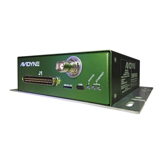
SkyTrax Pilot Guide EQUIPMENT DESCRIPTION This SkyTrax receives ADS-B messages from other UAT and/or 1090ES equipped aircraft and receives TIS-B/ADS-R/FIS-B messages from ADS-B Ground Stations. Data received by the SkyTrax Receiver is output to a compatible display device. SkyTrax Receiver The SkyTrax performs the following functions: ADS-B In (978MHz and/or 1090MHz) •... -
Page 8: Overall Specifications
SkyTrax Pilot Guide OVERALL SPECIFICATIONS This section includes the physical, electrical, performance and environmental specifications for the SkyTrax ADS-B Receiver. PHYSICAL Height 2.036 inches 7.367 inches Width (includes mounting bracket) Depth 6.812 inches Weight 1.3 lbs (excluding cables) ENVIRONMENTAL Operating temperature -55°C to +70°C Storage temperature -55°C to +85°C... - Page 9 SkyTrax Pilot Guide UAT RECEIVER PERFORMANCE This section only applies if the SkyTrax model is equipped with a 978MHz UAT receiver. Frequency 978MHz Tolerance ± 20ppm Data Rate 1.04167 Mbps Receiver Sensitivity Exceeds 90%MSR@-93dBm Equipment Class A1S (single bottom UAT antenna) 1090ES RECEIVER PERFORMANCE This section only applies if the SkyTrax model is equipped with a 1090MHz receiver.
- Page 10 SkyTrax Pilot Guide LATENCY TIMING PERFORMANCE Maximum traffic latency Traffic Latency within the ST100B/ST200 = 1.75 seconds Maximum ownship position latency within the ST100B /ST200 = 1.75 Ownship Position Latency seconds Maximum ownship position latency from the position source = 1.0 seconds Maximum latency from receiving a complete Display Latency...
-
Page 11: Functional Overview
SkyTrax Pilot Guide FUNCTIONAL OVERVIEW The Avidyne SkyTrax supports the following functions by receiving and sending information to compatible, separately approved cockpit displays. • Reception of UAT and/or 1090ES ADS-B In messages • Provide traffic information to the pilot via cockpit display. -
Page 12: System Configurations
SkyTrax Pilot Guide SYSTEM CONFIGURATIONS The SkyTrax Receiver may be configured with a GPS position source (required for traffic reception, but not required for FIS-B weather reception). The SkyTrax Receiver may also be configured with an indicator (e.g. IFD4XX, IFD5XX) to display ADS-B, ADS-R, TIS-B traffic and FIS-B weather. -
Page 13: Skytrax Operations
(Pilot’s Guides, AFMS) for the separately approved displays. This manual illustrates typical control and display features associated with the SkyTrax using Avidyne IFD4XX/IFD5XX series Nav/Com/GPS navigators as an example. For further details regarding operation of an IFD, see the Pilots Guide for that unit. -
Page 14: Ads-B Weather Display
NOTE SkyTrax Data Accuracy Avidyne does not control, review, or edit the information made available by the datalink products, and is therefore not responsible for the accuracy or timeliness of that information. -
Page 15: Weather Overlays On Map
SkyTrax Pilot Guide NOTE SkyTrax Data Intended to Aid Decision Making Weather Datalink information is meant to aid pilot planning and near-term decisions focused on avoiding areas of inclement weather that are beyond visual range or where poor visibility precludes visual acquisition of inclement weather. - Page 16 SkyTrax Pilot Guide SkyTrax Receiver Products Weather Product Possible Selections Within the Grouping Title/Category Grouping Weather Layers Rgnl Wx Rdr US Wx Radar Other Wx Rdr Storm Cells Icing* Winds/Temps Aloft Airport Reports METARs TAFs TFRs Weather Reports AIR/SIGMETs Lightning Datalink NOTE SkyTrax ADS-B Data Product Display...
-
Page 17: Ads-B Metars
SkyTrax Pilot Guide ADS-B METARS METARs are available in both text and graphical formats and represent recent surface weather observations. On the IFD, textual METARs are presented on the “Info” tab of the “FMS” page. The graphical METARs are color-coded flag symbols that summarize a recent surface weather observation and can appear as overlays on the Map and embedded in the flight plan on the Flight Plan and Nearest tabs. -
Page 18: Ads-B Airmet/Sigmet
SkyTrax Pilot Guide ADS-B AIRMET/SIGMET (US only) – These are areas where the National Weather Service has issued advisories for various types of hazardous weather. They are depicted on the Map page along with an abbreviated description of the hazard, such as “ICE” (icing), “MTN” (mountain obscuration), or “IFR”... -
Page 19: Ads-B Weather Radar
SkyTrax Pilot Guide ADS-B WEATHER RADAR The SkyTrax radar is a composite image depicting precipitation as seen by multiple ground-based weather radar sites. The image is color-coded to FAA definitions to show intensity levels and precipitation types and is overlaid on top of any other map features. - Page 20 SkyTrax Pilot Guide At large map ranges beyond 250nm from the aircraft, small areas of high-intensity radar returns may not be displayed; instead, larger areas of surrounding lower-intensity radar returns will be shown. Diagonal stripes show the SkyTrax radar data no coverage area. In normal operation, the boundary follows the outline of the Continental United States (CONUS).
-
Page 21: Ads-B Product Text
SkyTrax Pilot Guide ADS-B PRODUCT TEXT The ADS-B Product Text page shows the detailed report for TFRs, SIGMETs, and AIRMETs. Unless one of those reports has been selected on either the ADS-B TFRs page or the ADS-B AIRMET/SIGMETs page, this page will not be populated, and will instead show "No Text Selected"... -
Page 22: Ads-B Temporary Flight Restrictions (Tfrs)
SkyTrax Pilot Guide ADS-B TEMPORARY FLIGHT RESTRICTIONS (TFRS) Two types of Temporary Flight Restrictions (TFRs) are depicted – active and pending. Active TFRs are depicted as solid red lines and Pending TFRs are depicted as dashed red lines, which become solid when the TFR transition time rolls from pending to active. -
Page 23: Ads-B Unavailable Products
SkyTrax Pilot Guide ADS-B UNAVAILABLE PRODUCTS The IFD ADS-B Unavailable Products Page shows the contents of the FIS-B Product Updates Unavailable Report. That report provides notification to users of outage of individual FIS-B product updates or the entire FIS-B service. If 20 minutes has elapsed since the display last received the FIS-B Product Updates Unavailable report, the report will be removed. -
Page 24: Ifd Datalink Status Page
SkyTrax Pilot Guide IFD DATALINK STATUS PAGE This page has two distinct sections – the upper part displays the various weather products supported by the SkyTrax and subscription level with their age and receipt status; the lower part is a legend that defines the various symbols used in the datalink data depictions on the maps. -
Page 25: Ads-B Stations
SkyTrax Pilot Guide ADS-B STATIONS This page shows the ID and location of each ADS-B station from which data is being received. For each station, the percentage of data that has been received is shown as well as the look ahead range for TFRs, AIRMETs, and SIGMETs from that station. -
Page 26: Indications Of Data Age
SkyTrax Pilot Guide INDICATIONS OF DATA AGE The multiple products transmitted as part of the Broadcast Datalink service can arrive at different intervals. Two indicators at the bottom corners of each map provide an easy-to-use indication of data age. If a Datalink Icing product was selected for display via the “Wx Overlay”... - Page 27 SkyTrax Pilot Guide Data Age: RADAR and Icing Product Age Messages The following table describes the various FIS-B Weather product currency states that may be identified by an advisory message on the interfaced display: SkyTrax Message Color Valid Thru In Effect Light Green <Month, Day, Year>...
-
Page 28: Traffic Display
SkyTrax Pilot Guide TRAFFIC DISPLAY When integrated with an approved display, the display will typically show traffic information for sensed aircraft and provide visual alerting for traffic considered a threat. Approved displays will have some means of displaying status and error conditions. On an IFD, Traffic data will always be displayed as an overlay on the map and can also be selected as a datablock option on the left or right side of the display. - Page 29 SkyTrax Pilot Guide Traffic Symbol Definition TIS-B (ADS-B, ADS-R) Traffic Alert (TA) Traffic that is within the alert zone defined by the TIS-B traffic receiver and includes an arrow shaped symbol that indicate the target’s track. (yellow arrow head inside a yellow circle with a 1 minute pointer barb) TIS-B (ADS-B, ADS-R) Proximate Traffic Traffic that is not within an alert zone, but is...
- Page 30 SkyTrax Pilot Guide TAS Traffic TSAA Traffic Traffic Thumbnails For Mode-S equipped aircraft, the aircraft ID (e.g. tail number, call sign, etc) may also be displayed adjacent to the traffic symbol. Traffic Advisories (TA) will also generate a CAS message. SkyTrax Operations 2-27...
- Page 31 SkyTrax Pilot Guide Most installations will ensure the SkyTrax is in Standby or Ground mode on the ground and will automatically toggle to one of the enroute altitude modes per the table below. Traffic Altitude Mode Relative Altitude Window Below -9900’...
- Page 32 SkyTrax Pilot Guide Since TIS-B traffic data is re-transmitted data from FAA ground stations, there are a few additional possible states of the data beyond normal operating state. The non-normal TIS-B status states will be displayed in the traffic thumbnail and as CAS messages, as follows: TIS Traffic Definition...
- Page 33 SkyTrax Pilot Guide TIS Traffic Definition Thumbnail Status Either there was an antenna loss or "Maint Required" the GPS has not locked on soon enough during startup. Indicates the ground is not providing TIS-B or ADS-R services to your aircraft. The primary causes of this are: you are not in range of a ground station, OR, your aircraft is not providing qualifying ADS-B Out...
- Page 34 For those installations with a single IFD and more than one type of traffic source (e.g. TAS and a TIS-B SkyTrax100b/200) in the aircraft, Avidyne recommends wiring both traffic sources to the IFD so that the higher priority traffic overlay can display on...
-
Page 35: Synthetic Vision (Svs)
SkyTrax Pilot Guide SYNTHETIC VISION (SVS) Some displays will have the capability of showing ADS-B traffic in a synthetic vision view. In the case of an IFD550, the traffic can be shown in either egocentric or exocentric views. Any traffic in the scene will cast a shadow on the ground to help with judging distance and relative closure rate. -
Page 36: Warning-Caution-Advisory Message Bar
WARNING-CAUTION-ADVISORY MESSAGE BAR Approved displays will have a means of displaying status and error conditions. Avidyne IFD4XX/IFD5XX Navigators have a system of Caution/Advisory System (CAS) Messages that show a color coded message in the lower right corner of the display. - Page 37 SkyTrax Pilot Guide Traffic 4NM -200FT Traffic Low 4NM The above alert is just an example. After "Traffic" will be either "Low" or "High", then the distance in nautical miles. This is a traffic advisory with no bearing information. Establish visual contact with conflicting traffic in order to facilitate avoidance maneuvers as necessary.
-
Page 38: Ifd Skytrax Related Advisories
SkyTrax Pilot Guide IFD SKYTRAX RELATED ADVISORIES Broadcast Datalink receiver failure Datalink Receiver Fault Weather datalink will be unavailable Broadcast <p> Age is greater than <x> Datalink <p> minutes Stale The datalink product <p> has not been received for <x> minutes and is now considered stale. -
Page 39: Software Updates
The person performing the update must follow the provided Service Bulletin explicitly and mail/fax/email back in the completed update sheet that is part of the Service Bulletin but Avidyne does not restrict this to just Avidyne Service Centers. DATALOGS DOWNLOAD... - Page 40 SOFTWARE LICENSE WHICH CAN BE ACCESSED VIA THIS WEB ADDRESS: HTTP://WWW.AVIDYNE.COM/SUPPORT/LICENSE.ASP LIMITATION OF LEGAL RIGHTS: THE USER OF THIS EQUIPMENT AGREES TO THE TERMS AND CONDITIONS PUBLISHED BY AVIDYNE AT THIS WEB ADDRESS: HTTP://WWW.AVIDYNE.COM/SUPPORT/LEGAL-RIGHTS.ASP FCC APPROVAL AND CAUTIONS: THIS DEVICE COMPLIES WITH PART 15 OF THE FCC RULES.
- Page 41 AVIDYNE CORPORATION 710 North Drive Melbourne FL 32934 P 321 751 8520 Toll Free 800-AVIDYNE (800 284 3963) www.avidyne.com P/N 600-00334-000 Rev 01...