Furuno FA-100 Operator's Manual
Uais transponder
Hide thumbs
Also See for FA-100:
- Installation manual (58 pages) ,
- Installation manual (73 pages) ,
- Operator's manual (2 pages)
Table of Contents
Advertisement
Advertisement
Table of Contents
Troubleshooting

Related Manuals for Furuno FA-100


Summary of Contents for Furuno FA-100
- Page 1 UAIS TRANSPONDER FA-100...
- Page 2 9 - 5 2 , A s h i h a r a - c h o , N i s h i n o m i y a , J a p a n T e l e p h o n e : 0 7 9 8 - 6 5 - 2111 T e l e f a x : 0 7 9 8 - 6 5 - 4 2 0 0...
- Page 3 Continued use of the equipment can cause fire or electrical shock. Contact a FURUNO agent for service. Do not disassemble or modify the equipment. Fire, electrical shock or serious injury can result.
-
Page 4: Table Of Contents
2.5.2 Memory test ... 31 2.5.3 Keyboard test ... 31 2.5.4 LCD test... 32 2.5.5 On/off history... 32 2.5.6 GPS test ... 33 2.6 Alarm Status ... 34 2.7 Error Messages... 35 2.8 GPS Monitor ... 36 2.9 Displaying Sensor Status... 37 2.10 Restoring Default Settings... -
Page 5: Foreword
FOREWORD A Word to the Owner of the FA-100 FURUNO Electric Company thanks you for purchasing the FA-100 UAIS Transponder. We are confident you will discover why the FURUNO name has become synonymous with quality and reliability. For over 50 years FURUNO Electric Company has enjoyed an enviable reputation for quality and reliability throughout the world. - Page 6 LCD panel satisfying the IMO minimum requirements plus simple plotting modes Interfaces for radar, ECDIS, PC, LAN for future networking expansion GPS/VHF combined antenna for easy installation available CPA/TCPA alarm Built-in GPS receiver for UTC synchronization and backup position fixing...
-
Page 7: System Configuration
GSC-001 Power Supply PR-240-CE Ship’s Mains 100/110/115/200/ 220/230 VAC 1 , 50/60Hz GSC-001 Exposed to weather GVA-100 Exposed to weather FA-100 Protected from weather CB-100 Protected from weather PR-240 Protected from weather DB-1 Protected from weather Either GPS/VHF Combined Antenna... -
Page 8: Program Number
PROGRAM NUMBER Version No. MAIN 245-0001-002 245-0002-002 H8S1 245-0003-001 H8S2 245-0004-001 H8S3 245-0005-001 Date Reason for Modification Nov/2002 Nov/2002 Sep/2002 Sep/2002 Sep/2002... -
Page 9: System Overview
(in response to interrogation from a ship or authority). It is synchronized with GPS time to avoid conflict among multiple users (IMO minimum 2000 reports per minute and IEC requires 4500 reports on two channels). The VHF channels 87B and 88B are commonly used and in addition there are local AIS frequencies. - Page 10 Not all ships carry AIS The Officer of the Watch (OOW) should always be aware that other ships, and in particular leisure craft, fishing boats and warships, and some coastal shore stations including Vessel Traffic Service centers might not be fitted with AIS. The OOW should also be aware that AIS fitted on other ships as a mandatory carriage requirement might be switched off by professional judgment of the master.
-
Page 11: Specifications
SPECIFICATIONS OF THE U-AIS TRANSPONDER FA-100 The AIS shall improve the safety of navigation by assisting in the efficient navigation of ship’s, protection of the environment, and operation of Vessel Traffic Services (VTS), by the functions of collision avoidance, ships’ and cargo’s information obtaining, and traffic management. - Page 12 AD-10 format POWER SUPPLY Transponder Unit 12-24 VDC: 7-3.5 A AC/DC Power Supply Unit (PR-240, option) ENVIRONMENTAL CONDITION Ambient Temperature GPS Antenna Unit: -25°C to +70°C Other units: -15°C to +55°C Relative Humidity 95% at 40°C Waterproof (IEC 61529) Antenna Unit:...
-
Page 13: Operation
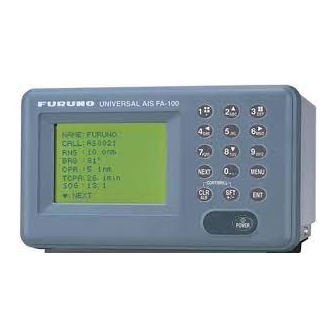
4(◄) and 6(►) CLR/ALM SFT/ +/- CLR/ALM + SFT/ +/- NEXT MENU POWER FA-100 Transponder unit Description of controls Description Alphanumeric, symbol input keys Adjust display brilliance and keyboard backlighting; scroll display. Shift the cursor left and right (pressed with [SFT/ +/-]), respectively;... -
Page 14: Turning On And Off
This takes several seconds to complete. The FA-100 should be powered while underway or at anchor. The master may switch off the AIS if he believes that the continual operation of the AIS might compromise the safety or security of his ship. -
Page 15: Adjusting Display Brilliance And Contrast
The FA-100 starts receiving data from AIS-equipped ships as soon as it is turned on, and the ships’ location on the plotter display is shown with the AIS symbol. (To learn more about the plotter display, see paragraph 1.7.) With connection of a radar or ECDIS, the AIS target symbols may be overlaid on the radar or ECDIS. -
Page 16: Menu Overview
1 OPERATION Menu Overview You can choose the functionality of the equipment through the menu. If you get lost in operation, press the [MENU] key until you return to the main menu. The complete menu tree is provided in the Appendix. 1.4.1 Menu operating procedure 1. -
Page 17: Remarks On Menu Operation
1.4.2 Remarks on menu operation Confirming entry If, after you have changed data, you pressed the [MENU] key without pressing the [ENT] key, the message shown below appears. If you want to cancel the data, press the [ENT] key. If you wish to save, use the [▼] key to choose NO, press the [ENT] key and then press the [ENT] key again. - Page 18 1 OPERATION Shifting the cursor To shift the cursor backward or forward, press [SFT/ +/-] + [◄] together to shift it backward; [SFT/ +/-] + [►] together to shift it forward. This is convenient for creating a space or using the same key consecutively. Multiple page sub-menus Some sub-menus have more than one page.
-
Page 19: Setting Up For A Voyage
4 SET TYPE&CREW 5 SET CPA/TCPA 6 SET ANTENNA POS INIT SETTING sub-menu [SET SHIP DATA] NAME : FURUNO C. SIGN : 6LCZ43B DRUGHT : 12.3 m : KEY & DISP SET SHIP DATA sub-menu [SET DESTINATION] DATE: 00/00 (DD/MM) - Page 20 1 OPERATION 10. Enter name of destination and then press the [ENT] key to register data and return to the INIT SETTINGS menu. Note: Be sure to change destination information when it changes. 11. Press the [3] key to choose SET NAV STATUS. 12.
- Page 21 16. Press the [NEXT] key to choose TYPE NO. Note: TYPE NO. is entered at installation. However, if the ship carries hazardous cargo, dangerous goods, harmful substances or marine pollutants it should be entered. 17. Use [▲], [▼], [◄], [►] to choose appropriate type number. [▲], [▼]: Increment, decrement selection number by 1.
-
Page 22: 1.6 Setting Cpa/Tcpa
1 OPERATION 20. Press the [ENT] key to save settings. 1.6 Setting CPA/TCPA Set the CPA (Closest Point of Approach and TCPA (Time to Closest Point of Approach) of AIS targets for which you want to be alerted to targets close to own ship. -
Page 23: Plotter Display
Note 2: When a target’s CPA and TCPA are lower than set in paragraph 1.6, the target flashes and the audio alarm sounds (if active). Press the [CLR/ALM] key to stop the flashing and silence the audio alarm. Take suitable measures to avoid collision. [FURUNO] SOG: 10.2 kt COG: 135.0 deg... -
Page 24: Target Data Display
1 OPERATION Target Data Display If you desire detailed information about a target, do the following: 1.8.1 Normal target data 1. Press the [MENU] key to open the menu. 2. Press the [1] key to choose TARGET DATA. (To show the DANGEROUS SHIPS display at this time, press the [SFT/ +/-] key. - Page 25 1 OPERATION Target data displays...
-
Page 26: Finding Dangerous Ship's Data
1 OPERATION 1.8.2 Finding dangerous ship’s data You can easily find dangerous ships whose CPA and TCPA are lower than the preset CPA and TCPA values set on the INIT SETTINGS menu. 1. Press the [MENU] key to open the menu. 2. -
Page 27: Own Ship's Information
5. Press the [MENU] key twice to return to the main menu. See the illustration on the next page for own static data examples. [OWN DATA] 1 OWN STATIC DATA 2 OWN DYNAMIC DATA 3 ALARM STATUS 4 SENSOR STATUS 5 INTERNAL GPS OWN DATA sub-menu 1 OPERATION... - Page 28 Navigation status description CPA (preset value) TCPA (preset value) EXT. IN: Internal GPS, OUT: External GPS Distance from bow to GPS antenna position 77 m Distance from stern to GPS antenna position 18 m Distance from port to GPS antenna position...
-
Page 29: Own Dynamic Data
1 OPERATION 1.9.2 Own dynamic data The OWN DYNAMIC DATA display shows your ship’s dynamic data, which includes time, date, ship’s position, course over ground (COG), speed over ground (SOG), rate of turn (ROT), and heading. The OOW should periodically check position, speed over ground and sensor information. -
Page 30: Messages
1 OPERATION 1.10 Messages You may send and receive messages via the VHF link, to a specified destination (MMSI) or all ships in the area. Messages can be sent to warn of safety of navigation, for example, an iceberg sighted. Routine messages are also permitted. - Page 31 5. ADDRESS TYPE is selected; use the [SFT/ +/-] key to choose address type: ADDRESS-CAST for a specific ship, or BROAD-CAST for all ships. For BROAD-CAST go to step 7. 6. For ADDRESS-CAST, press the [NEXT] key to choose “MMSI,” and then enter the MMSI of the receiving ship.
-
Page 32: Receiving Messages
1 OPERATION 1.10.2 Receiving messages When a message is received the window below appears on the display. To view the contents of the message do the following: 1. Press the [ENT] key to erase the “message received” window. 2. Press the [MENU] key to show the main menu. 3. -
Page 33: Message Logs
1.10.3 Message logs The FA-100 automatically saves five each of transmitted and received messages to their respective message logs. When a log becomes full, the oldest message in the log is automatically deleted to make room for the latest. To display a message log, do the following: 1. -
Page 34: Regional Operating Channels
1 OPERATION 1.11 Regional Operating Channels AIS operates primarily on two dedicated VHF channels, CH 2087 and CH2088. Where these channels are not available regionally, the AIS is capable of being automatically switching to designated alternate channels by means of a message from a shore facility. -
Page 35: Displaying, Editing Regional Operating Area Status
4. Press the [1] key to show the VIEW CHANNEL display. 5. Press the [MENU] key to close the display. 1.11.2 Displaying, editing regional operating area status You may display the status of regional operating areas currently memorized in the equipment. Nine of any combination of AIS message from shore-based AIS, DSC message, manual settings and commands from ECDIS or a PC may be registered and one will be a default value. - Page 36 1 OPERATION TYPE: Note: MMSI and TYPE must be set to other DEFAULT to edit. 5. Use the [▲] or [▼] key to choose file number from SELECT NO. 6. Press the [ENT] key to show details. 7. POWER is selected; press the [SFT/ +/-] key to choose power: 12.5 W or 2 8.
-
Page 37: Enabling/Disabling The Buzzer
LEFT-BOTTOM Description of RIGHT-TOP, LEFT-BOTTOM, ZONE Note: To check or edit settings on previous page, press the [NEXT] key while pressing the [SFT +/-] key. 18. Press the [ENT] key. 19. YES is selected; press the [ENT] key to register settings. (If the password entry screen is displayed, MMSI is set to DEFAULT. -
Page 38: Long Range Mode
1 OPERATION 1.13 Long Range Mode The long range mode sets how to reply to a request for own ship data from a distant station, for example, Inmarsat C station. You may reply automatically or manually. 1. Press the [MENU] key to open the menu. 2. -
Page 39: Maintenance, Troubleshooting
MAINTENANCE, TROUBLESHOOTING Maintenance Regular maintenance is necessary to maintain performance. A monthly maintenance program should be established and should at least include the items in the table below. Item Connectors Cabling Ground terminal Ground wire Transponder unit cleaning WARNING ELECTRICAL SHOCK HAZARD Do not open the equipment. -
Page 40: Resetting The Breaker
When the voltage of the battery goes below a certain level, the message BACKUP ERROR appears when turning on the power. When this occurs, contact a FURUNO agent or dealer to request replacement of the battery, at your earliest convenience. -
Page 41: Troubleshooting
On the SET MSG TYPE sub-menu, check that ADDRESS TYPE is selected to ADDRESS-CAST and MMSI is correct, before sending a message. (operating sequence: [MENU], [4], [1], [1]) Check the GPS antenna for damage. Check the GPS antenna cable and its connectors. -
Page 42: Diagnostics
2 MAINTENANCE, TROUBLESHOOTING Diagnostics The FA-100 provides diagnostic tests to check program no., memory, keyboard, LCD and built-in GPS receiver. 2.5.1 Displaying program number 1. Press the [MENU] key to open the main menu. 2. Press the [7] key to open the DIAGNOSTICS sub-menu. -
Page 43: Memory Test
2.5.2 Memory test The memory can be checked for proper operation as follows: 1. Press the [MENU] key to open the main menu. 2. Press the [7] key to open the DIAGNOSTICS sub-menu. 3. Press the [2] key to choose MEMORY TEST to test the memory. The results are shown as OK or NG (No Good). -
Page 44: Lcd Test
2 MAINTENANCE, TROUBLESHOOTING 2.5.4 LCD test The LCD can be checked for proper display as follows: 1. Press the [MENU] key to open the main menu. 2. Press the [7] key to open the DIAGNOSTICS sub-menu. 3. Press the [4] key to choose LCD TEST. The screen color automatically changes from yellowish-green to black alternately if the LCD is normal. -
Page 45: Gps Test
2.5.6 GPS test The GPS test checks the built-in GPS receiver for proper operation. 1. Press the [MENU] key to open the main menu. 2. Press the [7] key to open the DIAGNOSTICS sub-menu. 3. Press the [6] key to choose GPS TEST. -
Page 46: Alarm Status
2 MAINTENANCE, TROUBLESHOOTING Alarm Status The alarm status log shows the date and time alarms were violated. 1. Press the [MENU] key to open the main menu. 2. Press the [3] key to choose OWN DATA. 3. Press the [3] key to choose ALARM STATUS. 4. -
Page 47: Error Messages
Error Messages The FA-100 displays the following error messages to alert you to invalid data, etc.. Message BATTERY ERROR! BACKUP ERROR ENTER MMSI NO SEL. RENEW AGAIN CAN’T DISPLAY OVER LAT85° CAN’T DISPLAY INVALID DATA NO MMSI SYNCHRONISM CAN’T TAKEN... -
Page 48: Gps Monitor
DSC amplifier unless RSSI exists more than four seconds. GPS Monitor The GPS monitor display shows information about the built-in GPS receiver, including position, speed over ground, course over ground, date, time, mode and status. -
Page 49: Displaying Sensor Status
2 MAINTENANCE, TROUBLESHOOTING Displaying Sensor Status The SENSOR STATUS display monitors sensor status. 1. Press the [MENU] key. 2. Press the [3] key to choose OWN DATA. 3. Press the [4] key to choose SENSOR STATUS. [SENSOR STATUS] UTC CLOCK LOST Sensor status display 4. -
Page 50: Restoring Default Settings
You may clear all settings to start afresh with default settings. When this is done, the default options for all items in the INIT SETTING and SYSTEM SETTINGS sub-menus are restored. GPS data is also cleared; however, MMSI and IMO numbers are not cleared. -
Page 51: Appendix
2 OWN DYNAMIC DATA (Own ship latitude, longitude, SOG, COG, ROT, HDG) 3 ALARM STATUS (Displays alarm log.) 4 SENSOR STATUS 5 INTERNAL GPS (Shows position, SOG, COG, time, date, mode, reveiver status.) 4 SET MSG 1 CREATE MSG 1 SET MSG TYPE... - Page 52 APPENDIX EXT DISP ENBL ENBL ENBL ENBL 000-000-000-000 AUTO DSBL AP-2 000-000-000-000 2087 2088...
-
Page 53: Parts List
This equipment contains complex modules in which fault diagnosis and repair down to component level are not practical (IMO A.694(17)/8.3.1. Only some discrete components are used. FURUNO Electric Co., Ltd. believes identifying these components is of no value for shipboard maintenance; therefore, they are not listed in the manual. Major modules can be located on the parts location photo on page AP-4. -
Page 54: Parts Location
APPENDIX Parts Location MOT2 Board (behind) Assy. EXCT Assy. Transponder unit, front view, front panel removed Board 24P0015 Transponder unit, right side view, cover removed AP-4 PWX Assy. MPB Board (see photo below) RX1 Assy. RX2 Assy. DSC Assy. - Page 55 GPS Receiver GN-79N5A-N Transponder unit, top view, cover removed Front panel of transponder unit APPENDIX LKYZ Board 24P0026 AP-5...
- Page 56 APPENDIX Filter Assy. POWER 12-24 VDC BREAKER (PUSH-ON) AP-6 FA-100, front view GPS ANT VHF ANT AUX-1 AUX-2 AD-10 IN to JUNCTION BOX EXTRA I/O FA-100, rear view OCN Board (behind plate)
-
Page 57: Digital Interface (Iec 61162-2
Digital Interface (IEC 61162-1 Edition 2 (2000-07)/ IEC 61162-2(1998-09)) Sentence data Input sentences ABM, ACA, ACK, AIR, BBM, DTM, GBS, GGA, GLL, GNS, HDT, LRF, LRI, OSD, RMC, ROT, SSD, VBW, VSD, VTG Output sentences ABK, ACA, ALR, LRF, LR1, LR2, LR3, TXT, VDM, VDO Transmission interval ABK: With each event ACA: At RX... - Page 58 APPENDIX Serial interface I/O circuit 1. Input/Output Port SENSOR1, 2, 3, L/R, PC IO (PI), EXTRA1 (Transmission rate is selectable between 4800 bps and 38.4 Kbps.) Input( ( ( ( RD - A, B) ) ) ) lsolated IO device LTC1535 Output (TD - A, B) lsolated IO device...
- Page 59 Sentence description Input ABM - Addressed binary and safety related message This sentence provides an external application with a means to exchange data using an AIS. !--ABM,x,x,x,xxxxxxxxx,x,xx,s--s,x*hh<CR><LF> | | | | | | | | | | | | +-------- 7 | | | | +------------ 6 | | |...
- Page 60 APPENDIX ACA - AIS regional channel assignment message This sentence is used to both enter and obtain channel management information. $--ACA,x,IIII.I, a,yyyyy.yy,a,IIII.II,a,yyyyy.yy,a,x,xxxx,x,xxxx,x,x,x,a,x,hhmmss.ss*hh<CR><LF> 1. Sequence number, 0 to 9 2. Region Northeast corner latitude - N/S 3. Region Northeast corner longitude - E/W 4.
- Page 61 AIR - AIS interrogation request This sentence provides an external application with the means to initiate a request for specific ITU-R M.1371 message from distant mobile or base AIS stations. $--AIR,xxxxxxxxx,x.x,x,x.x,x,xxxxxxxxx,x.x,x*hh<CR><LF> +--------------- 6 | | +--------------------- 5 | +------------------------ 4 +--------------------------- 3 +------------------------------ 2 +------------------------------------- 1...
- Page 62 APPENDIX DTM - Datum reference Local geodetic datum to which a position location is referenced. $--DTM,ccc,a,x.x,a,x.x,a,x.x,ccc*hh<CR><LF> +------ 6 | +---------- 5 | +---+------------- 4 | +---+------------------- 3 | +------------------------- 2 +---------------------------- 1 1. Local datum W84 - WGS84 W72 - WGS72 S85 - SGS85 P90 - PE90 999 - User defined...
- Page 63 With the RAIM in the GPS receiver, the receiver can isolate faults to individual satellites and not use them in its position and velocity calculations.
- Page 64 APPENDIX GGA - Global positioning system (GPS) fix data Time, position and fix related data for a GPS receiver. $--GGA,hhmmss.ss,llll.lll,a,yyyyy.yyy,a,x,xx,x.x,x.x,M,x.x,M,x.x,xxxx*hh<CR><LF> +----+--------------------------------- 3 +---+--------------------------------------------- 2 +------------------------------------------------------------- 1 1. UTC of position (Not used.) 2. Latitude, N/S 3. Longitude, E/W 4. GPS quality indicator 5.
- Page 65 GLL - Geographic position - latitude/longitude Latitude and longitude of present vessel position, time of position fix and status. $--GLL,llll.lll,a,yyyyy.yyy,a,hhmmss.ss,A,a*hh<CR><LF> +------+----------------------- 2 +---+----------------------------------- 1 1. Latitude, N/S 2. Longitude, E/W 3. UTC of position (Not used.) 4. Status: A=data valid, V=data invalid 5.
- Page 66 APPENDIX GNS - GNSS fixed data $--GNS,hhmmss.ss,llll.lll,a,yyyyy.yyy,a,c--c,xx,x.x,x.x,x.x,x.x,x.x*hh<CR><LF> +-------+--------------------------------- 3 +---+--------------------------------------------- 2 +------------------------------------------------------------- 1 1. UTC of position (Not used.) 2. Latitude, N/S 3. Longitude, E/W 4. Mode indicator 5. Total number of satllite in use,00-99 (Not used.) 6. HDOP (Not used.) 7.
- Page 67 LRF – Long-range function This sentence is used in both long-range interrogation and long-range interrogation replies. The LRF-sentence is the second sentence of the long-range range interrogation request pair, LRI and LRF. $--LRF,x,xxxxxxxxx,c--c,c--c*hh<CR><LF> +--- 5 +------ 4 +----------- 3 +------------------- 2 +------------------------- 1 1.
- Page 68 APPENDIX OSD - Own ship data Heading. course, speed, set and drift summary. Useful for, but not limited to radar/ARPA application. $--OSD,x.x,A,x.x,a,x.x,a,x.x,x.x,a*hh<CR><LF> | | | | | | | | | +----------- 9 | | | +-------------- 8 | | | +------------------ 7 | | +--------------------- 6 | +------------------------ 5...
- Page 69 2 s and is always accompanied by RMB when a destination waypoint is active. RMC and RMB are the recommended minimum data to be provided by a GPS or TRANSIT receiver. All data fields must be provided, null fields used only when data is temporarily unavailable.
- Page 70 APPENDIX SSD - UAIS ship static data This sentence is used to enter static parameters into a shipboard AIS. The parameters in this sentence support a number of ITU-R M.1371 messages. $--SSD,c--c,c--c,xxx,xxx,xx,xx,c*hh<CR><LF> | | | | | +--- 8 | +----- 7 +------- 6 +---------- 5 +-------------- 4...
- Page 71 VSD - UAIS voyage static data $--VSD,x.x,x.x,x.x,c--c,hhmmss.ss,xx,xx,x.x,x.x*hh<CR><LF> +----------------------- 5 +------------------------------ 4 +----------------------------------- 3 +--------------------------------------- 2 +------------------------------------------- 1 1. Type of ship and cargo category, 0 to 255 2. Maximum present static draught, 0 to 25.5 Meters 3. Persons on-board, 0 to 8191 4.
- Page 72 APPENDIX Output ABK - UAIS addressed and binary broadcast acknowledgement The ABK-sentence is generated when a transaction, initiated by reception of an ABM, AIR or BBM sentence, is completed or terminated. $--ABK,xxxxxxxxx,x,x.x,x,x*hh<CR><LF> | | | | | | | +--- 6 | | +----- 5 | +------- 4 | +---------- 3...
- Page 73 LR1 - Long-range reply with destination for function request “A” The LRI sentence identifies the destination for the reply and contains the information requested by the “A” function identification character. $--LR1,x,xxxxxxxxx,xxxxxxxxx,c--c,c--c,xxxxxxxxx*hh<CR><LF> +---------------------- 4 +------------------------------ 3 +---------------------------------------- 2 +---------------------------------------------- 1 1. Sequence Number 2.
- Page 74 APPENDIX LR3- - Long-range reply for function requests “I, O, P, U and W” The LR3-sentence contains the information requested by the “I, O, P, U and W” function identification characters. $--LR3,x,xxxxxxxxx,c--c,xxxxxx,hhmmss.ss,x.x,cc,x.x,x.x,cc,x.x*hh<CR><LF> +---------------------------------------- 4 +---------------------------------------------- 3 +------------------------------------------------------ 2 +------------------------------------------------------------ 1 1.
- Page 75 VDM – VHF data-link message This sentence is used to transfer the entire contents of a received AIS message packet, as defined in ITU-R M.1371 and as received on the VHF Data Link (VDL), using the “6-bit” field type. !--VDM,x,x,x,x,s--s,x*hh<CR><LF> | | | | | | | | | +--- 7...
- Page 76 APPENDIX VHF channel list Ch No. Frequency 1001 156.05 1003 156.15 1005 156.25 156.3 1007 156.35 1018 156.9 1019 156.95 1020 1021 157.05 1022 157.1 1023 157.15 1024 157.2 1025 157.25 1026 157.3 1027 157.35 1028 157.4 1061 156.075 1063 156.175 1064 156.225...
-
Page 77: Index
LCD test ...32 memory test ...31 on/off history ...32 program no...30 Digital interface ... AP-7 Draught ...7 Dynamic data ...17 GPS monitor ...36 GPS test...33 Keyboard test...31 LCD test... 32 Long range mode ... 26 Maintenance... 27 Memory clear... 38 Memory test...