Table of Contents
Advertisement
Advertisement
Chapters
Table of Contents

Related Manuals for Garmin GPSMAP 2008


Summary of Contents for Garmin GPSMAP 2008
- Page 1 GPSMAP 2008/2108 ® owner’s manual...
- Page 2 Garmin. Garmin hereby grants permission to download a single copy of this manual onto a hard drive or other electronic storage medium...
-
Page 3: Table Of Contents
able of onTenTs Warnings �������������������������������������������������� Getting Started ����������������������������������������� Turning the Unit On or Off ������������������������ 2 Adjusting the Backlight ���������������������������� 2 Using the Keypad�������������������������������������� 3 Acquiring GPS Satellite Signals �������������� 4 Using Simulator Mode ������������������������������ 4 Viewing System Information �������������������� 5 Restoring Factory Settings ����������������������... - Page 4 able of onTenTs Using Sonar ��������������������������������������������� Understanding the Full Screen ���������������� 31 Understanding the Split Freq Screen������ 31 Understanding The Split Zoom Screen��� 32 Understanding the Temp Log Screen ����� 32 Setting Up Sonar ��������������������������������������� 33 Advanced Sonar Settings ������������������������ 34 Using Radar ���������������������������������������������...
-
Page 5: Warnings
Important Information MAP DATA INFORMATION: One of the goals of Garmin is to provide customers with the most complete and accurate cartography that is available to us at a reasonable cost. We use a combination of governmental and private data sources, which we identify in product literature and copyright messages displayed to the consumer. -
Page 6: Getting Started
TarTed Turning the Unit On or Off POWER Press and hold the key until the unit beeps and the Garmin screen appears. When the Warning screen appears, press screen. NOTE: The first time you power on your unit, you must go through a setup sequence. See for details. -
Page 7: Using The Keypad
To switch between Day and Night mode: 1. Press and release the POWER 2. Select Manual Day/Night Mode. 3. Press left or right on the ROCKER between modes. GPSMAP 2008/2108 Owner’s Manual ® Using the Keypad key. to switch POWER/BACKLIGHT—Press and hold to turn the unit on or off;... -
Page 8: Acquiring Gps Satellite Signals
When the unit acquires satellite signals, the signal strength bars at the top of the Home screen are green . When the unit loses satellite signals, the green bars disappear For more information about GPS, visit the Garmin Web site at www.garmin.com/aboutGPS. Using Simulator Mode Simulator Mode turns the GPS receiver off for use indoors or for practice. -
Page 9: Viewing System Information
To insert the SD card, press it in until it clicks. To remove the SD card, press in on the SD card. The Configure > System card pops out. eTTing Factory Settings. to restore all factory settings. Otherwise, to cancel. g2 SD card to view defailed ® Card label GPSMAP 2008/2108 TarTed... -
Page 10: Understanding The Home Screen
• sonar—access sonar information NOTE: This option is available only if you have a unit with a built-in sounder or a Garmin sonar module connected. • Chart/sonar—set up the screen to view a chart and sonar in a split screen • Where To?—access navigation features... -
Page 11: Using Charts
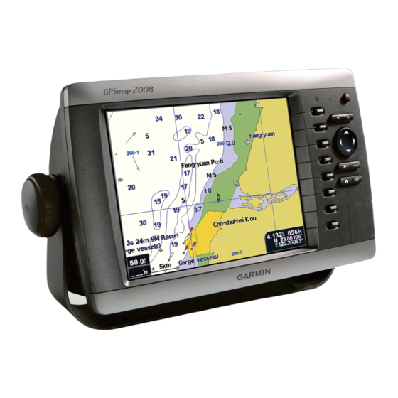
Use the navigation chart to plan your course, view map information, and as a navigational aid. GPSMAP 2008/2108 Owner’s Manual ® NOTE: For GPSMAP 2008/2108 units, you must insert a BlueChart card for your region to view detailed navigation charts. To access a navigation chart, from the Home... -
Page 12: Navigation Chart Settings
sing harTs Navigation Chart Settings To access additional settings or options for the navigation chart, press Full screen Map (show Numbers)—view the navigation or fishing chart in full-screen mode, without numbers. To view numbers, select Show Numbers to view numbers again. Full Screen Map Show Numbers Overlay Numbers—show or hide cruising, sailing, navigation, and fishing numbers on the navigation or fishing chart. -
Page 13: Zooming In And Out On The Map
Panning the Navigation Chart Use the map pointer ( ) to pan away from your current location, and scroll to other areas on the navigation chart. As you pan past the edge of the current map display, the screen scrolls forward to provide continuous map coverage. - Page 14 sing harTs 2. Select the item. If more than one item is in the area, select Review, and then select the item. Viewing Tidal Information Tidal station appears on the chart with a detailed information for users’ reference. You can view an in- depth description.
-
Page 15: Using The Split Navigation Chart
Using the Split Navigation Chart Use the Split Navigation Chart to view two different zoom levels of the Navigation Chart at the same time. Near zoom Split Navigation Chart (with a BlueChart ® g2 card) The top half of the screen is zoomed in 10 times closer than the bottom half of the screen. -
Page 16: Changing The Chart Appearance
sing harTs heading line—draws an extension from the bow of the boat in the direction of travel. • Off—turn off the heading line. • Distance—sets the distance to the end of the heading line. • Time—sets the amount of time until you reach the end of the heading line. -
Page 17: Using The Chart/Sonar Screen
Using the Chart/Sonar Screen Use the Chart/Sonar screen to view the Navigation Chart. To view a split chart/sonar screen: 1. From the Home screen, select Navigation Chart. 2. Select Navigation Chart to view both Navigation and Sonar Charts. Sonar screen Navigation/Sonar Combination GPSMAP 2008/2108 Owner’s Manual... -
Page 18: Where To
here here Use the Where To option on the Home screen to search for, and navigate to, nearby fuel, repairs, marinas, ramps, waypoints, and routes. NOTE: You have to create waypoints and routes before you can navigate to them. You can navigate to a destination using one of three methods: Go To, Route To, or Guide To. - Page 19 Waypoint Details 5. Select the marine service item to which you want to navigate. A screen containing information about the selected marine service appears. 6. Select Navigate 7. Select Go To Route 8. Follow the Tailored line on the screen to the destination.
-
Page 20: Creating And Using Waypoints
here Creating and Using Waypoints You can store up to 5000 alphanumeric waypoints with a user-defined name, symbol, depth, and water temp for each waypoint. When you create a waypoint, you can designate it as a Man Overboard. This marks the point and sets a course back to the marked location. When Man Overboard is activated, an MOB waypoint with an international Man Overboard symbol is created and the unit navigates to that point. - Page 21 To create a new waypoint: 1. On the Navigation, move the map pointer to the location you want, and press 2. Select Create Waypoint. 3. Select one of the following: • Edit Waypoint—customize the waypoint attributes. • Delete—delete the waypoint. •...
-
Page 22: Creating And Using Routes
here To move the waypoint on the navigation chart: 1. Select Edit Waypoint > Position Chart. 2. Use the ROCKER to move the waypoint to a different location, and press To view a list of all waypoints: From the Home screen, select User Data >... - Page 23 4. Press to cancel, undo the last turn, or to begin navigating the route. To create a route in another location: 1. From the Home screen, select User Data Routes > > Creating a New Route 2. Use the ROCKER to select the route’s starting point, and press 3.
- Page 24 Route used as customized border on map It is sometimes required the customized lines drawn individually on the map as warning borders/lines for cruising boats. GPSMAP 2008/2108 features customized lines (routes) that can be shown or hide individually on the map as cruising indication. You...
-
Page 25: Viewing Information
ieWinG nformaTion Use the Information screen to access information about user data, tides, currents, celestial data, and other boats. Viewing Numbers You can view and customize numerical data including depth, GPS information, and navigation information. You can customize the number of fields shown and the type of information shown in each field. You can view up to six fields of numerical information. To view the numbers screen, from the Home screen, select Information >... -
Page 26: Viewing Tide Station Information
ieWing nformaTion NOTE: The first time you use the numbers screen, you are asked to complete steps 3 and 4 for the initial setup. Viewing Tide Station Information To view tide information, select Tides from the Information screen, then select a tide station from the list. Tide station High tide curve Current tide... -
Page 27: Viewing User Data
Viewing User Data To view user data, from the Home screen, select Information > user Data. Waypoints—view a list of all saved waypoints. Routes—view a list of saved routes. Tracks—view a list of saved tracks. Data Transfer—transfer waypoints, routes, and tracks to and from an SD card. - Page 28 ieWing nformaTion DsC log—view a list of all DSC calls, sorted by most recent, sender, or by type (distress calls or position reports). • View by Time—view the seven most recent DSC calls received, sorted and displayed chronologically by time and date. Calls with identical time and date information show the same information in the list. • View by sender—view an alphanumerical list of senders.
-
Page 29: Configuring The Unit
Temperature—individually set units of measure for temperature to NOTE: You must be receiving NMEA Sonar depth data or using a Garmin sounder module to view depth and temperature information. Dist, spd, Elev—individually set the units of measure for distance, speed, and elevation readings. -
Page 30: Configuring Communications Settings
Garmin devices. • Garmin Data Transfer—the proprietary format used to upload, download, or exchange data with a computer or another Garmin unit. • Garmin Remote sonar—allows you to connect a Garmin GSD 21 or GSD 22 serially. • NMEA In/NMEA Out—supports the input or... -
Page 31: Setting Alarms
4. Select to disable, or select the NMEA output sentence. Posn. Precision—adjust the number of digits Digits, Three Digits, or Four Digits) to the right of the decimal point for transmission of NMEA output. Waypoint—select how the unit outputs waypoint or Numbers). -
Page 32: Configuring My Boat
onfigUring The Off Course—set an alarm to sound when you are off course by a specified distance. Setting System Alarms To set a system alarm, from the Home screen, select Configure > Alarms > system. Clock—set an alarm using the system clock. The unit must be on for the clock alarm to work. - Page 33 Configure > • sonar Cone Angles—when using a transducer other than the standard Garmin transducer, you can set the angle, in degrees, of the sonar cone so it is accurately depicted on the screen. NOTE: The Sonar Cone Angles setting does not...
-
Page 34: Configuring Other Boats
If you get the message again, stop the boat and make sure the speed sensor wheel is not stuck. If the wheel turns freely, check the cable connections. If you continue to get the message, contact Garmin Product Support. Configuring Other Boats To configure settings for boats other than your own, from the Home screen, select Configure boats. -
Page 35: Using Sonar
When connected to a transducer, your unit becomes a powerful fishfinder/flasher. You can connect a Garmin GSD 21 or GSD 22 sounder module to your unit to use the sonar features. NOTE: When using GSD 21, you can wire through NMEA Port 1 or CANet port whereas GSD 22 can only wire to CANet (GPSMAP 2008). With GPSMAP 2108, GSD 21 uses NMEA Port 1 while GSD 22 can only hook to network port. Understanding the Full Screen Select the Full Screen option to view a full-screen graph of the transducer’s sonar readings. -
Page 36: Understanding The Split Zoom Screen
sing onar Understanding The Split Zoom Screen Use the Split Zoom screen to view the full sonar data from the graph and a zoomed in portion on the same screen. sonar From the Home screen, select Depth, temperature, and speed Zoomed depth scale Zoom level... -
Page 37: Setting Up Sonar
Setting Up Sonar Use the Sonar Setup screen to define and adjust settings universal to all sonar screens. sonar From the Home screen, select Color scheme—choose white or blue. This affects the background on all sonar screens, but does not change the Temp Log screen. Fish symbols—set how the sonar interprets suspended targets. -
Page 38: Advanced Sonar Settings
sing onar capable), cruising, and navigation. NOTE: To show water temperature or water speed, change the setting to Auto. If the connected transducer is capable, the data is shown. Advanced Sonar Settings To adjust advanced sonar settings, press viewing a sonar screen. Range—the range of the depth scale on the right side of the screen (Auto... -
Page 39: Using Radar
(GPSMAP2108 Applicable) When you connect your chartplotter to an optional Garmin marine radar such as a GMR 404/406 or a GMR 18, you can view more information about your surroundings. The Garmin marine radar connects through the Garmin Marine Network and shares radar data with all networked chartplotters. -
Page 40: Understanding The Cruising Screen
sing adar ➌ To turn off the radar: 1. Press and release the Power chartplotter (do not hold the button, or you may shut down the chartplotter), or press 2. Select Go To Standby. Understanding the Cruising Screen Use the Cruising screen to view a full-screen image of the gathered radar information. - Page 41 gain to the default setting. Rain Cltr—adjust the gain for unwanted clutter caused by rain at close ranges. Select Right to adjust the rain clutter sensitivity. sea Cltr—adjust the gain for clutter caused by choppy sea conditions. Select steps to choose different level of sensitivity. Select left Right...
- Page 42 sing adar Antenna Size (GMR 404/406 only)—select your antenna size (4 foot or 6 foot). Motor Speed (GMR 404/406 only)—set the motor speed of your GMR 404/406 radar to Normal Speed or High Speed. High Speed increases the speed at which the antenna rotates, which increases the speed at which the screen updates.
-
Page 43: Installing The Unit
NOT CANet. Either sonar or radar information can be shown at the time when using GSD21. Both information can NOT be shown simultaneously. NOTE: When using GSD 21, please wire to the NMEA 1 In/Out port of the GPSMAP 2008 / 2108. GSD 22 should be wired to CANet (GPSMAP2008). GSD22 should be hooked to the network port (GPSMAP 2108). When using Garmin Radar and sonar modules, you will need a network expander GMS10. - Page 44 nsTalling NOTE: During a typical installation, use only the Red and Black wires. The other wires do not have to be connected for normal operation of the unit. For information on connecting to a NMEA or CANet compatible device, see To install the wiring harness: 1.
- Page 45 PIN 13 - Red (DC Positive) PIN 12 - White (CANet H) PIN 16 - Green (CANet L) PIN 18 - Blue (NMEA Out) GPSMAP 2008 Pin Assignment (VIOLET) NMEA 2 IN+ (VIOLET) NMEA 2 IN+ (GREY) NMEA 2 IN-...
- Page 46 Seven Riggs Avenue Severna Park, MD 21146 USA www.nmea.org Installing the Unit to a Garmin CANet GPSMAP 2008 is a CANet-compatible Garmin device, and can send or receive sonar information from another CANet-compatable Garmin device. Using the CANet optimizes the performance of CANet-compatible NMEA In/...
-
Page 47: Test The Installation
CANet connection provides full sonar readings, including Ultrascroll , so you can view and control ™ the same information on your compatible Garmin GPS unit(s) as you can on your compatible Garmin Sounder or Fishfinder. GPSMAP 2108 does NOT support CANet but Garmin Network. Please connect GSD 21 to NMEA Port 1 or connect GSD 22 to network port for sounder options. -
Page 48: Appendix
ppendix work properly. You cannot get a depth or distance reading when out of the water. When you place your boat in the water, check for leaks around any screw holes that were added below the water line. DO NOT leave your boat in the water for an extended period of time without checking for leaks. -
Page 49: Alarms And Messages
Power Power Source: 10-36 ± 0% VDC Usage: 7.5 Watts max at 12 VDC Fuse: AGC/3AG - 3.0 Amp NOTE:ThE RJ45 port (Garmin Network) is used for Garmin Network devices such as Radar GPSMAP 2008/2108 Owner’s Manual ® and GSD 22. The BNC coaxial cable port is to connect to GPS module for satellite positioning, of which frequency range is 1.57542 GHz. - Page 50 Can’t unlock Maps—data on data card is not unlocked for the unit. Contact your dealer or Garmin Product Support. Can’t Write user Card, Card May be Full—error reading card; remove and reinsert. Contact your dealer or Garmin Product Support if the problem persists.
- Page 51 target water temperature is 2° F (1.1° C) above or below the temperature specified by the Water Temperature Alarm. These messages appear when you enter or leave that zone. Fish Alarm—a beep sounds (if enabled) when a fish is detected. This alarm does not show a message banner. Flash Flood Warning*—a flash flood warning was issued for the area by the National Weather Service. Flood Warning*—a flood warning was issued for the area by the National Weather Service.
- Page 52 Contact your dealer or Garmin Product Support to have the unit serviced. sonar service lost—the external sonar device you were connected to has either been disconnected or the unit has lost communication with the sonar device for some other reason.
-
Page 53: Software License Agreement
THE TERMS AND CONDITIONS OF THE FOLLOWING SOFTWARE LICENSE AGREEMENT. PLEASE READ THIS AGREEMENT CAREFULLY. Garmin grants you a limited license to use the software embedded in this device (the “Software”) in binary executable form in the normal operation of the product. Title, ownership rights, and intellectual property rights in and to the Software remain in Garmin. - Page 54 Units purchased in the United States or Canada must be returned to the Garmin service center in the United Kingdom, the United States, Canada, or Taiwan for service.
- Page 55 ppendix GPSMAP 2008/2108 ® 用戶手冊(簡體中文) GPSMAP 2008/2108 用戶手冊 ®...
- Page 56 目錄 入門指南 ����������������������������������������������������54 ��������������������������������������������� 54 開啟或關閉設備 ������������������������������������������������������� 54 調節背光 ������������������������������������������������������� 55 使用鍵盤 ������������������������������������������� 56 接收GPS衛星信號 ��������������������������������������������� 56 使用模擬器模式 ������������������������������������������������ 56 查看系統信息 ������������������������������������������������ 57 恢復出廠設置 ��������������������������������������������� 57 插入和取出SD卡 ���������������������������������������������������� 58 認識主屏幕 使用導航圖 �������������������������������������������������59 ���������������������������������������������������� 59 使用導航圖 ���������������������������������������������������� 60 導航圖設置 ��������������������������������������������� 63 使用分屏導航圖...
- Page 57 使用聲納系統 ���������������������������������������������81 ������������������������������������������������ 81 認識全屏功能 ������������������������������������������������ 81 認識分頻屏幕 ������������������������������������������ 82 認識分區縮放屏幕 ������������������������������������������ 82 認識溫度日誌屏幕 ������������������������������������������������������� 83 設置聲納 ������������������������������������������������ 84 高級聲納設置 使用雷達系統 ���������������������������������������������85 產品規格 ����������������������������������������������������89 產品有害物質或元素自我宣告 ��������������������90 GPSMAP 2008/2108 用戶手冊 ®...
-
Page 58: 入門指南
入門指南 開啟或關閉設備 按住 電源鍵,直至設備發出蜂鳴聲並顯示 Garmin屏幕。在顯示警告屏幕時,按 進入主屏幕。 注意:首次啟動設備時,必須完成設置程式。細 節請參閱第81頁 報警視窗 主選單 調節背光 1.按下並鬆開 電源鍵。 2.選擇“背光”並左右推動搖杆,手動調節背 光亮度。 鍵, 背光源調整 GPSMAP 2008/2108 用戶手冊 ®... - Page 59 如需在白天和夜晚模式之間進行切換: 1.按下並鬆開 電源鍵。 2.選擇“手動日間/夜間模式”。 3.左右推動搖杆,在這兩種模式之間進行切 換。 日間模式 夜間模式 GPSMAP 2008/2108 用戶手冊 ® 使用鍵盤 電源/背光─按住該鍵可開啟或關閉設備;按下 該鍵后釋放,可調節背光及日間/夜間模式。 縮放(-/+)─按下該鍵,可調節聲納作用距 離;可在航海圖上縮放。 搖杆─沿著上、下、左、右四個方向推動,可 在菜單之間滾動、高亮顯示字段以及輸入數 據。 ─按下該鍵,標記某個航點。 ─按下該鍵,選擇高亮顯示項目並確認屏 幕消息。 電源/背光鍵 縮放鍵 搖杆(四方)鍵 (標記鍵) ( 選擇鍵 ) (菜單鍵) (主選單)
- Page 60 ─按下該鍵,可返回主選單。 ─按下該鍵,可進入附加設置和配置選項; 在屏幕提示時,按下該鍵,可返回前一個屏 幕。 接收GPS衛星信號 開啟設備時,GPS接收器必須收集衛星數據並確 定當前位置。如果設備無法確定位置,顯示初 始化位置屏幕。 當設備收到衛星信號時,主屏幕頂部的信號強 度條為綠色 。當設備失去衛星信號時,綠 色信號強度條消失 。關于GPS的詳情,請訪 問Garmin網站:www.garmin.com/aboutGPS。 使用模擬器模式 在室內使用或練習操作時,模擬器模式可關閉 GPS接收器。在模擬器模式中,設備無法跟蹤衛 星。 小心:請勿嘗試使用模擬器模式導航,因為GPS 接收器已經關閉。顯示的衛星信號強度條僅用于 模擬,並不代表實際衛星信號對強度。 如需開啟模擬器模式 1.在主屏幕中選擇配置 > 系統 > 模擬器。 2.選擇“設置”,設定速度、航跡保存和位 置。 查看系統信息 您可以查看設備的軟體版本、海圖版本和設備 的ID號。在更新系統軟體或購買附加地圖資數 據信息時,您可能需要相關信息。 在主屏幕中選擇配置 > 系統 > 系統信息。 GPSMAP 2008/2108 用戶手冊 ®...
-
Page 61: 插入和取出Sd卡
恢復出廠設置 您可以將設備恢復到原始出廠設置。 小心:該程式將刪除用戶輸入的任何信息。 如需恢復出廠設置: 1.在主屏幕中選擇配置 > 系統 > 系統信息。 2.選擇出廠設置。 3.選擇“是”,恢復出廠設置。否則,請選 擇“否”,取消操作。 插入和取出SD卡 您的設備支持安全數字(SD)卡。插入選配的 BlueChart ® g2 SD卡即可查看詳細的海圖和陸 GPSMAP 2008/2108 用戶手冊 ® 地信息。插入空白的SD卡,即可將航點、航線 和航跡等數據傳輸給其他兼容的Garmin設備或 PC機。 SD卡插槽位于設備右下角。 如需插入SD卡,按下SD卡直至聽到咔嗒聲 Card label GPSMAP 2008/2108 如需取出SD卡,按下SD卡。SD卡即可彈出。 注意:如果使用空白的新SD卡從MapSource傳輸 航點,在從PC機複製文件之前,將其插入您的 GPSMAP 2008/2108設備。該操作可完成SD卡預先 設置。 。... - Page 62 認識主屏幕 使用主屏幕訪問所有其他屏幕。 GPSMAP 2008/2108 主選單 ˙導航圖─訪問導航圖(第59頁)。 注意:在GPSMAP 2008/2108設備上,必須插入 ® 預先設置的BlueChart g2 SD卡以使用導航 圖。GPSMAP 2008/2108支持GARMIN BlueChart g2 海圖。此手冊是以BlueChart ® 示範例,BlueChart g2只有在特定國家地區適 用,詳情請洽當地GARMIN經銷商。 ˙雷達─訪問雷達信息(第85頁)。GPSMAP2108 適用。 ˙聲納─訪問聲納信息(第81頁)。 注意:只有在設備內置發聲器或連接Garmin聲納 模塊時才可使用該選項。 ˙海圖/聲納─設置在分區屏幕中查看導航圖 和聲納(第81頁)。 ˙想去何處?─訪問導航功能(第65頁)。 ˙信息─查看潮汐、洋流、天文視圖、用戶數 據以及其他船隻等信息(第72頁)。 ˙配置─訪問設備和系統設置(第75頁)。 罗盘引导辅助 GPSMAP 2008/2108在主画面中也提供了罗盘指 示功能,可帮助使用者确认目前船行的方向。 而罗盘的显示刻度单位为2度。 GPSMAP ® ® g2海圖為圖 2008/2108 用戶手冊 ®...
-
Page 63: 使用導航圖
使用導航圖 您的設備已經預先載入了一個Garmin全球海 圖。如果您有Garmin BlueChart 卡,可查看特定國家的水路詳情。 ˙導航圖─以俯視圖形式顯示預載地圖中的所 有相關導航數據,包括航標、燈 塔、電纜、測深、碼頭、潮位站。 GPSMAP 2008/2108 用戶手冊 ® 使用導航圖 使用導航圖可設計航線、查看地圖信息並協助 導航。 ® g2 海圖數據 注意:在GPSMAP 2008/2108設備上,必須插入根 據相關地區預先設置的BlueChart 看詳細的導航圖。 如需訪問導航圖,在主屏幕中選擇海圖 > 導 航海圖。 航行位置 燈塔 魚場 殘骸 縮放比例 ® SD卡,以查 浮標 ® Blue Chart g2 導航海圖 潮位站... - Page 64 導航海圖設置 如需訪問導航海圖的附加設置或選項,請按 鍵。 全屏海圖─在全屏模式下查看導航圖或漁區 圖。如需查看導航信息請按 鍵,選擇“顯示數字”,即可查 看信息。 全屏海圖 顯示導航信息 疊加數字信息─在導航圖或者漁區圖上顯示或 隱藏巡航、航行、導航和漁 區編號。 海圖設置─自定義導航圖。 航點─顯示用戶的航點,以便進行導航或者編 輯航點。 航線─創建或者選擇用戶的航道, 以便進行 導航。 GPSMAP 2008/2108 用戶手冊 ®...
- Page 65 平移導航圖 使用地圖指針( )移動當前位置,切換到導 航圖上的其他區域。如果平移範圍超過當前地 圖顯示的邊緣,屏幕向前滾動以保持地圖圖像 的連續性。位置圖示( )保持在當前位置。 在移動地圖指針時,可查看相對于當前位置的 距離和方向,地圖右下角顯示地圖指針的位置 座標。 地圖指標 船隻所在位置 如需平移地圖,可按照所需方向向上、向下、 向右或向左推動搖杆。如需停止平移,按 鍵,然后選擇“停止移動海圖”。 GPSMAP 2008/2108 用戶手冊 ® 在地圖上縮放顯示 縮放(+/-)鍵用于控制縮放比例,導航圖底部 的比例尺可顯示縮放比例。數字下的條形符號 代表地圖上的距離。 訪問附加對象信息 使用地圖指針( )查看屏幕上的地圖項目和 航點信息。 如需訪問附加對象信息: 1.在導航圖上,使用地圖指針高亮顯示某個項 .”鍵。 目,然后按下“選擇 選擇物件...
- Page 66 2.選擇項目。如果該區域中有多個項目,選 擇“檢查”,然后選擇項目。 查看潮汐信息 導航圖上顯示潮位站圖標和詳細信息,以便用 戶參考。您可以查看詳細的說明。 1.使用地圖指針( )高亮顯示潮位站圖示( .鍵。 ),然后按 2.選擇潮汐名稱(東港),即可查看詳細的潮 汐信息。 關于潮汐的更多詳情,請參見第73頁。 潮汐水位 (啟動動態潮汐時) GPSMAP 2008/2108 用戶手冊 ®...
- Page 67 使用分屏導航圖 使用分屏導航圖,同時查看不同縮放比例的導 航圖。 較大比 例圖 分屏海圖 (搭載Blue Chart g2海圖) 屏幕的上半部分比下半部分放大了10倍。縮放 (+/-)鍵可用于控制縮放比例。 按 鍵可查看附加設置。(參見第60頁)。 更改分屏設置 如需更改航海圖設置,在主屏幕中選擇海圖 > 導航海圖設置。 GPSMAP 2008/2108 用戶手冊 ® 方位─更改海圖顯示的角度: ˙北朝上─將海圖顯示的頂部設置為北方。 ˙航跡向上─將海圖顯示的頂部設置為航跡 方向。 ˙目標方位向上─設置海圖,使導航方向始終 朝上,使屏幕上航線保持垂 直方向。 航跡 較小比 例圖 船首線─從船首開始沿著行進方向繪製延長 線。 ˙關閉─關閉船首線。 船首方向線...
- Page 68 ˙距離─設置到達船首線末端的距離。 ˙時間─設置到達船首線末端所需的時間。 航海圖邊界─如果載入BlueChart 希望查看海圖範圍,則可打開航 海圖邊界。 航跡─隱藏(關閉)或顯示(開啟)航海圖上 的航跡。 外觀─自定義地圖上各種項目的顯示方式。 更改航海圖外觀 在主屏幕中選擇地圖 > 海圖設置 > 海圖顯示 風格設置。 按左鍵減 少海圖詳 細度 詳細─調節地圖上顯示的細節數據量。 水深標注─開啟測點功能並設置危險深度。 照明區─調節地圖上照明區的繪製。 符號─選擇NAVAID符號集(NOAA 或 IALA)。 ® g2地圖並 動態潮汐─開啟詳細圖標以在導航圖上顯示相 關的潮汐水位。如果該功能關閉, 導航圖上的潮位站只顯示一個圖示 ( 使用導航/聲納圖 使用航海圖/聲納屏幕查看導航圖。 如需查看分屏導航/聲納圖 1.在主屏幕中選擇海圖/聲納。 2.選擇導航地圖可同時查看導航圖和聲納圖。 按右鍵增加海 圖詳細度 聲納圖 )。 : 導航圖 導航/聲納圖 GPSMAP 2008/2108 用戶手冊 ®...
-
Page 69: 想去何處
如需訪問導航/聲納圖的附加設置或者選項,請 按 鍵。 如需調節聲納設置: 1.選擇聲納 2.選擇所需的範圍/增益/頻率設置。 導航/聲納圖設置 注意:導航/聲納圖類似于聲納屏幕,只有在使 用支持聲納設備並連接魚探器時才可使用。 GPSMAP 2008/2108 用戶手冊 ® 想去何處? 使用主屏幕中的“想去何處”選項可搜索和導 航至最近的加油站、維修站、碼頭、斜坡、航 點和航線。 注意:在導航之前,必須創建航點和航線。 可分別使用以下三種方法導航至目的地: 直達、航線與引導。 ˙直達─引導您直接到達目的地 ˙航線─從當前位置創建一條到達目的地的航 線,可在航線中增加轉向點。 使用導航功能到達目的地 可搜索和導航至最近的目的地,包括加油站、 維修站、碼頭、航點和航線。 如需開始導航: 1.在主屏幕中選擇想去何處。 2.選擇所需航點。 3.如果目的地只有一站,選擇航點/導航到/啟 動導航 4.如果有多個目的地,選擇航線。... - Page 70 想去何處 查找結果 航點信息 5.選擇希望導航的海上服務項目。屏幕顯示關 于選定海上服務的信息。 6.選擇導航到。 7.選擇啟動導航或者插入轉向點導航。 8.按照屏幕上的指示信息前往目的地。 GPSMAP 2008/2108 用戶手冊 ®...
- Page 71 如需停止導航: ,鍵,然后選擇停止導航。 按 如需按照名稱搜索目的地: 1.在主屏幕中選擇想去何處 > 按名稱查找。 2.上下推動搖杆可選擇某個數字或字符;左右 推動可移動字段。 3.按完成,可查看符合搜索條件的最近的目的 地。 GPSMAP 2008/2108 用戶手冊 ® 創建和使用航點 您最多可存儲5000個航點,每個航路點都可包 括用戶定義的名稱、符號、深度和水溫。 在創建某個航點時,可將其設置為緊急事故 點。由此可標記該點並設置返回標記位置的航 線。在啟動緊急事故點時,創建一個MOB航路點 和國際緊急事故符號,設備可導航至該點。 如需標記位置: 1.可在任何屏幕中按下 鍵。 2.選擇返回以返回航海圖,或者選擇MOB將該航 點設置為MOB。 注意:按下 該鍵只會在當前位置創建一個 航點。 如需創建一個新的航點 : 1.在導航圖上將地圖指針移至所需位置,然后 .鍵。 按 2.選擇“創建航點”。...
- Page 72 3.選擇以下某一選項: ˙編輯航點─自定義航點屬性。 ˙刪除─刪除航點。 ˙導航到─前往航點。 ˙返回─返回導航圖。 如需編輯航點 : 1.創建一個新的航點,或者在導航圖上選擇某 個航點。 2.選擇“編輯航點”。 3.選擇需要修改的航路點屬性(名稱、符號、 深度、水溫或位置)。 如需在導航圖上移動航點: 1.選擇編輯航點 > 位置 > 使用海圖。 2.使用搖杆將航路點以至不同位置,然后按 .選擇鍵。 GPSMAP 2008/2108 用戶手冊 ®...
- Page 73 如需查看所有航點列表: 在主屏幕中選擇信息 > 用戶數據 > 航點。 創建和使用航線 您最多可創建並保存50條航線,每條航線最多 250個航點。 如需從當前位置創建一條航線: 1.將地圖指針移向目的地,然后按 2.選擇導航到 > 插入轉向點。 GPSMAP 2008/2108 用戶手冊 ® 添加轉彎點於航線上 3.使用搖杆添加轉向點,然后按 該步驟,添加轉向點。 4.按 鍵取消,取消上一個轉向點,或開始 航線導航。 如需在另一個位置創建航線: 1.在主屏幕中選擇信息 > 用戶數據 > 航線 > 新航線。 鍵。 鍵。重複...
- Page 74 創建新航線 2.使用搖杆選擇航線的起點,然后按 3.使用搖杆和 鍵,增加轉向點。 4.按 鍵取消、編輯或執行航線導航。 如需編輯航線 1.在主屏幕中選擇信息 > 用戶數據 > 航線。 2.選擇需要編輯的航線。 3.選擇“編輯航線”。您可編輯航線名稱、轉 向點或刪除航線。 鍵。 如需刪除航線: 1.在主屏幕中選擇信息 > 用戶數據 > 航線。 2.選擇需要刪除的航線。 3.選擇“刪除”。 GPSMAP 2008/2108 用戶手冊 ®...
- Page 75 在地圖上自定邊界路線 在船行导航过程中,有时需要在地图上自订边 界或警告的路线,GPSMAP 2008/2108有支持自 订路线的功能,并可在进行导航,将设定的航 线单独显示或隐藏。使用者可以自己建立新航 线,或是将行径的轨迹储存为航线使用。纪录 的航线可以依照使用者的不同需求,在海图上 单独显示或隐藏自订的航线。如果要显示自订 航线,需要有已储存的航线才能显示。 GPSMAP 2008/2108 用戶手冊 ® 注意:只有当船只接收到卫星讯号以及处导航模 式时,自订路线才能单独显示。...
-
Page 76: 查看信息
查看信息 使用信息屏幕訪問關于用戶數據、潮汐、洋 流、天文數據以及其他船隻的信息。 查看航行數據 您可查看和自定義深度、GPS信息、導航信息等 數字數據。您可以自定義顯示的字段數量和每 一個字段中顯示的信息類型。您最多可查看六 個字段的數字信息。 如需查看數據屏幕,在主屏幕中選擇信息 > 數 據頁面 > 用戶自訂。 如需自定義數據屏幕: 1.在主屏幕中選擇信息 > 數據頁面 >用戶自 訂。 2.按 鍵並選擇配置。 3.選擇顯示的字段數量(3、4、5或6)。 4.選擇在每個字段中顯示的信息。 注意:首次使用數據屏幕時,系統會要求您完成 初始設置的第3步和第4步。 GPSMAP 2008/2108 用戶手冊 ®... - Page 77 查看潮位站信息 如需查看潮汐信息,在信息屏幕中選擇“潮 汐”,然后從列表中選擇某個潮位站。 • 想查看潮汐信息,選擇 顯示報告。 • 想查看潮汐圖,選擇 顯示潮汐圖。 預測潮汐信息 查看天體信息 使用天體數據屏幕,查看日月升降、月相、日 月天空圖像近似位置等天文數據。 GPSMAP 2008/2108 用戶手冊 ® 如需查看天文信息,在信息屏幕中選擇“天文 視圖”。 太陽位置 月亮位置 天文圖 預測潮汐圖 查看用戶數據 如需查看用戶數據,在主屏幕中選擇信息 > 用 戶數據。 航路點─查看所有保存的航點列表。 航線─查看保存的航線列表。 航跡─查看保存的航跡列表。 數據傳輸─通過SD卡傳輸航點、航線和航跡 清除用戶數據─刪除所有用戶航點、航線和航 按左/右鍵調整時間 月相圖 數據。 跡數據。...
- Page 78 如需通過SD卡傳輸數據: 1.將SD卡插入設備正面的SD卡插槽。(參見第 57頁。) 2.在主屏幕中選擇信息 > 用戶數據 > 數據傳 遞。 3.完成以下某一項操作: ˙選擇“保存到存儲卡”,將航點、航線和航 跡數據保存到SD卡。 ˙選擇“從存儲卡上合併”,從SD卡將數據送 到設備並與現有的GPS數據合併。 ˙選擇“由存儲卡上替換”,覆蓋設備中的數 據。 查看其他船隻 如需查看關于其他船隻的數據,在主屏幕中選 擇信息 > 其他船信息。 注意:如需查看關于其他船隻的信息,設備必須 連接到外部AIS(自動識別系統)或者DSC(數字 選擇性呼叫)設備。 AIS 列表─查看關于設備正在監控的所有船隻 的信息。AIS 列表顯示MMSI或者AIS船隻的名稱 (如果船隻正在發送廣播),並按照距離範圍 排序。距離本船最近的船隻位于列表的頂部。 GPSMAP 2008/2108 用戶手冊 ®...
-
Page 79: 配置設備
DSC日誌─查看所有DSC呼叫列表,可按照呼叫 時間、呼叫人或者呼叫類型排序(求救呼叫或 者位置報告)。 ˙按照時間順序查看─查看最近收到的7次DSC 呼叫,按照時間和日期排序並顯示。時間與 日期信息相同的呼叫在列表中顯示相同信 息。 ˙按照發送人順序查看─查看發送人的字母數 字列表。 ˙按照類型查看─查看最近收到的7次求救呼 叫或者位置報告(按照時間順序排列)。 DSC呼叫列表─查看最近收到的100次呼 叫。DSC呼叫列表可顯示某個 船隻最近發出的呼叫。如果從 同一船隻收到第二次呼叫,該 呼叫將替換呼叫列表中的第一 次呼叫。 目錄─查看所有DSC條目的列表。可按照名稱 或MMSI排序查看。您還可添加條目。 設置─開啟或關閉AIS及DSC,為本船設置安 全區。 GPSMAP 2008/2108 用戶手冊 ® 配置設備 使用配置屏幕調節設備設置。 配置系統設置 如需更改一般系統設置,在主屏幕中選擇配置 > 系統。 模擬器─開啟或者關閉模擬器模式並設置模擬 器模式選項。(如果您在初次設備設 置的過程中將設備設置為存儲演示模 式,該設置將被命名為Demo。) 語言設置─選擇屏幕顯示語言。(支持英文、 簡體中文、繁體中文及其他亞洲 語系) 蜂鳴/顯示─選擇蜂鳴器設置,使設備發出聲 響。提供三項設置:關閉、僅報 警(默認)和按鍵和報警音。選 擇顯示設置在日間或夜間模式之... - Page 80 溫度─可將溫度測量單位單獨設置為華氏度 (℉)或者攝氏度(℃)。 注意:如需查看深度和溫度信息,必須接收NMEA 聲納深度數據或者使用GARMIN聲納模塊GSD21/ GSD22。 距離、航速和海拔─單獨設置距離、航速和海 拔的測量單位。 航向─設置計算航向信息時使用的基準。 位置─更改位置讀數採用的坐標系。默認格 式為hddd mm.mmm’。如果正在使用指 定了不同位置格式的地圖或者航海圖, 只需更改位置格式。 時間─設置時間格式(12小時,24小時,或者 UTC時間格式)、時區,並說明是否使 用夏令時。 配置通信設置 如需更改通信系統設置,在主屏幕中選擇配置 > 通信。 數據端口─選擇在將設備連接到外部NMEA設 備、個人計算機或者其他Garmin設備時使用的 輸入/輸出格式。 ˙Garmin數據傳輸─使用專有格式上載、下載 或者與計算機或其他Garmin設備交換數據。 ˙Garmin外置聲納─可串列連接Garmin GSD 21或者GSD 22。 ˙NMEA輸入/NMEA輸出─支持標準NMEA 0183數 據的輸入或者輸出、DSC,提供對DPT、MTW和 VHW語句的NMEA輸入支持。 ˙NMEA高速─支持大多數AIS接收器的標準0183 數據。 ˙無─不提供任據傳輸 NMEA設置─啟用或者禁用發聲器、航線、系統 GPSMAP 2008/2108 用戶手冊 ®...
- Page 81 和Garmin NMEA設置的NMEA輸出語句。 啟用或者禁用NMEA輸出語句: 1.在主屏幕中選擇配置 > 通信 > NEMA設置。 2.選擇某項設置(發聲器、航線、系統或 Garmin)。 3.選擇一個NMEA輸出語句。 NMEA 輸入/輸出 測深語句 GPSMAP 2008/2108 用戶手冊 ® 4.選擇“關閉”以禁用或者選擇“開啟”,啟 用NMEA輸出語句。 位置精度─調節傳輸NMEA輸出數據時使用的小 數字數(兩位、三位或四位)。 航點─選擇設備輸出航點標識符(名稱或編 號)。 設置報警 可設置設備在滿足特定條件時發出聲響報警。 默認情況下,關閉所有報警。 如需設置報警: 1.在主屏幕中選擇配置 > 報警。 2.選擇報警(導航、系統、及聲納)。 3.選擇導航報警。 4.選擇移錨以啟動,然后使用搖杆指定報警信 息。...
- Page 82 設置導航報警 如需設置導航報警,在主屏幕中選擇配置 > 報警 > 導航。 移錨─設置在超過規定漂移距離時發出報警 聲。 到達時間─設置在進入目標航點指定距離或者 時間範圍內時發出報警聲。 偏航─設置在偏離行間的距離超出規定時發出 報警聲。 設置系統報警 如需設置系統報警,在主屏幕中選擇配置 > 報警 > 系統。 鬧鐘─使用系統時鐘設置報警。時鐘報警功能 按向上/向下鍵 增加/減少 只有在設備開啟時才有效。 電池─設置在電池達到用戶定義的低電壓時發 出報警聲。 GPS精度─設置在GPS位置精度低于用戶定義值 時發出報警聲。 按左/右鍵移動輸 入位數 設置聲納報警 如需設置聲納報警,在主屏幕中選擇配置 > 報 警 > 聲納。 淺水/深水報警─設置在深度低于或者超過規 水溫報警─ 設置在魚探器測量溫度與規定溫 度之間的溫差超過2℉(1.1℃) 時發出報警聲。 魚群報警─設置在設備發現符合規定符號的懸 浮目標時出報警聲。 注意:必須連接魚探器。GPSMAP2008/2108沒有 內聲納模塊,所以必須安裝GSD 21 或 GSD 22 聲納模塊以接收聲納信息。 定值時發出報警聲。 GPSMAP 2008/2108 用戶手冊...
- Page 83 小允許深度(參考航海圖深度基準)。 ˙安全高度─設置船隻從橋下安全通行的最小 高度(參考航海圖高度基準)。 吃水調整─針對龍骨深度補償表面讀數。這樣 可從龍骨底部(而不是魚探器位置)開始測量 深度。輸入正值可執行龍骨補償。對于吃水線 高度達到數英尺的大型船隻,可輸入負值以便 補償。 如需調節龍骨補償(吃水調整): 1.在主屏幕中選擇配置 > 本船信息 > 吃水調 整。 2.使用搖杆設置龍骨補償值。 3.按 鍵可確認數字。 注意:按下 該鍵可取消更改,並返回我的船 隻屏幕 GPSMAP 2008/2108 用戶手冊 ® 魚探器位于水面 魚探器位于水面 輸入(+)正值 顯示魚探器至龍骨底部之深度 魚探器位于龍骨底部 魚探器位于龍骨底部 輸入(-) 負值顯示魚探器至水面之深度 吃水調整(Keel offset) 魚探器─選擇魚探器類型(雙頻或單頻雙波 束),設置溫度源、聲納發射錐角及校準水流 速。 ˙溫度來源─設置溫度來源(魚探器或NEMA) ˙聲納發射錐角─如果使用非標準Garmin魚探 器,可設置聲納錐角的角度,以便在屏幕上 精確顯示。 ˙校準水速─設置具有量測水速的魚探器,可 使用此菜單進行校準,如果你的魚探器不具 有速度感知器,則此功能將無法使用。 注意:聲納錐角設置不會影響標準GARMIN魚探 器,而且只應校準水流速─如需使用速度魚探...
- Page 84 器,則使用該菜單進行校準。如果不使用速度魚 探器,則不會顯示該菜單。 如需校準速度魚探器: 1.在主屏幕中選擇配置 > 本船信息 > 魚探器 > 校準水速。 2.使船隻以巡航速度行駛。記錄最高速度,然 后停船。 3.高亮顯示OK,然后按 鍵。 4.使用搖杆輸入最高速度,然后按 注意:如果船隻速度不夠高,或者速度魚探器沒 有記錄速度,顯示“速度過低”消息。高亮顯示 OK並按鍵確認,然后安全提高船隻速度。如果再 次顯示該消息,停船並確保速度魚探器輪沒有被 卡住。如果魚探器輪自由旋轉,檢查電纜連接。 如果繼續顯示該消息,請聯繫Garmin產品支持部 門。 配置其他船信息 如需調節其他船隻的設置,在主屏幕中選擇配 置 > 其他船信息。 AIS─開啟或者關閉AIS(自動識別系統)。AIS 可提供有效範圍內配置應答器的船隻的 ID、位置、航線和航速,提醒您注意交 通情況。 DSC─開啟或者關閉DSC(數字選擇性呼叫)。 注意:如需配置其他船隻的AIS 或者 DSC進行, 設備必須連接到外部AIS(自動識別系統)或者 鍵。 DSC(數字選擇性呼叫)設備。 安全區域─開啟或者關閉船隻周圍的安全區 域。該功能用于避免碰撞,可自定義設置: ˙距標圈─在地圖上顯示或者隱藏船隻安全 區外圈。 ˙範圍─更改安全區外圈的半徑:0.1─2.0 nm(或者0.02─5.0 km,或者0.1─2.0 mi)。 ˙預計時間─如果AIS確定某個目標將在規定 的間隔時間內進入安全區,發出報警聲 (3─24分鐘)。...
-
Page 85: 使用聲納系統
使用聲納系統 如果連接魚探器,此設備是一個功能強大的魚 群探測器。如需使用聲納功能,可在設備上連 接Garmin GSD 21 或者 GSD 22 聲納模塊。 注意:當使用GSD 21聲納模塊必須連線NMEA接 口1或是CANet接口;GSD 22只能使用CANet接口 (GPSMAP 2008適用)。當使用GSD 21 在GPSMAP 2108上,僅可連接NMEA接口1;GSD 22只能使用 Garmin網絡接口。(線路圖請見第41頁) 認識全屏功能 選擇全屏選項以全屏顯示魚探器的聲納讀數 圖。 在主屏幕中選擇聲納 > 全屏顯示。 深度 溫度 速度 懸浮目標 測深頻率 GPSMAP 2008/2108 用戶手冊 ® 認識分頻屏幕 使用分區頻率屏幕(僅限雙頻魚探器)以在同 一個屏幕上查看50kHz 和 200kHz頻率數據。左 側顯示50kHz頻率圖,右側顯示200kHz頻率圖。 如需打開分區頻率屏幕,在主屏幕中選擇聲納 > 分頻顯示。 深度,溫度,和速度 深度範圍 測深頻率 深度範圍... - Page 86 認識分區縮放屏幕 使用分區縮放屏幕查看圖中的所有聲納數據, 並在同一個屏幕中縮放部分區域。 在主屏幕中選擇聲納 > 分頻放大顯示。 測深範圍 海圖縮放比例 測深頻率 認識溫度日誌屏幕 如果正在使用可測量溫度的魚探器,溫度日誌 屏幕可記錄溫度隨時間變化的圖形。左上角顯 示當前溫度和深度。 在主屏幕中選擇聲納 > 溫度日誌。 深度,溫度,和速度 溫度及深度 測深範圍 經過時間 右側顯示溫度,底部顯示消耗的時間。在收到 信息時,圖形向左側滾動。 溫度範圍 GPSMAP 2008/2108 用戶手冊 ®...
- Page 87 設置聲納 使用聲納設置屏幕定義和調節所有聲納屏幕的 全局設置。 在主屏幕中選擇聲納 > 聲納設置。 顏色方案─選擇白色或藍色。該設置影響所有 聲納屏幕的背景,但不會改變溫度日誌屏幕。 魚群符號─設置聲納設備分辨懸浮目標的方 式。 設備不分辨聲納返回數據(默認)。 懸浮目標顯示為各種符號。顯示背景 聲納信息,以便區分魚群和地質結 構。 懸浮目標顯示為各種符號,同時顯示 背景信息(深度)。此外還顯示每一個 符號的目標深度。 懸浮目標顯示為各種符號。不顯示背 景信息(深度)。 懸浮目標顯示為各種符號,不顯示背 景信息。但顯示目標深度信息。 GPSMAP 2008/2108 用戶手冊 ® 滾動速度─調節聲納從右向左的滾動速度(超 快、快速、中速或者慢速)。如果使用可測量 速度的魚探器,選擇“自動”以使滾動速度根 據船隻的水流速自動調節。 表面噪音─顯示或者隱藏水面附近的聲納返回 數據。隱藏表面造型以減少雜波干擾。 水底白色線─高亮顯示底部的最強信號,以便 識別硬度。 ˙關閉─(默認)禁用水底白色線功能。 ˙高─最高靈敏度設置。幾乎所有返回的強信 號都使用白色高亮顯示。 ˙中─許多返回的強信號都使用白色高亮顯示。 ˙低─最低靈敏度設置。只有返回的最強信號 使用白色高亮顯示。 覆蓋編號─顯示或者隱藏電池電壓、水溫、水 流速(如果魚探器支持這些功能)、巡航和導 航數據。...
- Page 88 高級聲納設置 如需調節高級聲納設置,在查看聲納屏幕的同 時按下 鍵。 範圍─屏幕右側深度比例尺的範圍(自動和手 動範圍) 增益─控制聲納接收器的靈敏度(自動或手動 增益)。如需查看更多細節,提高增 益。如果屏幕存在較大干擾,降低增 益。 頻率─在使用雙頻魚探器時,屏幕上的頻率顯 示方式(200kHz、50kHz、雙頻或自 動)。 放大─放大全屏中的某一部分。 關閉縮放功能,或者採用默認設置:無縮放。 提供四個選項: ˙2倍縮放─放大兩倍。 ˙4倍縮放─放大四倍。 ˙底部鎖定─將縮放窗口鎖定在底部。 ˙分屏放大顯示─打開分區縮放屏幕。 水深線─快速參考特定深度(開啟或關閉)。 A-Scope─(僅限雙頻)屏幕右側顯示一個垂直 的閃爍器(開啟或關閉)。 測試安裝設備 首次開啟設備時,按住 電源鍵,直至設備發 出蜂鳴聲並開啟。使用搖杆和 提示配置設備。 注意:雖然可在拖掛船隻的條件下執行某些檢 查,但只有下水后才能正確測試安裝設備。 在首次配置設備時: 1.選擇“語言”。 2.選擇連接的“NMEA設備”。 3.選擇“魚探器”類型(如適用)。 4.選擇“位置格式”(默認格式為hddd°mm. mmm’)。 5.選擇“時間格式”(默認格式為12小時)。 6.選擇“時區”。 7.選擇首選測量“單位”。 8.選擇“最小安全深度”。 9.選擇船隻的“最小安全高度”。...
-
Page 89: 使用雷達系統
由于發聲器的聲納信號必須通過水傳播,因此 魚探器必須在水中才能正常工作。否則將無法 獲得深度或者距離讀數。 船隻下水后,檢查吃水線以下的螺絲孔周圍是 否洩漏。如果沒有檢查洩漏,不可使船長時間 停在水中。 GPSMAP 2008/2108 用戶手冊 ® 使用雷達系統(GPSMAP 2108搭配 功能) 您可以选择Garmin航海专用雷达配件(如GMR 404/406或GMR 18),开在屏幕上获得更多周遭 环境的信息。雷达也可支持Garmin航海网络设 备,并将数据分享给所有在网络中的海图仪。 Garmin航海雷达会传送属于窄波的微波能量, 并以360度的旋转图案呈现,当传送的波束接 触到目标,微波便会反射同时显示在雷达页面 中。 警告:Garmin航海雷达所发送的微波可能对人 体和动物造成危害,请确认雷达周围并无人员靠 近。雷达讯号会由雷达中心以水平的正负12度的 角度发送,同时并避免以眼睛直视雷达,因为眼 睛是人体相当敏感的部份,恐造成生理伤害。 开启雷达功能 1.开启Garmin海图仪电源,雷达就会开始预 热,此时屏幕上会显示雷达准备时的倒数计 时。请由主屏幕中选择雷达 > 巡航。 注意:雷达开启时会先预热再进入待机模式,是 一种安全保护的机制,使用者可以在这段时间确 认雷达在发送讯号前周围是否净空,以免雷达发 送微波能量的危险。... - Page 90 2.当画面显示「准备发送」讯息,按压 。 3.点选屏幕右下方的发送雷达,待画面出现的 旋转图案显示完后,雷达便会绘出所扫描的 影像。 关闭雷达功能 1.按压航海导航仪的电源键(勿按住不放,以 免关闭机器电源),或点选 。 2.点选进入待机模式。 巡航画面 透过巡航画面的全屏幕显示,可以看到完整雷 达所搜集的信息。使用者的所在位置位于页面 正中央,而屏幕上的环型线表示所测量的距 离。 距标圈量程 船首线 显示比例表示了使用者所在位置(正中央)至 最外圈环的相对距离,每个环状都代表一个距 离相同的显示区域。举例来说,如果显示比例 设为3公里,那么由中央算起的每个环都表示1 公里的距离。可以使用量程按钮来调整显示比 例。 巡航画面设置 如果要进入雷达巡航显示页面的设置或选项, 请点选 。 增益─可控制雷达接收器的灵敏度。预设模式 为自动调整,会自动调节为最佳的效能 状态。也可以左键或右键手动调整感应 度,要回复默认值只要再点选自动即 可。 雨雪抑制─可以调节因为下雨所产生的雷达 杂波。利用上键或下键以调整感 应的杂波干扰。 海浪抑制─可以调整因为海水波浪造成的杂 显示比例 波状态。选择最大值可进入概略 感应,或以左键及右键手动调节 海水波浪造成的杂波。 报警区─可以自行定义船行的安全区域,当侦...
- Page 91 圆形范围─以圆形环状范围为警戒区域,并 将船包围在其中。 导航数据─隐藏或开启导航到目的地时显示的 距离、到达时间与航行方位。 叠加数字信息─显示或隐藏航行及导航的讯 息。 雷达设置─进入高级雷达设置。 海图朝向─改变雷达显示的观看方式。 船首线─可显示或隐藏路线的航行方向。 距标圈─可显示或隐藏雷达上的距离标距。 前瞻速度─当速度增加时,会把船只当前位置 显示在屏幕底部,请输入最高速度 以取得最佳效果。 定期发射─可自行设置雷达发送/待机的时间循 环,并设置发送及待机的分钟时间。 同频干扰抑制─消除邻近雷达操作造成的讯号 干扰。 GPSMAP 2008/2108 用戶手冊 ® 高级设置─进入雷达高级设置: FTC─减少在雷达扫描距离内雨雪产生的不 明噪声。 船首线校整─调整雷达安装在船上的方位 误差。 天线大小(限定GMR 404/406)─选择天 线的大小(4英尺或6英尺)。 马达速度(限定GMR 404/406)─设置GMR 404/406雷达的马达速度为正常 或是高速状态。在高速状态时, 屏幕显示的数值会随着天线转动 的速度而更新。 在巡航画面设定目标 使用摇杆键开始设定目标,画面便会出现绿色 的环形圈及指向路线。绿色的环形圈与距标圈 大小相符,可以帮助使用者确定目标物体与所 在地点的距离;而绿色的指示线与航向路线相 当,可以协助确认当前位置与物体的方向。当...
- Page 92 导航方向线 创建航路点─在目标物或目标交点上标记新航 点。 标记目标─将MARPA(小型ARPA雷达自动标绘技 术)卷标设定在目标物。 注意:MARPA需要搭配指向传感器,传感器必须 输出符合为NMEA 0183通信协议的HDM或HDG格 式。 MARPA目标(只会使用在MAPRA标记的目标显示 时)─开启MARPA目标信息窗口,并从窗口中移 除MARPA对象。 导航方向线 MARPA 锁定目标 遗失目标 注意:当您想使用声纳系统与GPSMAP2108结合 时,请选购GSD21 或 GSD22。GPSMAP 2108支持 Garmin网络系统但不支持CANet。当选择GSD21 时,进入雷达页面时将无法显示声纳信息,其它 情形下,声纳功能将持续作用。 注意:当选用GSD21声纳系统时,需连接机台 之NMEA接口1 (适用GPSMAP2008/2108). GSD 22需连接至CANet (GPSMAP2008适用),使用 GPSMAP2108时则需连接至网络接口。当需同时使 用雷达及声纳系统时,则需选购GMS10。 GPSMAP 2008/2108 用戶手冊 ® 开启 MARPA 目标信息 设置选项...
-
Page 93: 產品規格
屏幕尺寸:8吋全彩SVGA顯示屏 (800X600像素;26萬色) 機台尺寸:17.5cm x 28.4 cm x 9.7 cm 重量:約 1.4 公斤(僅機台重量) 使用溫度範圍:-15ºC to 55º C ® 海圖支持:GARMIN BlueChart 存儲規格 航點:5,000點 航線:50條 航跡:35,000點 航跡數:30條 GPS規格 暖開機:約15秒 冷開機:約45秒 自動搜尋:約2分鐘 更新頻率:每秒1次 精確度:約10米 GPSMAP 2008/2108 用戶手冊 ® 產品規格 g2 海圖。 外置模塊 GPS接收器:GARMIN GA29外接天線... -
Page 94: 產品有害物質或元素自我宣告
產品有害物質或元素自我宣告 產品有害物質或元素自我宣告 GPSMAP 2008 GPSMAP 2008 GPSMAP 2008 GPSMAP 2108 GPSMAP 2108 GPSMAP 2108 GPSMAP2008 GPSMAP2108 GPSMAP 2008/2108 用戶手冊 ®... - Page 95 GPSMAP 2008/2108 ® 使用手冊(繁體中文)
-
Page 96: 特別聲明
System,GPS),是由美國國防部發展及管理,並 負責該系統的正常運作及定位精度的控制,基於美 國本身的政策考量或國防安全,美國有權在不預先 通知或公告的狀況下,影響整個系統的功能或定位 精度(Accuracy),另外在使用本產品時,由於使 用的場合、環境及應用方式不同,使用者必須特別 注意下列事項或說明: GPSMAP 2008/2108 雖然已是一個精密的電子導航 輔助儀器,但是仍然可能因為使用者錯誤的操作方 式、外在干擾或故障因素等,而變得不安全,因此 使用者需自行承擔風險。 GPSMAP 2008/2108 屬於一般導航級接收機,並不 適用於做精密測量(Precise Measurement)及高 速航空飛行器尋找地面最近點之用途。 GPSMAP 2008/2108 符合美國 FCC 法規第15條中, 關於Class B級數位設備的條件,使用時仍可能會有 溫和的無線通訊輻 射。使用者需自行調整使用位置,避免被其他設備 干擾,導致信號接收與運作不正常;另外,也需注 意接收機是否會影響到其他通訊設備之正常工作。 上述之干擾狀態並不在本產品之保證事項內,若無 法克服則可諮詢Garmin正式授權之經銷商。 本中文操作說明書僅適用於GPSMAP 2008/2108 中 文繁體版使用,若內容及步驟與原接收機本身功能 有所相異之處,則以接收機為準,台灣國際航電股 份有限公司將不另外通知,若有疑問,歡迎來電或 詢問正式授權之經銷商。 GPSMAP 2008/2108 使用者手冊... -
Page 97: 目 錄
目 錄 特別聲明 ... 92 注意事項 ... 92 目 錄 ... 93 第一章 功能說明 ... 94 1.1 功能簡介 ...94 1.2 規 格 ...94 1.3 台灣地區使用須知 ...96 1.4 按鍵說明 ...97 1.5 安裝說明 ...98 第二章 開機定位 ... 99 2.1 開機定位 ...99 2.2 衛星狀態畫面 ...100 2.3 螢幕背光設定... -
Page 98: 第一章 功能說明
機,具有12平行接收頻道,同時可接收及解 算12顆衛星,並預留WAAS廣域差分定位接 收解算功能。 導航資料記錄:最佳的導航訊息顯示與記錄工 具。 記錄方面:可以儲存航點(平面座標)、航跡 (平面座標)、編輯航線等資料。 顯示方面:航點、航跡、航線、目前移動速 度、行進方向、偏離距離、到達時間。 多功能海圖儀:本機採用Garmin專用g2 海圖 系統,圖資內容包含等深線、障礙物、礁岩資 訊等,讓您航行觀看更為方便。 擴充系統功能:本機可藉由加掛本公司之漁探 聲納器產品,變成一組結合GPS、漁探之全功 能完整航儀,實是您航行的最佳幫手。 1.2 GPSMAP 2008/2108 規格 主機部份 外觀大小 28.5 x 17.8 x 11.7 cm 顯示螢幕 8吋(21.3公分)對角線 顯示畫素 800×600畫素 顯示種類 SVGA螢幕 重量 約1.4公斤 內建鋰電池 無 防水等級 IPX7,水下一公尺,三... - Page 99 航跡紀錄 航跡35000點;可分段 紀錄總數30條航跡 可支援顯示雷達 無(GPSMAP2108 可支 畫面 援) 可支援漁群探測 有 畫面 警示功能 有 潮汐表 有 日月天文資訊 有 美國天氣即時 無 報導 語音提示 無 GPSMAP 2008/2108 使用者手冊 ® GPS接收機部份 接收器(GPS 支援WAAS,具備12平行 GA29) 接收頻道,最多能同時接 收及解算12顆衛星資訊。 定位時間 暖機 大約15秒 冷機 大約45秒 自動定位 大約5分鐘(AutoLocate 更新速率 連續每秒一次...
-
Page 100: 台灣地區使用須知
差分定位 ˙平均定位準確度<3公尺 (WAAS)精準度 (95﹪,正常3D定位狀 態下,S.A. OFF) ˙平均速度準確度為0.1海 里(RMS,穩定狀態下) 注意:基於美國本身的政策考量或國防安全, 美國有權在不預先通知或公告的狀況下,影響 整個系統的功能或定位精度(Accuracy), 則本機定位準確度將有可能降至100公尺以 上。 注意:本中文說明書,適用於GPSMAP 2008/2108主機軟體Ver 2.00版以上,若功能 有所更改,請隨時注意本公司之訊息公佈或來 電詢問,台灣國際航電股份有限公司不另外回 收及更換原有之說明書。 1.3 台灣地區使用須知 GPS在全世界任一地區均能使用,但是由於每 個地區或國家幅員大小差異,加上測繪地圖的 年代基準不一,所以在不同地區或國家,您拿 到的地圖需注意下列兩項標識: 1. 大地座標系統(Map Datum) 2. 座標顯示格式(Coordinate) 針對上述兩項,本機出廠時,內定值如下: 1. 座標系統:WGS84 ─ 1984年所定的大地 座標 系統。 2. 座標格式:經緯度。 本機在台灣海域的使用設定: 1. -
Page 101: 按鍵說明
經修正時,使用者需注意所獲得的高程 (ALTITUDE)準確度。 2. 本節所敘述的設定,是以在台灣地區海域 為準,其他國家或地區則請參考該地區海 圖之標示說明。 3. GPSMAP 2008/2108僅是一台功能卓越的 導航輔助儀器,雖能增進使用者者在海上 使用的安全性,但並不能完全取代傳統的 任何定位定向工具(例如指北針、羅盤、 地圖等),請使用者注意。 1.4 按鍵說明 GPSMAP 2008/2108 使用者手冊 ® 1. 電源鍵 2. 功能選項鍵 3. 地圖放大鍵 4. 地圖縮小鍵 5. 游標鍵 6. 標定鍵( ) :讓使用者快速標定儲存目前位 7. 選擇確定鍵( 8. 首頁鍵( ) :按此按鍵即可回到主目錄畫面 9. 目錄鍵( ) :按此按鍵即可顯示主畫面的子... -
Page 102: 安裝說明
1.5 安裝說明 GPSMAP 2008/2108固定座安裝方式 1. 將四顆固定座螺絲透過固定座鎖在您想安 裝的位置 2. 將GPSMAP 2008/2108主機安裝至固定 座。 3. 依照使用者的需求調整主機角度。 GPSMAP 2008/2108與 GA29連接圖 GA29 接線圖 Garmin GPSMAP 2008/2108 CABLE Wiring the GPSMAP 2008/2108 Unit and the GA29 GPSMAP 2008/2108 使用者手冊 ® GA29 GPS/WAAS Sensor... -
Page 103: 第二章 開機定位
GA29安裝位置 較佳 注意:由於GA29接收衛星訊號時,有可能會 與無線電發生干擾現象所以建議使用者安裝 GA29位置至少遠離無線電天線1m。 GPSMAP 2008/2108 使用者手冊 ® 第二章 開機定位 2.1 開機定位 基本上您會遇到下列兩種狀況: (1)開機後第一次定位時間,約需45秒 鐘:(一般) 說明:大多數使用者均屬此項。此時本機乃直 接利用記憶體內的衛星軌道資料及上次關機位 置的座標,進行快速的接收及計算,以求出目 前所在地的座標值。 (2)開機後第一次定位時間,需要5 分 鐘:特殊) 最佳 好 說明:A.購買後第一次使用。 B.已持續超過三個月以上未使用本機。 C.您目前所在地,距離您上次使用時的 關機位置,超過800公里以上。 在這三種狀況下GPSMAP 2008/2108均需重 新更新記憶體內的衛星軌道資料,也就是從第 一號衛星開始搜尋,執行本機的AutoLocate 功能。... -
Page 104: 衛星狀態畫面
說明:螢幕右上方可顯示衛星信號的接收強 度,當螢幕右上方為紅色信號或空白顯示時 ,即表示此時尚未完成定位。當完成定位 動作,此時在螢幕右上方顯示出綠色信號 ,代表本機已完成定位工作,可以進行本機的 導航功能。 2.2 衛星狀態畫面 【電源】:開機後,系統會自動搜尋衛星,約 45 秒 鐘即完成第一次定位動作。 【設定】:選取「設定」。 【系統】:選取「系統」。 【GPS 】:選取「GPS」,進入衛星狀態畫 面後即可看到衛星訊號接收狀態及估計誤差值 已完成衛星定位畫面 注意:當剛定位時,此時本機僅是在2D 位狀 態下,誤差值較大,約再等10秒鐘左右,即 會變成 3D定位(若天空開闊度條件許可), 誤差值也會降低,這時的座標值才較為準確。 GPSMAP 2008/2108 使用者手冊 ®... -
Page 105: 螢幕背光設定
2.3 螢幕背光設定 手動調整 【電源】:第一次為開機。 【電源】:開機後,連續按本鍵兩次進入背光 設定畫面 【▲▼】:按壓「+」「-」鍵,依照使用者 的需求調整背光亮度 背光設定畫面 GPSMAP 2008/2108 使用者手冊 ® 顯示模式(日、夜間顯示模式) 【電源】:第一次為開機。 【電源】:開機後,再按一次電源鍵進入顯示 設定畫面。 【選項】: 選取「日夜間模式」後,即可設定 日間、夜間顏色或自動模式 (建議 選擇自動)。 日夜間模式畫面... -
Page 106: 第三章 基本設定
第三章 基本設定 本章所說明之基本設定條件,均是以在台灣本 島(不包括金門及馬祖地區)的使用環境及習 性,做為範例標準,若使用者需至其他地區使 用,可配合當地地圖資料設定。 3.1系統設定 【首頁】:回本機首頁畫面。 【選項】:選取「設定」。 【選項】:選取「系統」。即會列出七項相關 功能設定。 模擬模式 具有「關閉」、「開啟」、「設定」三選項 「設定」:此功能可讓使用者模擬設定航速及 航向的狀態及設定位置以先觀查所經路線是否 適合。 語言設定 本機具備「正體中文」、「簡體中文」、「英 文」、其他亞洲語言之操作介面。 聲響/顯示設定 「聲響」:選擇「關閉」、「僅警示」、「按 鍵與警示」。 聲響設定畫面 「顯示」:參考第二章螢幕背光設定。 GPSMAP 2008/2108 使用者手冊 ®... - Page 107 顯示設定畫面 GPS設定 「衛星狀態」:可知道目前衛星接收狀況。 「WAAS/EGNOS」:若您至美國地區使用, 則建議開啟WAAS功能,以提高精度,反之則 關閉較佳。 GPSMAP 2008/2108 使用者手冊 ® 系統資訊 「系統資訊」:進入系統資訊畫面後,即可觀 看本機「系統版本」、地圖版本及機台序號。 系統資訊畫面...
-
Page 108: 單位設定
3.2單位設定 系統單位 設定您習慣使用的單位顯示:公制、英制、航 海制(海浬、英呎、華氏度)及使用者。 單位設定畫面 說明:細項設定關於「深度、溫度、距離、速 度、海拔、容量、壓力」等單位設定,使用者 可依需求自行更改各項單位。 目前航向 設定您習慣使用的航向角度顯示:真北、方格 北、自動(磁北)、使用者自定磁偏角,其中 「使用者自定部份」可自行輸入磁偏角修正角 度。 航向單位畫面 GPSMAP 2008/2108 使用者手冊 ®... - Page 109 座標格式 設定您習慣使用的座標顯示格式:經緯度(度) 、經緯度(度分)、經緯度(度分秒)、台灣區二 度分帶方格座標、使用者自定…等30種座標顯 示格式。 設定座標格式畫面 GPSMAP 2008/2108 使用者手冊 ® 座標系統 設定您目前所適用的座標系統:全球性 WGS84(TWD97)或各洲所使用的座標系 統,請使用者自行依所使用的紙張海圖做配合 使用。 座標系統設定畫面 注意:台灣區適用「全球」或「亞洲」。...
- Page 110 時間格式 設定您習慣的時間顯示方式:12小時制、24 小時制、或格林威治時間。 時間格式設定畫面 時區設定 設定您目前所在位置的適用時區。 時區設定畫面 注意:台灣地區之時區設定為「台灣/香港」 日光節約時間 設定夏季時間高緯度地區之日光節約時間調 節。 注意:台灣地區無日光節約時間,故設定為 「關閉」。 GPSMAP 2008/2108 使用者手冊 ®...
-
Page 111: 通訊協定
3.3 通訊協定 本機提供二組NMEA輸入埠、兩組NMEA輸出 埠供相容性航儀的資訊傳輸,例如漁探器。 通訊埠形式 提供兩組NMEA輸入埠、兩組NMEA輸出 埠,並分成「標準速率傳輸」及「高速速率傳 輸」兩種,請使用者依相關航儀支援規格設 定。(一般均使用標準速率) NMEA0183設定 提供本機所接受的相關NMEA0183資訊,並 分類成「測深(漁探)儀」類、「航線」資 訊、「系統」資訊、「GARMIN」內定值、 「座標精度」顯示位數、「航點ID」的顯示 等,請使用者依相關航儀支援規格設定。 GPSMAP 2008/2108 使用者手冊 ® 3.4 警示功能 設定本機所具有的警示功能 【電源】:開機。 【設定】:選擇設定功能。 【警示】:選擇警示功能。 導航警示 進入導航警示功能後,即可依照使用者的需 求設定 流錨、到達警示(可設時間或距離)、偏離航線 (距離) 導航警示畫面... -
Page 112: 自家船
系統警示 提供「鬧鐘、電力、GPS定位準確度」的警示 功能 系統警示設定畫面 聲納警示 提供「深水、淺水水域、水溫、漁訊」的警示 功能 聲納設定畫面 3.5 自家船 用以設定安裝本機的船隻本身資訊,並依航行 需求自行變更設定。 自家船設定畫面 自動導引 具有「安全深度」、「安全高度」兩項,供使 用者自行輸入目前船隻的安全水深與高度,以 提醒所需航行條件。 自動導引設定畫面 GPSMAP 2008/2108 使用者手冊 ®... -
Page 113: 地圖及組合畫面顯示
翻轉補償 用以設定迴轉所需半徑,以提醒所需航行條 件。 翻轉補償設定 漁探器 即設定外掛本公司漁探器時,雙頻漁探音鼓的 頻率,以供漁群探測分析。本功能需配合漁探 器 換能器設定畫面 GPSMAP 2008/2108 使用者手冊 ® 3.6 地圖及組合畫面顯示 當您要進入主目錄選取您所需要的功能時,只 要按下「首頁」鍵即可進入主目錄畫面 主畫面 海圖畫面 點選海圖選項後即可進入您想觀看的介面 海圖設定畫面... -
Page 114: 第四章 導航相關功能
導航圖畫面 分割海圖畫面 海圖設定畫面 第四章 導航相關功能 4.1 航 點 航點標定 開機定位後,使用者要儲存目前位置的座標資 料時,可依下列不同方式操作。 標定目前所在位置 【標定】:按下此鍵後GPSMAP 2008/2108 會自動儲存您的位置並可編輯航點的名稱、 符號、深度...等相關 設定 利用游標標定 【▲▼】:在地圖畫面下,按壓游標鍵,選 到您欲標定的位置。 【標定】:按壓此鍵即會儲存游標所在的位 置,並可編輯航點的名稱、符號、深度..等 相關設定。 利用輸入座標 【標定】: 按本鍵 【座標】: 選取「座標」功能 GPSMAP 2008/2108 使用者手冊 ®... - Page 115 【輸入座標】: 選取輸入座標功能後,即可輸 入您所要建置的座標資料變成一個使用者航點。 標定鍵航點畫面 航點編輯設定畫面 GPSMAP 2008/2108 使用者手冊 ® 清除航點 【首頁】:按本鍵 【資訊】:選取「資訊」。 【使用資訊】:選取本選項。 【航點】:選取本選項,並選出您欲刪除的航點。 【清除】:選取「清除」,即可將此航點刪除。 航點刪除畫面...
-
Page 116: 航 線
航點導航 【首頁】:按本鍵 【想去那裏】:選本項 【航點】:選取本選項,選出您所要前往的航點。 【導航到】:選擇”導航到”功能 【導航】:點選導航後,系統會自動開始路徑 規畫及導航。 航點刪除畫面 4.2 航 線 航線建立 【首頁】:按本鍵 【資訊】:選取本選項 【使用資訊】:選取本選項 【航線】:選擇本功能 【新航線】:選擇新航線功能後,即可開始編 輯航線。 新增航線畫面 GPSMAP 2008/2108 使用者手冊 ®... - Page 117 航線導航 【首頁】:按本鍵 【想去那裏】:選取本功能 【航線】:點選航線功能後,即可選擇使用者 想要導航的航線。 【導航到】:選擇”導航到”功能 【導航】:點選導航後,系統會自動開始路徑 規畫並導航。 航線導航畫面 GPSMAP 2008/2108 使用者手冊 ® 清除航線 【首頁】:按本鍵 【資訊】:選取本功能 【使用資訊】:選取本功能 【航線】:選擇您欲刪除的航線 【編輯航線】:點選編輯航線功能 【清除】:選取本功能即可將此航線刪除 清除航線畫面...
- Page 118 停止導航 要停止導航時有下列兩種方式可以操作 在導航畫面時 【目錄】:按本鍵 【停止導航】:選取本功能,即可停止導航 停止導航畫面 在主目錄畫面時 【首頁】:按本鍵 【想去哪裡?】:選取本功能 【停止導航】:選取本選項,即可停止導航。 停止導航畫面 GPSMAP 2008/2108 使用者手冊 ®...
-
Page 119: 航 跡
4.3 航 跡 儲存航跡 【首頁】>【資訊】>【使用資訊】>【航 跡】> 【儲存原始航跡】:選取本選項。 【完整記錄】:選擇完整記錄功能,即可儲存 航跡 儲存航跡畫面 GPSMAP 2008/2108 使用者手冊 ® 觀看航跡 【首頁】> 【資訊】>【使用資訊】>【航 跡】> 【以篩選航跡】:選擇以篩選航跡功能後,再 選擇您欲觀看的航跡記錄檔,即可觀看航跡。 觀看航跡... - Page 120 航跡返航 【首頁】>【資訊】>【使用資訊】>【航 跡】> 【返航】: 選擇本功能後即可執行返航導航。 航跡返航選項畫面 清除航跡 【首頁】>【資訊】>【使用資訊】>【航 跡】> 【以篩選航跡】:選擇本選項,再選擇您欲刪 除的航跡記錄檔。 【編輯航跡】:選取本選項 【清除】:選取本功能即可完成清除動作。 航跡清除選項畫面 GPSMAP 2008/2108 使用者手冊 ®...
-
Page 121: 第五章 進階功能(選項配備)
第五章 進階功能(選項配備) 5.1 聲納(漁探器) GPSMAP 2008/2108可外接Garmin 航海專 用漁群探測器GSD22,連接後可利用聲納訊 號來偵測周圍海面下的漁群及海底深度。 聲納畫面說明 【首頁】>【聲納】>【全螢幕】: 選擇全螢幕 功能 GPSMAP 2008/2108 使用者手冊 ® 聲納選項相關功能說明 範圍:可調整聲納訊號範圍,建議使用自動 增益:可調整聲納訊號強度,建議使用自動 頻率:可選擇200K及50K兩種頻率 縮放:設定聲納偵測到物體大小,可調整為無 縮放、2倍縮放、及4倍縮放 深度線:可設定為顯示或關閉 領域:可設定為關閉或開啟 顏色組合:設定底色圖案,可設定白色或藍色 漁訊符號:可設定聲納偵測到漁群後,所顯示 目前深度 的圖形 水溫 、 水速... -
Page 122: 雷達
5.2 雷 達(GPSMAP2108適用) GPSMAP 2108可外接Garmin 航海專用雷 達,例如GMR18或GMR404/406,連接後可 利用雷達之360°微波訊號來偵測船隻附近是 否有礁岩或其他船隻,藉以防範碰撞之意外。 連接與暖機 雷達與GPSMAP 2108連接開機後,雷達需要 暖機方可正常工作,暖機此時螢幕會出現倒數 計時畫面(圖一),倒數計時歸零後表示雷達暖 機完成(圖二) (圖一) 雷達畫面說明 【首頁】>【雷達】>【慢速巡航】:選取本 選項 1. 船首標誌線─可顯示航線的方向 2. 監視區─可設定為顯示或關閉 3. 雷達環圈–可設定為顯示或關閉 4. 地圖方向設定─可設定地圖方向為航向為 (圖二) 上、北方為上或原航道向為上 5. 地圖尺規─可按 或 縮放地圖的比例尺 GPSMAP 2008/2108 使用者手冊 ®... - Page 123 雷達相關設定 增益設定 【首頁】>【雷達】>【慢速巡航】>【目 錄】> 【增益】:選取本項後,即可設定增益功率 (預設值為自動),及雨水雜訊和海面雜訊 相關設定 監視區設定 【首頁】>【雷達】>【慢速巡航】>【目 錄】> 【監視區】:選取本項後,即可設定監視區 域的大小,若雷達偵測到監視區內有障礙 物,系統將會發出提示聲響 GPSMAP 2008/2108 使用者手冊 ® 畫面資訊設定 【首頁】>【雷達】>【慢速巡航】>【目 錄】> 【覆蓋數量】:選取本項後,即可設定畫面 資訊顯示(慢速巡航、導航、 捕魚、航班) 慢速巡航 : GPS航向、GPS速度、GPS座標、 深度 導航 : GPS定位航向、GPS速度 捕魚 : GPS座標、深度、水溫、水速 航班 : GPS座標、風速、風向進角、水速、 深度...
- Page 124 For the latest free software updates (excluding map data) throughout the life of your Garmin products, visit the Garmin Web site at www.garmin.com. © 2008-2009 Garmin Ltd. or its subsidiaries Garmin International, Inc. 1200 East 151 Street, Olathe, Kansas 66062, USA Garmin (Europe) Ltd.