Garmin 250XL Pilot's Manual And Reference
Garmin gnc 250xl aviation-panal mount: user guide
Hide thumbs
Also See for 250XL:
- Specifications (2 pages) ,
- Installation manual (44 pages) ,
- Operating handbook (6 pages)
Table of Contents
Advertisement
Advertisement
Table of Contents

Related Manuals for Garmin 250XL


Summary of Contents for Garmin 250XL
- Page 1 G N C 2 5 0 X L P i l o t ’ s G u i d e a n d R e f e r e n c e...
- Page 3 GARMIN. Information in this document is subject to change without notice. GARMIN reserves the right to change or improve their products and to make changes in the content of this material without obligation to notify any person or organization of such changes or improvements.
- Page 4 (NAVAID), any NAVAID can be misused or misinterpreted and therefore become unsafe. Use the GNC 250XL at your own risk. To reduce the risk of unsafe operation, carefully review and understand all aspects of this Owner’ s Manual and thoroughly practice using the simulator mode prior to actual use.
- Page 5 Accessories & Packing List Congratulations on choosing the finest, most advanced panel mount VFR GPSCOM available. The GNC 250XL represents GARMIN’ s commitment to provide an accurate, easy-to-use GPS for all of your aviation needs. Before installing and getting started with your unit, please check to see that your package includes the following items.
- Page 6 (913) 397-8200 FAX (913) 397-8282 Every GARMIN GPS is built to exacting standards to provide years of trouble-free service. GARMIN warrants this product to be free from defects in materials and workmanship for one year from the date of purchase.
- Page 7 Key and Knob Functions ........vii-viii GNC 250XL Takeoff Tour ........1-10 PART TWO: REFERENCE N key) .
- Page 8 Appendix C: Simulator ........90 Appendix D: GNC 250XL Messages and Abbreviations ... . .92 Appendix E: Specifications .
- Page 9 In general, using the knobs will decrease key- strokes and time spent using the GNC 250XL. Experiment to find the most effective way to use the GNC 250XL to your advantage.
- Page 10 The message key is used to view system messages. This key is also used to access the GNC 250XL’ s unit settings. See Section 6 for more information on messages and unit settings. The transfer key flip-flops the active and standby frequencies.
- Page 11 Prior to using your GNC 250XL for the first time, we recommend that you taxi to a location that is well away from buildings and other aircraft so the unit can collect satellite data without interruption.
- Page 12 This is a good indication that you are receiving signals and satellite lock will occur. Following the first-time use of your GNC 250XL, the time required for a position fix will vary — usually from two to five minutes.
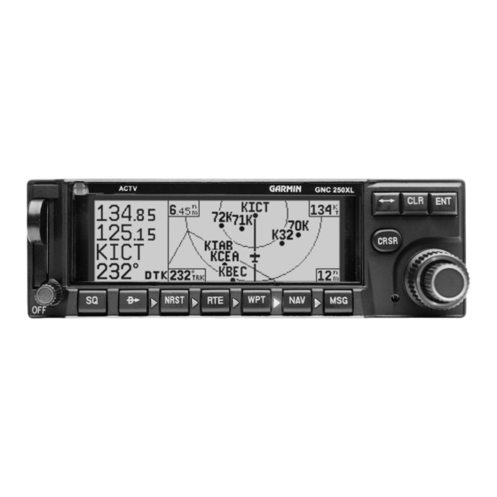
- Page 13 While the GNC 250XL is acquiring a position, let’ s take a minute to dial in the active and standby frequencies you’ll be using for the first phase of your flight. The GNC 250XL’ s display can be broken down into two separate ‘windows’, the comm window (the top line of the display) and the GPS window (the bottom three lines of the display).
- Page 14 • Present Position— Latitude and longitude displayed in degrees/minutes • Reference Waypoint— The bearing and distance to the nearest airport The position page is one of seven pages available under the GNC 250XL’ s N key: • CDI page • NAVCOM page •...
- Page 15 The GNC 250XL uses direct point-to-point navigation to guide you from takeoff to touchdown in the VFR environment. Once a destination is selected, the unit will provide speed, course and distance data based upon a direct course from your present position to your destination.
- Page 16 CDI page with ‘trk’ and ‘eta’ displayed. CDI page with ‘brg’ and ‘trk’ displayed. In addition to the destination field and graphical CDI, the GNC 250XL CDI page features four selectable fields for various navigation data so that the page may be con- figured to your own preferences (see Section 1 for more information).
- Page 17 Communication frequencies are shown in the top left corner of the map page, instead of across the top line as shown on other GNC 250XL screens.
- Page 18 2. Rotate the knob counterclockwise to decrease the map scale and show a smaller area. Another page available under the GNC 250XL’ s N key is the navigation communications (NAVCOM) page. It provides you with a complete list of airport frequencies at your departure and arrival airports, allowing convenient selection of frequencies you’ll need along your flight path.
- Page 19 2. Press 3. Press The GNC 250XL’ s T key provides the nine nearest airports, VORs, NDBs, inter- sections, user waypoints and any SUA (special use airspace) alerts, as well as the two closest FSS (Flight Service Station) and center (ARTCC) frequencies for your present position.
- Page 20 2. Press to confirm. Congratulations! You’ve now gone through the basic operation of the GNC 250XL. We encourage you to experiment with your new GPSCOM to get to know all the advanced navigation features it has to offer. If you’d like a little more practice, try using the built-in simulator described in Appendix C.
- Page 21 Whenever the N key pages are in use, the indicator light (U) next to the N key will illuminate. If the GNC 250XL requires you to enter data on a navigation page, a message prompt with specific instructions will appear and the indicator will flash.
- Page 22 CDI field will display a ‘no actv wpt’ message, and only speed and track data will be available. The CDI field is also used to display the GNC 250XL’ s turn anticipation and waypoint alert data during route operations (see section 5).
- Page 23 The following functions may be displayed in the ground speed field: • gs— Your present speed over the ground. • str— Steer direction and distance, or digital crosstrack error. An ‘L’ or ‘R’ indicates which direction to steer, while the distance value indi- cates how far you are off course.
- Page 24 Comm Frequencies The next page available from the GNC 250XL’ s N key is the map page. The map page displays your present position, using an airplane symbol (in track up mode) or a position diamond (in other orientation modes), along with nearby air- ports, VORs, NDBs, intersections, user waypoints and airspace boundaries.
- Page 25 The map display occupies the right side of the display and shows your position relative to nearby airports, navaids, user waypoints and airspaces. Different symbols are used to distinguish between waypoint types. The identifiers for any on-screen waypoints can also be displayed. Special-use and controlled airspace boundaries appear on the map, showing the individual sectors in the case of Class B or Class C airspace.
- Page 26 Map scale - lower right corner (cannot be removed) The next page available from the GNC 250XL’ s N key is the navigation com- munications (NAVCOM) page. The NAVCOM page provides a list of the airport frequencies at your departure and arrival airports, allowing convenient selection of frequencies you’ll need along your flight path.
- Page 27 If a frequency has sector or altitude restrictions, the frequency will be followed by a ‘brg?’ indication. To view restrictions on a frequency: 1. Press twice to activate the cursor in the GPS window. 2. Rotate to highlight the ‘brg?’ next to the frequency you wish to view. 3.
- Page 28 Consult current charts and NOTAMS for more complete information. The GNC 250XL position page displays your present latitude and longitude, altitude and a reference waypoint field. The altitude and reference waypoint fields are selectable to configure the page to your own preferences and current navigation needs.
- Page 29 Note: The waypoint category is listed as ‘wpt’ rather than ‘VOR’ because the GNC 250XL is not using the nearest VOR for the reference waypoint. NAV KEY SECTION...
- Page 30 Dilution of Precision (DOP) measures relative accuracy from 1 to 10. The GNC 250XL’ s satellite status page provides satellite information to monitor GPS coverage and receiver performance. This is helpful when you may be experienc- ing low signal levels due to poor coverage or installation problems.
- Page 31 The receiver status field, located at the top left of the page, can display the fol- lowing messages under various conditions: Search Sky - The GNC 250XL is searching the sky for visible satellites. You will be informed with the message ‘Searching the Sky’.
- Page 32 SECTION NAV KEY Satellite Data Page Viewing individual satellite information. The second and third lines of the satellite status page provide the satellite number and signal strength of each satellite in view. The satellite status page shows signal strength for up to eight satellites at a time. If additional satellites are being received an arrow on the ‘sat’...
- Page 33 In addition to the other five pages, the GNC 250XL features two menu pages to perform a host of planning and navigation functions. NAV Menu 1 provides access to the following functions: • Trip Planning • Density altitude/true airspeed calc.
- Page 34 NAV KEY SECTION Density Altitude & True Airspeed Density altitude/true airspeed page Fuel planning page showing calculation from pre- sent position to ‘KDAL’. The density altitude/true airspeed function is also accessed from NAV Menu 1. Density altitude is the theoretical altitude at which your aircraft will perform depending on several environmental conditions, including air pressure and total air temperature (the temperature including the heating effect of speed, read on a standard outside tem- perature gauge on most aircraft).
- Page 35 Press The GNC 250XL will calculate the range and endurance (i.e., how long the fuel will last) of your aircraft. These are found in the first field on the bottom row of the page.
- Page 36 Winds aloft page Vertical navigation page The GNC 250XL’ s winds aloft function is used to calculate the true direction and speed of any winds, and indicates whether you are flying with a head wind or tail wind, and the wind speed.
- Page 37 9. Press to activate the vertical navigation function. If you enter a value greater than the value computed by the GNC 250XL, the time before the maneuver is to begin will be displayed. When the countdown reaches 15 sec- onds, you will be informed with the message ‘Start altitude chng’. The VNAV function will automatically be cancelled if the active direct-to or route is changed in any way, and you will be informed with a ‘VNAV cancelled’...
- Page 38 1. To delete a checklist item, highlight the desired item and press 2. To delete an entire checklist, highlight the desired list and press The GNC 250XL’ s NAV Menu 2 provides access to various timer and planning func- tions, including: •...
- Page 39 The GNC 250XL’ s trip timer will automatically keep track of the duration of your current trip and can be configured to run either when the GNC 250XL is on, or when your ground speed exceeds a specified value (see section 6).
- Page 40 7. Press to compute information. When the computations are complete, the GNC 250XL will display whether or not RAIM is available for the specified waypoint at the specified date and time. Refer to the table on page 78 for specific RAIM protection limits as they relate to CDI scale figures.
- Page 41 ‘Change oil’ to be displayed in 30 hours, the message ‘Change oil’ will be displayed after the GNC 250XL has been running in Normal mode for 30 hours. After appearing, the message will be displayed each time the GNC250XL is turned on until it is changed or deleted.
- Page 42 Sunrise/sunset planning page showing UTC (Zulu) sunrise and sunset times for ‘KROG’. The GNC 250XL’ s sunrise/sunset planning function allows you to calculate the time of sunrise or sunset at any waypoint or your present position for a specified date.
- Page 43 The GNC 250XL features a digital VHF radio that provides a seamless transition from communication to navigation, bringing the two most important functions in fly- ing together in one panel-mount unit. The GNC 250XL operates in the aviation voice band, from 118.000 to 136.975 MHz, in 25 kHz steps.
- Page 44 To select a frequency from a list, highlight the desired frequency and press E. During the course of navigating with the GNC 250XL, there may be times when you need to quickly select a comm frequency while you are entering data in the GPS window.
- Page 45 1. Rotate the knob. Whenever the GNC 250XL is powered up, the automatic squelch will be in the ‘on’ position, allowing only transmissions which are powerful enough for clear broad- cast to be received. Manual squelch control is not available.
- Page 46 @ for more than two seconds. The GNC 250XL’ s emergency channel select feature provides a quick method of selecting the 121.5 MHz frequency as the active frequency in the event of an in-flight emergency. The emergency channel select is available whenever the unit is on, regardless of GPS or cursor status, or loss of the display.
- Page 47 Waypoint information is available through four primary waypoint pages accessible from the GNC 250XL’ s W key. The waypoint pages may be scrolled through by press- ing the W key and rotating the outer knob until the desired page is displayed, or by pressing the W key repeatedly.
- Page 48 The airport position page shows the position, field elevation and available fuels for the selected airport. The GNC 250XL organizes waypoints into one of five waypoint categories for your convenience. Each waypoint category provides different types of detailed infor- mation for a selected facility: •...
- Page 49 5. Use to enter the location or the name, and press As the information is entered, the GNC 250XL will display any entries in its data- base that match the letters you have entered. If duplicate entries exist for the entered identifier, name or location, additional entries may be viewed by rotating K.
- Page 50 Once a waypoint category and identifier have been selected, the GNC 250XL will provide extensive information through a set of waypoint pages for the selected cate- gory. The pages available for each waypoint category are presented here in the order they appear on the waypoint menu page: airports, VORs, NDBs, intersections and user waypoints.
- Page 51 The GNC 250XL features five airport pages: airport identification— allows entry of desired airport by identifier, facility name or city; displays region and/or country of facility. airport position— allows entry of desired airport by identifier; displays latitude, longitude and elevation; indicates usage and fuel availability;...
- Page 52 Elevation— In feet or meters Usage/Fuel— If the airport is for military use, it will display ‘military’. If it is private, the GNC 250XL will display ‘private’. If it is a public airport, it will display the fuel type(s) available: •...
- Page 53 The airport communication page displays the radio frequencies and usage for the selected airport, as well as sector and altitude restrictions. To view the communication page from any of the airport information pages: 1. Rotate with the cursor removed to display the communication page. 2.
- Page 54 WPT KEY SECTION Airport Runway Page Airport runway page for KICT. To view additional runways, rotate the the direction of the arrow prompts. The airport runway page displays runway designations, length, surface and lighting for the selected airport, as well as ILS/localizer and/or pilot-controlled light- ing frequencies.
- Page 55 VOR Information The GNC 250XL features three VOR waypoint pages: VOR identification— allows entry of desired VOR by identifier, facility name or city; displays region and/or country of facility. VOR position— allows entry of desired VOR by identifier; displays latitude, longitude and frequency; provides magnetic variation, weather broadcasts and DME/TACAN information.
- Page 56 NDB Information NDB Position Page The GNC 250XL also uses identification, position and comments pages for NDB information. The NDB waypoint pages are used in the same manner as VOR pages: NDB information is accessed by entering the desired facility’ s identifier, city or name (see page 39) on the NDB identification page.
- Page 57 Intersection Information Intersection Position Page The last database waypoint category available is intersections. Two intersection pages are available: intersection position and intersection comments. Intersections may be entered by identifier only (not city or name) on either intersection page. To scroll through the intersection pages: 1.
- Page 58 In addition to the airport, VOR, NDB and intersection waypoints contained in your NavData® card, the GNC 250XL allows you to store up to 1,000 user-defined way- points. Once a user waypoint is created, two user waypoint pages will display the fol- lowing information: •...
- Page 59 If the waypoint identifier entered does not exist, you will be prompted to select a method to enter the new waypoint’ s position into memory. If the waypoint exists (i.e., you’re just reviewing or editing a user waypoint), skip step 4 and move on to the next set of instructions.
- Page 60 To create a user waypoint from your present posi- tion, leave the reference waypoint field blank and enter a bearing and distance from your present position. The GNC 250XL will calculate the new waypoint’s coordinates automatically. To enter/edit a user waypoint position from a reference waypoint: 1.
- Page 61 This will display the ‘Save waypoint’ screen, which will allow you to rename the waypoint and choose the route to which it should be added. The GNC 250XL will assign the next available three-digit number as the default waypoint name, preceded by a ‘+’...
- Page 62 ‘Proximity overlap’. This message will be displayed each time you turn on the GNC 250XL for as long as the overlap remains. Warning: If you enter the overlap area you will only be informed of the nearest proximity waypoint.
- Page 63 The third page available from the GNC 250XL’ s W key is the user waypoint list, which can be used to quickly scan, review, rename or delete user waypoints. To display the user waypoint list: 1. Press and use to display the user waypoint list.
- Page 64 Entering waypoint comments. Waypoints with comments page The last page available through the GNC 250XL’ s W key is the waypoints with comments page, which lists all waypoints that have a user comment. User com- ments may be added to 250 waypoints stored in the user or NavData allow you to note two lines of special information concerning a particular waypoint.
- Page 65 If there is more than one waypoint available for a selected identifier, the GNC 250XL will display a duplicate waypoint page for you to choose the desired waypoint. The waypoint identifier and number of duplicates will be shown at the top of the page, with the waypoint type and region of each duplicate indicated below.
- Page 66 (identifier, facility or city name). 5. Use to enter the letters of the identifier, city or facility name. The GNC 250XL will scan the database and display the first waypoint that matches your entry. 6. Press to accept the waypoint, and function being used.
- Page 67 (ARTCC/FIR) points of communication, plus alert you to any Special Use Airspace (SUA) you may be in or near. The T key can be used in conjunction with the GNC 250XL’ s direct-to function to quickly set a course to a nearby facility in case of an in-flight emer- gency.
- Page 68 O. Rotating O continuously to the left will stop page selection on the nearest airport category. The next page available under the GNC 250XL’ s T key is the SUA (special-use airspace) alert page. The SUA alert page will alert you to as many as nine controlled or restricted airspaces near or in your flight path, according to the following conditions: •...
- Page 69 To toggle between the SUA name and controlling agency display: 1. Rotate one stop in either direction. If the SUA name or controlling agency is too long to fit on the display, the GNC 250XL will automatically scroll to display the rest of the information. Alert type...
- Page 70 Frequency information for SUA. If the informa- tion is too long to fit on the display, the GNC 250XL will automatically scroll to display the rest of the information. The following SUA types can appear in the SUA type field:...
- Page 71 All SUA alert messages except for prohibited areas may be turned on or off through the GNC 250XL’ s unit settings options, found under the M key (see page 84). Alerts for prohibited areas will always be displayed, regardless of unit settings or operating mode.
- Page 72 ACTIVE LEG KTUL As you pass each waypoint in the route, the GNC 250XL’ s automatic leg sequenc- ing and turn anticipation features will automatically select the next waypoint as the ‘active to’ waypoint and provide smooth steering guidance around the turn. If you are not currently navigating a particular route leg (e.g., your starting position is not a...
- Page 73 1. Place the cursor over the destination field on the CDI page. 2. Press \. The destination field will go blank. 3. Press E. The GNC 250XL will resume navigating route 0 (the active route) if available. to accept the direct-to confirmation page.
- Page 74 4. Press to accept the course, and The GNC 250XL will now use the selected course for your CDI and DTK steering guidance. To reset the course to a GPS-calculated course from your present position, simply press D, followed by E.
- Page 75 The route catalog page serves as the main page for creating, edit- ing, activating, deleting and copying all routes. Routes 1-19 are used as storage routes, which are stored in the GNC 250XL’ s inter- nal memory. Once a storage route is ‘activated’, it is placed into route 0 for navigation until it is cancelled, overwritten by activating another route or erased when the GPS is turned off.
- Page 76 ROUTES SECTION Creating & Editing Routes Selecting the route edit function. Adding a waypoint to route 2. The route action field, located at the top right of the page, is used to select the desired route operation. The following functions are available: •...
- Page 77 ‘activate?’. Press After travelling a route or creating a route with the GNC 250XL’ s AutoStore feature, the route activation field may be used to activate the route in reverse order. To activate a route in reverse order: 1.
- Page 78 ROUTES SECTION Copying Routes CPA Function Calculating closest point of approach. Closest point of approach to ‘TXK’. The route action field also features a copy function that permits you to copy any route to another open storage route. The copy function can be used to save the con- tents of the active route (route 0) to an open storage route.
- Page 79 The GNC 250XL’ s search and rescue function provides navigation guidance for search and rescue operations, navigating in a ladder pattern to maximize coverage and efficiency. This is done in reference to two waypoints called ‘anchor waypoints’. The first leg will be a specified distance from the line connecting the anchor waypoints.
- Page 80 During route navigation, it is sometimes desirable to navigate a specified distance away from the ‘active leg’ to help avoid certain airspaces or regions. The GNC 250XL’ s parallel track feature will automatically guide you along a selected offset from the active leg.
- Page 81 By under- standing the relationship between the active route and CDI pages and the role of the waypoint sequencing selector, you’ll be able to get the most out of the GNC 250XL’ s advanced route features.
- Page 82 ROUTES SECTION Active Route Page Inserting Waypoints Active route page with cumulative distance (cum) and desired track (dtk) displayed. Active route page with leg distance and estimated time enroute displayed. The leg field can be selected to display cumulative distance or the distance for each route leg.
- Page 83 ‘ok?’ prompt on the waypoint confirmation page. The GNC 250XL will now provide guidance to the selected waypoint and resume navigating the remainder of the route in sequence once you arrive at the next destina- tion waypoint. The waypoint sequencing field, located at the bottom left of the direct-to confirmation page, allows you to select manual or automatic waypoint sequencing of route waypoints.
- Page 84 The GNC 250XL will automatically sequence to the next leg when you are abeam the ‘active to’ waypoint on the curved transition segment, and the to/from indicator on the CDI will flip momentarily.
- Page 85 Section 6 Messages and Unit Settings The GNC 250XL’ s M key provides access to system messages and allows you to customize the unit to your own preferences through a settings submenu. Whenever the GNC 250XL needs to alert you to a navigation, communication or system message, the annunciator light (U) next to the M key will flash.
- Page 86 The GNC 250XL’ s map page is designed to be a flexible tool that can be custom- tailored to your navigation needs. The map setup page provides access to many of the features and functions that will help you configure the map page to your own preferences.
- Page 87 The map setup page also allows you to control whether or not the various way- point types and the identifiers for these waypoints are displayed. Settings for each waypoint type allow you to select the maximum scale at which that feature should be displayed, or you may turn that waypoint type off for all scales.
- Page 88 30 nm of a departure airport. Note that the GNC 250XL uses Receiver Autonomous Integrity Monitoring (RAIM) to cross-check its position.
- Page 89 ‘user’ setting will correct information to an entered value. The GNC 250XL’ s arrival alarm can be set to notify the pilot with a message when you have reached a user defined distance to a final destination waypoint (the direct-to waypoint or the last waypoint in a route).
- Page 90 During this time, the GNC 250XL will continue to navigate and track satellites, but will not backlight the display until a key is pressed or a knob is turned.
- Page 91 To change the display contrast settings: 1. Press and hold and rotate to show the ‘Display’ page. 2. Press twice and use to select ‘auto’ or ‘manual’ control. 3. Press 4. If ‘manual’ is selected, use to set the display constrast level. (If ‘auto’ is selected you may also change the offset level to your preference.) 5.
- Page 92 UNIT SETTINGS SECTION Backlighting Trip Timer The backlight intensity settings page is used to set/adjust the screen backlighting for day or night time operation. Trip timer settings, showing timer active when groundspeed exceeds 100 knots. To change the backlighting intensity: 1.
- Page 93 The GNC 250XL can be configured to display data in standard or metric units of measure. These apply to: distance, position, speed, altitude, fuel, pressure and temperature. To change the units of measure: 1. Press and hold and rotate to display the nav units page.
- Page 94 UNIT SETTINGS SECTION SUA Settings Altitude Buffer The SUA settings page with all airspace alerts enabled and the altitude buffer set to 100 meters. The SUA settings page with ‘other’ airspaces dis- abled and the altitude buffer set to 500 feet. The Special Use Airspace settings page will allow you to turn the controlled/ restricted airspace message alerts on or off.
- Page 95 By default, your unit calculates positions using the WGS 84 map datum. If you are using charts based on another datum, you must set the GNC 250XL to use the same datum. Using a map datum that does not match the charts you are using can result in significant differences in position information.
- Page 96 I/O Settings I/O page settings The last page available under the GNC 250XL’ s setup menu is the I/O setup page. The I/O setup page lets you configure the GNC 250XL to input RTCM SC-104 correction data, output to a RS-232 mapping device or a PC (with the optional GARMIN PC Kit or other mapping software) and select the appropriate baud rate.
- Page 97 The NavData card supplied with your GNC 250XL can be installed or removed when the GNC 250XL is on or off. Insert the card with the thumb tab at the top, and the beveled corner at the bottom. If the NavData card is not present when the unit is powered on, you will receive a ‘No Jeppesen database’...
- Page 98 7. To continue with more data transfer types, repeat steps 4, 5 and 6. Otherwise, press E when ‘ok?’ is highlighted. 8. Turn the GNC 250XL off and replace the user data card with a NavData card. The GNC 250XL is now ready for normal operation.
- Page 99 2. Rotate the wrench counterclockwise until it stops to ensure the pawl latch is in the proper position. 3. Insert the GNC 250XL into the aviation rack and rotate the wrench clockwise to secure the unit. To ensure proper connector seating, gently press on the left side of the unit until tightened.
- Page 100 Operating mode page Selecting the simulator mode. The GNC 250XL’ s simulator mode allows you to plan and practice flights in your home and office using an optional remote battery pack or AC adapter. The simula- tor is not accessible when the GNC 250XL is running off the master avionics switch.
- Page 101 4. Use to enter the desired speed. Press To exit the simulator mode, the GNC 250XL must be turned off by rotating the B knob counter-clockwise until the unit shuts down. All waypoints and routes creat- ed in simulator mode will be retained in the GNC 250XL’ s internal memory.
- Page 102 Appendix D GNC 250XL Messages and Abbreviations The GNC 250XL uses the Message Page to communicate important information to you. Some messages are advisory in nature, others are warnings that may require your intervention. This appen- dix provides a complete list of GNC 250XL messages and their meanings.
- Page 103 Configuration reset - The GNC 250XL has detected a failure in its installation configuration memory. Data from the user memory has been used to reset the configuration. Check the installation settings for correctness. If the message persists, the unit is not usable and should be taken to an authorized service center for repair.
- Page 104 - The parallel track distance is too large for the active route. Osc needs adjustment - The GNC 250XL has detected excessive drift in its internal crystal oscillator which may result in longer acquisition time. The unit should be taken to an authorized service center immediately.
- Page 105 CDI scale may remove the conditions causing this message. RAM failed - The GNC 250XL has detected a failure in its internal memory. If the message persists, the GNC 250XL is unusable and should be taken to an authorized GARMIN service center.
- Page 106 APPENDIX MESSAGES & ABBREVIATIONS Searching the sky - The GNC 250XL is in the search-the-sky mode. Allow the unit to complete data col- lection before turning it off. Start altitude chng - The altitude change entered on the VNAV Planning page is about to begin.
- Page 107 This section of Appendix D provides a complete list of GNC 250XL abbreviations and their meanings. ALT- Altitude DEG- APP- Approach DEP- APR- Approach DIS- APT- Airport Waypoint DME - ARTCC- Air Route Traffic Control Center DOP- ARV- Arrival DTK-...
- Page 108 APPENDIX MESSAGES & ABBREVIATIONS ILS- Instrument Landing System MSA- Imperial Gallons INT- Intersection Waypoint MUL- JET A- Jet Fuel - Type A NDB- JET B- Jet Fuel - Type B Kilometers Per Hour Kilometers Knots OBS- Pounds LCL- Local OTH- LEN- Length ºC-...
- Page 109 RNWY- Runway USR- UTC- RSTCD- Restricted RSV- Reserves RTE- Route VNAV- Receive Only SAR- Search And Rescue VOR- WPT- SEC- Seconds SEQ- Sequence SGL- Signal XFR- SLCT- Select SRFC- Surface STR- Steer To TACAN- TACtical Air Navigational Aid TAS- True Airspeed TAT - Total Air Temperature TEMP-...
- Page 110 ** Subject to accuracy degradation to 100m 2DRMS under the US DOD-imposed Selective Availability Program. Whenever the GNC 250XL is connected to the optional remote battery pack and power from the master switch is lost, the unit will revert to battery power.
- Page 111 Appendix F Map Datums ADINDAN Ethiopia, Mali, Senegal, DOS 1968 Sudan AFGOOYE Somalia EASTER ISLAND 1967 AIN EL ABD 1970 Bahrain Island, Saudi Arabia EUROPEAN 1950 ANNA 1 ASTRO 1965 Cocos Islands ARC 1950 Botswana, Lesotho, Malawi, Swaziland, Zaire, Zambia, Zimbabwe ARC 1960 Kenya, Tanzania EUROPEAN 1979...
- Page 112 APPENDIX MAP DATUMS LUZON PHILIPPINES Philippines (excluding Mindanao Isl.) MAHE 1971 Mahe Island MARCO ASTRO Salvage Islands MASSAWA Eritrea (Ethiopia) MERCHICH Morocco MIDWAY ASTRO 1961 Midway Island MINNA Nigeria NAD27 ALASKA North American 1927- Alaska NAD27 BAHAMAS Bahamas (excluding San Salvador Island) NAD27 CANADA Canada (including...
- Page 113 Appendix G Index Abbreviations 97-99 Cautions Accessory list CDI page Activating a route CDI sensitivity setting Activating a route in reverse Channel 2 I/O Active frequency 3, 33 Checking GPS coverage Active to & from waypoints Checklists Active route page Clear key Adding waypoints to a route 66, 72...
- Page 114 APPENDIX INDEX Direct-to cancelling 9,63 Direct-to key vii,5,63 Inner knob Direct-to navigation 62-64 Installation of the GNC 250XL Display contrast Intersections Display mode I/O Outputs Displaying airports Displaying identifiers Displaying airspace boundaries Key functions Knob functions Downloading data to another GNC 250...
- Page 115 RAIM prediction Sunrise/sunset planning RAIM protection Squelch Radar information Receiver status Reference waypoint Table of contents Removal of the GNC 250XL Time Renaming user waypoints Transfer key Restoring user data Trip planning Reversing a route Trip timer Route catalog page...
- Page 116 APPENDIX INDEX Unit settings 75-86 Units of measure User data cards User waypoints 38,48-51,53 Vertical navigation (VNAV) 26-27 Volume vii,35 VORs 38,45 Warranty Waypoint categories Waypoint comment list 37,54 Waypoint comments page Waypoint confirmation page Waypoint entry Waypoint holding 73-74 Waypoint identification page Waypoint information 37-56...
- Page 118 © 1997 GARMIN Corporation 1200 East 151st Street Olathe, KS 66062 GARMIN (Europe) LTD Unit 5, The Quadrangle, Abbey Park Industrial Estate, Romsey, SO51 9AQ, UK Web Site Address: www.garmin.com Part No. 190-00067-60 Rev. A...