Table of Contents
Advertisement
Advertisement
Table of Contents

Related Manuals for Garmin GPSMAP 65


Summary of Contents for Garmin GPSMAP 65
- Page 1 GPSMAP 65/65S ® Owner’s Manual...
- Page 2 © 2020 Garmin Ltd. or its subsidiaries All rights reserved. Under the copyright laws, this manual may not be copied, in whole or in part, without the written consent of Garmin. Garmin reserves the right to change or improve its products and to make changes in the content of this manual without obligation to notify any person or organization of such changes or improvements.
- Page 3 Device Information............11 Editing a Route ..............4 Product Updates ............... 11 Viewing a Route on the Map ..........4 Setting Up Garmin Express ..........11 Deleting a Route ..............4 Registering Your Device ............11 Navigating a Saved Route ............. 4 Viewing E-label Regulatory and Compliance Information ..
- Page 4 Troubleshooting ................ 13 Restarting the Device ............13 Viewing Device Information ..........13 Restoring All Default Settings ..........13 Index ................14 Table of Contents...
-
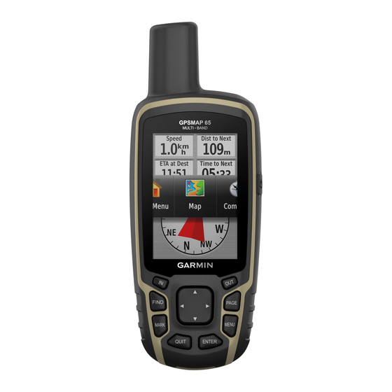
Page 5: Device Overview
Do not attempt to use the device to charge a battery that was page not provided by Garmin . Attempting to charge a battery that ® was not provided by Garmin can damage the device and void • Decrease the map drawing speed (Advanced Map Settings, the warranty. page •... -
Page 6: Using The Main Pages
A question mark flashes while the device determines your location. Select to open the status page. shows the satellite signal strength. When the bars are full, the device has acquired satellite signals. Using the Main Pages The information needed to operate this device is found on the main menu, map, compass, trip computer, and elevation plot pages. -
Page 7: Trip Computer
Guidance Text: Customizes when guidance text is shown on Heading Settings the map. You can customize the compass settings. Text Size: Selects the text size for map items. Select Setup > Heading. Detail: Selects the amount of detail shown on the map. Showing Display: Sets the type of directional heading shown on the more detail may cause the map to redraw more slowly. -
Page 8: Restoring Default Page Settings
Restore Defaults: Restores the elevation plot to factory default Routes settings. A route is a sequence of waypoints or locations that leads you to your final destination. Calibrating the Barometric Altimeter You can manually calibrate the barometric altimeter if you know Creating a Route the correct elevation or the correct barometric pressure. -
Page 9: Purchasing Additional Maps
Navigating a Saved Track chirp ™ Select FIND > Tracks. A chirp is a small Garmin accessory that is programmed and left Select a saved track. in a geocache. You can use your device to find a chirp in a Select Go. -
Page 10: Area Calculation
See your operating system Setting a Proximity Alarm documentation to learn how to map the drive. Open the Garmin or memory card drive or volume. Proximity alarms alert you when you are within a specified range of a particular location. -
Page 11: Customizing The Device
Download and open the Garmin Explore app. ™ the moon phase, based on your GPS position. Log in to the Garmin Explore app using your Garmin Connect username and password. Customizing the Device Select the device option to pair your device with the Garmin Explore app. -
Page 12: System Settings
Descent - Maximum: The maximum rate of descent in feet per Speed - Overall Avg.: The average speed while moving and minute or meters per minute since the last reset. stopped since the last reset. Descent - Total: The total elevation distance descended since Stopwatch Timer: The stopwatch time for the current activity. -
Page 13: Display Settings
Appearance: Sets the appearance of marine navigation aids on Select Setup > System > Interface. the map. Garmin Spanner: Allows you to use the device USB port with Marine Alarm Setup: Sets alarms for when you exceed a most NMEA 0183-compliant mapping programs by creating a specified drift distance while anchored, when you are off virtual serial port. -
Page 14: Altimeter Settings
Altimeter Settings NOTE: The altimeter is available only with GPSMAP 65s devices. Select Setup > Altimeter. Auto Calibration: Automatically calibrates the altimeter each time the device is turned on. Barometer Mode: Variable Elevation allows the barometer to measure changes in elevation while you are moving. Fixed Elevation assumes the device is stationary at a fixed elevation, so the barometric pressure should only change due to weather. -
Page 15: Device Information
• GGZ geocache files. Go to www.garmin.com/geocache. Attaching the Wrist Strap • JPEG photo files. Insert the loop of the wrist strap through the slot in the • GPI custom POI files from the Garmin POI Loader. Go to device. www.garmin.com/products/poiloader. Installing a Memory Card WARNING Do not use a sharp object to remove user-replaceable batteries. -
Page 16: Specifications
Open the Garmin drive or volume. The device withstands incidental exposure to water of up to 1 m for up to 30 min. If necessary, open a folder or volume. -
Page 17: Troubleshooting
• Before you pair the ANT+ accessory with your Garmin device, move 10 m (33 ft.) away from other ANT+ accessories. • Bring the Garmin device within range 3 m (10 ft.) of the ANT+ accessory. • After you pair the first time, your Garmin device automatically recognizes the ANT+ accessory each time it is activated. - Page 18 4 acquiring 2 screen, settings 9 settings 2, 3, 5, 8–10, 13 files, transferring 5, 11, 12 device 10 sharing data 5 Sight N' Go 3 Garmin Connect 7 smartphone 7 Garmin Express 11 applications 7 updating software 11 pairing 7 geocaches 5, 11 software downloading 5 license 13 GLONASS 9 updating 11 GPS 6, 9 version 13...
- Page 20 September 2020 GUID-EA40F185-39D1-4C3B-B512-7AA823FA3DB5 v1...