Table of Contents
Advertisement
EFIS
Ultra
Product model number: UX0EFS3xAM / UX0EFS5xAM
Software: version 5.21.2R or more recent
Firmware: version 3.15 or more recent
User and Installation Manual
IMPORTANT: Before using this manual check if your Ultra product model number corresponds to the above model number.
Your journey, Our technology
Advertisement
Table of Contents

Related Manuals for AvMap Ultra EFIS


Summary of Contents for AvMap Ultra EFIS
- Page 1 EFIS Ultra Product model number: UX0EFS3xAM / UX0EFS5xAM Software: version 5.21.2R or more recent Firmware: version 3.15 or more recent User and Installation Manual IMPORTANT: Before using this manual check if your Ultra product model number corresponds to the above model number. Your journey, Our technology...
-
Page 3: Table Of Contents
The pilot in command assumes total responsibility and risk associated with the use of this device and remains solely responsible for flying in safe conditions. AvMap disclaims any liability deriving from an improper use of the device, in a way that may violate the flight and navigation rules, regulations and safety. -
Page 4: Overview
HSI page , providing its position, direction and radials relative to reference navigation points. Preloaded navigation POI’s Ultra is preloaded with Jeppesen navigation POI’s: Airports, NDB’s and VOR’s. Coverage available: Europe-Africa, North America, South America, Asia-Australia. For updates contact orders@avmap.it. - User and Installation Manual... -
Page 5: Installation
AvMap Ultra EFIS Micro SD card A microSD card is included in the Ultra box. The microSD card is a blank card without data preloaded. The microSD card should be used for updating the software and navigation POI’s. Note: For more details see Chapter 4. - Page 6 AvMap Ultra EFIS The instrument has to be installed from the front of the panel and screwed from behind the panel according to Figure 3. 77,5 mm (3.05”) Figure 2 The screw length that need to be used for panel installation depend on the panel thickness and is based on the following formula: 5mm ≤...
- Page 7 AvMap Ultra EFIS Aircraft instrument panel Panel thickness Figure 3 IMPORTANT: Make sure you respect the screw length formula to avoid damaging the plastic of the Ultra. Use light thread locker to prevent screw loosening with vibration. Use the Cutting template, included in the box, to cut out the panel. (see Figure 4)
-
Page 8: Connections & Wiring
& serial connector, and the GPS receiver connector (see Figure 5). RECEIVER Power Supply Wire color Function External Positive Power +10 35Vdc 1A Fuse Black External Power GND Ultra EFIS (rear view) Grey RS232 Serial Data TX GENERIC RS232 Brown RS232 Serial Data RX EXTERNAL DEVICE... - Page 9 GPS port as shown on Figure 5. The GPS receiver comes with a 1,5 meter cable and is designed for use inside the aircraft. Note: an additional gps extension cable of 2 meter is available at the AvMap dealer and AvMap webshop.
-
Page 10: System Calibration
AvMap Ultra EFIS wire remains out of function and is to necessary to be connected to the external device. Note: See paragraph 4.5 for NMEA-OUT settings. 3. System Calibration There are three types of calibration procedures; 1. Horizon alignment calibration 2. -
Page 11: Compass Calibration (Magnetometer)
& level flight attitude. AvMap recommends to perform the calibration on the ground. Note: For a successfull calibration in flight, the process should be performed by a second person (not by the pilot) and flight conditions must be safe and stable without wind influence. - Page 12 AvMap Ultra EFIS magnetic north, are painted every 30° which is used to perform a compass calibration. Compass calibration procedure: STEP 1: Prepare aircraft position and system Taxi the aircraft to the airports compass rose or an open field free from magnetic disturbances.
-
Page 13: Altimeter Calibration
(GPS or compass) to fly into the requested direction. Calibration in flight should be performed by a second person (not the pilot) in safe and stable flight conditions. AvMap disclaims any liability. 3.3 Altimeter calibration Ultra EFIS contains a barometric altimeter. -
Page 14: Field Calibration
3.3.2 Factory calibration The factory calibration is the calibration activity performed in AvMap Laboratory. AvMap recommends to send the Ultra EFIS in factory every 2 years for complete device checkup, including altimeter calibration. Contact avionics@avmap.it to receive information about the complete checkup service costs. -
Page 15: Pfd Mode
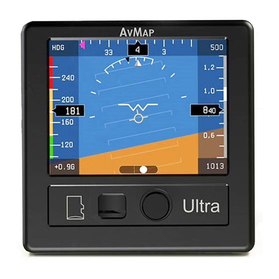
AvMap Ultra EFIS SETUP DATABASE CALIBRATE NMEA-OUT Setup Menu PFD Menu Figure 9 While in PFD mode, pushing once the rotation knob an option menu window appears on the display. Rotate the knob to select a menu and confirm by pushing the rotation knob. - Page 16 AvMap Ultra EFIS Attitude is displayed with a standard coloured artificial horizon. An aircraft symbol is used to indicate the aircraft’s nose orientation. A trajectory vector (also called “Flight Path Vector”) is displayed with a circle and three lines; the trajectory vector indicates the aircrafts real path with respect to the horizon and the aircraft’s nose.
- Page 17 AvMap Ultra EFIS Vertical Speed Indicator (VSI) is shown in the upper right corner of the PFD page in a numeric number (ft/min or m/s) and on the VSI scale bar aside the altimeter bar (segmentation in 1000 ft/min or 5 m/s). The unit measurement set for altitude is automatically used on the vertical speed indicator (when altitude is set to feet the VSI is shown in ft/min, when altitude is set to meters the VSI is shown in m/s).
-
Page 18: Hsi Display Mode
AvMap Ultra EFIS 4.3 HSI display mode The HSI shows navigation data: position, distance, directions, and radials relative to reference navigation points. Figure 11 shows the data layout on the screen: Wind Heading Bug Heading (Estimated) Indicator indicator Altimeter Current Position... - Page 19 AvMap Ultra EFIS speed even in the absence of GPS, with degraded quality; this is indicated by a change in colour (RED) in the ground speed indicator. Note: In the “SETUP” menu select your preference unit for speeds: knots, kph, mph or m/s.
-
Page 20: Setup Mode
In the “DATABASE” menu you can choose “IMPORT” to update navigation POI’s on the Ultra through the microSD card. Make sure the microSD card is inserted in the Ultra. Note: To update the navigation POI’s on your Ultra visit www.avmap.it or contact orders@avmap.it. Follow the update instructions that are provided together with the POI purchase. -
Page 21: Nmea-Out
• DISTANCE: Distance to an VOR or ADF navigation point can be set in nm, miles or km. 4.5 NMEA-OUT The Ultra EFIS comes with two RS232 serial connections (“Serial A” and “Serial B”), both can be enabled for sending out gps data (NMEA messages) to external devices (autopilot, transponder, navigation or EFIS system). -
Page 22: Software Update
AvMap Ultra EFIS 5. Software update Download the software update file from www.avmap.it/support and copy the software file on the mSD card. Insert the microSD card into the Ultra while the Ultra is turned OFF. Turn the Ultra ON providing power supply to the device. -
Page 23: Technical Specifications
The first two causes can be solved by updating the software with the latest available software version. If a software update doesn’t resolve the failure the Ultra requires service at AvMap facility. 7. Technical Specifications Software: •... - Page 24 AvMap Ultra EFIS Hardware: • Dimensions: 95 x 95 x 78 mm (3.74” x 3.74” x 3.07”) • Diameter: 77,5 mm (3.05”); Installing diameter: 79,5 mm (3 1/8”) • Weight: 230 g (8.1 oz) • Display: 3.5”; 320 x 240 pixels, brightness 500 cd/m2 •...
-
Page 25: Appendix A - Nmea Messages
Appendix A - NMEA messages APA Autopilot Sentence “A” contains navigation receiver warning flag status, crosstrackerror, Waypoint arrival status and initial bearing from origin Waypoint to the destination Waypoint for the active navigation leg of the journey. APB Autopilot message contains all of the above plus: heading to steer toward destination, bearing from the present position to the destination (magnetic or true). - Page 26 EFIS Ultra www.avmap.it www.avmap.us MAEFSAM1AE040 www.avmap.com.br ÑMAEFSAM1AE040ËÓ...