Sign In
Upload
Manuals
Brands
Cobra Manuals
GPS
Marine MC 600Cx
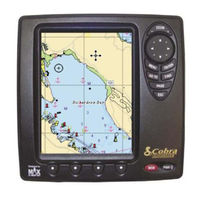
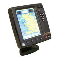
Cobra Marine MC 600Cx Manuals
Manuals and User Guides for Cobra Marine MC 600Cx. We have
2
Cobra Marine MC 600Cx manuals available for free PDF download: Owner's Manual, Quick Reference Manual
Cobra Marine MC 600Cx Owner's Manual (102 pages)
Marine Chart Plotter
Brand:
Cobra
| Category:
GPS
| Size: 3.26 MB
Table of Contents
Customer Assistance
3
Our Thank to You
3
Control and Indicators
4
Software Buttons Functionality
4
Software Features
5
Technical Specifications
5
Warnings and Cautions
6
Screen Cleaning Precautions
6
What Is in the Box
7
MC 600C Chart Details
7
Table of Contents
8
1 Manual Organization
8
General Operation
12
Button Conventions Used
12
Menu Description
12
Selecting an Option
12
Alphanumeric Input Procedure
13
2 Basic Operation
15
Switching On/Off
15
Switching on
15
Switching off
15
Auto Power on Description
15
Initial Setup
15
Definitions of Selections
16
Adjusting the Backlighting and Contrast
17
Page Surfing
18
Pages Selection
18
Demo Mode
19
Full Demo
19
Demo a Route
19
Custom Demo
19
Moving and Zooming on Chart
19
Pan
19
Zoom
20
Esc Back to Chart
20
Changing Data Fields on most
20
Number of Data Fields
20
Change Data Fields
21
Available Data Options
22
Creating a User Point
22
Creating a New Waypoint
22
Creating a New Mark
23
Creating a Basic Route
23
Using Goto
24
Using Find
24
Using Mob
25
Inserting MOB
25
Deleting MOB
25
3 Page Information and Operation
26
Page Selection and Presets - Setup
26
Welcome Page
27
Operations
27
Chart Only Page
29
Description
29
Operations
29
Available Layouts of CHART Page
29
Changing Data Options
29
Operations on User Points
30
Software Buttons
30
Menu
30
Data Fields
31
Data Page
32
Description
32
Operations
32
Available Layouts of DATA Page
32
Changing Data Options
32
On Screen Instructions
33
Menu
33
Highway Page
35
Description
35
Operations
35
Available Layouts of HIGHWAY Page
36
Zoom in and Zoom out
36
Menu
36
Sun and Moon Page
37
Description - "Telling" Tide
37
Operations
37
Available Layouts of SUN and MOON Page
38
Finding the Nearest Tide Stations
38
Finding a Tide Station on a Map
38
Changing the Date for the Tide Chart
39
Various Animation Options
39
Fish Finder Page
40
Description
40
Understanding the Fish Finder Echogram
42
Operations
43
Available Layouts of FISH FINDER Page
43
Changing Data Options
43
Split Mode of the FISH FINDER Page
43
Menu
43
Combo Mode Page
46
Description
46
Operations
46
Moving the Location of the Chart Window
46
Available Layouts of COMBO MODE Page
47
Changing Data Options
47
Changing the Size of Windows
47
Screen Control
48
Split Mode Page
49
Description
49
Available Layouts of SLIT MODE Page
49
Changing Data Options
49
Changing the Size of Windows
50
Changing the Screen Control
50
Menu
50
CHART Page
50
HIGHWAY Page
50
FISH FINDER Page
50
Gps Page
51
Description
51
Changing Data Options
51
Menu
52
System Page
53
Description
53
Each Setting Description
53
4 Advanced Operation
54
Measure Function
54
Advanced Waypoint Operations
54
Deleting a Waypoint
54
Moving a Waypoint
55
Inserting a Waypoint
55
Editing a Waypoint
55
Route Operations
55
Selecting Existing and Naming New Routes
56
Basic Route List Operations
56
Using Track
57
User Points List
58
Selecting Existing and Naming New User Points
58
Basic User Point List Operations
58
User C-Card Operations
59
User C-CARD Page
59
Formatting User C-CARD
59
Saving File on User C-CARD
60
Loading File from User C-CARD
60
Deleting File from User C-CARD
60
Info
61
Setting Automatic Info
61
Selecting Automatic Info
61
Info on Objects with Pictures
61
Info Tree and Expanded Info Page
62
Current Predictions
62
Dynamic Nav Aids
62
Pictures
63
Dsc Calling
63
Advanced DSC for VHF Radio with NMEA 0183 Output
64
Contact List
64
5 System
65
Screen Shot and Descriptions
65
Operations by Setting Group
65
Display Settings
65
Chart Settings
66
Chart Presentation
66
Depth Presentation
68
Land Presentation
69
Advanced Chart Settings
69
General
72
Fish Finder Settings
72
Display Settings
73
Sensitivity Settings
73
Transducer Settings
74
Alarm Settings
75
General Alarms
75
GPS Alarms
75
Fish Alarms
76
Units
76
Pages On/Off
77
GPS Settings
77
Demo
78
Custom Demo
78
Com Settings
79
About
80
6 Installation
81
Basic
81
Chartplotter Dimensions
81
C-CARD Inserting and Removing
81
Chartplotter Installation and Removing
82
Wiring and Connectors
82
Advanced
83
External NMEA Connection
83
GPS Connection (on MC 600Cx with External GPS)
83
Autopilot and Basic DSC VHF Connection
83
External Alarm Connection
84
Fish Finder
84
MOUNTING the GPS ANTENNA (ONLY on MC 600Cx Model)
84
Antenna Flush Mounting
85
7 Maintenance
86
System Test
86
8 Optional Accessories
87
Pc-Planner
87
Pc-Planner Mf 2500 Fish Finder
87
Transducers
87
9 Appendix
88
Terms
88
Arrival Time
88
Cultural Features
89
Dead Reckoning
89
Gps
95
How GPS Works
95
Position Fixing Accuracy: HDOP
96
World City Time Zones
98
Index
99
Advertisement
Cobra Marine MC 600Cx Quick Reference Manual (2 pages)
Cobra Marine MC 600Ci: Reference Guide
Brand:
Cobra
| Category:
GPS
| Size: 1.9 MB
Advertisement
Related Products
Cobra Marine MC 600Ci
Cobra MC 600Cx
Cobra MC 600Cx EU
Cobra MC 600Ci
Cobra MC 600Ci EU
Cobra MicroTalk MT 615
Cobra MARINE MRHH150FLTE
Cobra MX46B
Cobra Microtalk Series
Cobra MR HH475 FLT EU
Cobra Categories
Two-Way Radio
Radar Detector
Radio
Motorcycle Accessories
Inverter
More Cobra Manuals
Login
Sign In
OR
Sign in with Facebook
Sign in with Google
Upload manual
Upload from disk
Upload from URL