Table of Contents
Advertisement
Advertisement
Table of Contents

Related Manuals for Lowrance Elite-5


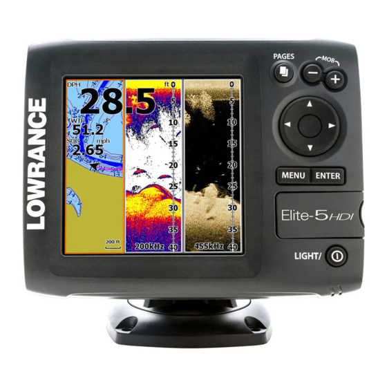
Summary of Contents for Lowrance Elite-5
- Page 1 Elite-5 & Elite-7 Combo Installation & Operation Operation manual manual...
- Page 2 Part 15.103 of the FCC rules • complies with CE under RTTE directive 1999/5/EC • complies with the requirements of level 2 devices of the Radiocommunications (Electromagnetic Compatibility) standard 2008 For more information please refer to our website: www.lowrance.com.
- Page 3 Warning The user is cautioned that any changes or modifications not expressly approved by the party responsible for compliance could void the user’s authority to operate the equipment. This equipment has been tested and found to comply with the limits for a Class B digital device, pursuant to Part 15 of the FCC rules. These limits are designed to provide reasonable protection against harmful interference in a residential installation.
-
Page 4: Table Of Contents
Trackback ..........16 Fishing Modes ......... 8 CHIRP ........... 16 Cursor ............9 Sensitivity ..........18 Goto cursor ..........9 Colorline ..........18 Advanced Mode ........10 Range ............ 19 Standby mode ........10 Table of Contents | Elite-5 & Elite-7... - Page 5 Chart Operation ......31 NMEA 0183 Output........ 49 Waypoints, Routes, Trails ...... 32 NMEA 2000 (Elite-7 units only)....49 Routes Screen ........33 Specifications ........ 51 Trails Screen ......... 37 Index ..........52 Orientation ..........39 Table of Contents | Elite-5 & Elite-7...
-
Page 6: Introduction
Select GPS from the System settings use mapping data (See illustration on page 2) Selecting a menu. Highlight GPS source and press enTer. Select the desired Source source. Introduction | Elite-5 & Elite-7... -
Page 7: Inserting Microsd Cards
To remove, carefully push in the card until it clicks out of place. Conventional Downscan Refer to the Sonar Operation section for information about conventional sonar features and settings. Downscan features and settings are covered in the Downscan Operation section. Introduction | Elite-5 & Elite-7... -
Page 8: Basic Operation
Pages menus that can only be accessed when those pag- es are displayed. This unit has eight pages: Steer, Downscan, Sonar, Chart, Chart/Sonar, Chart/Downscan, Sonar/ Downscan and Chart/Sonar/Downscan. Steer menu Pages dialog Steer page Basic Operation | Elite-5 & Elite-7... -
Page 9: Accessing The Settings Menu
Press the PagES key twice to switch active panels. The page menu for active page will be displayed when the MEnu key is pressed. accessing the Settings menu Sonar page Sonar menu Chart menu Chart page Basic Operation | Elite-5 & Elite-7... -
Page 10: Accessing Menu Items
Select the scrollbar and press the user. Depending on the type of keypad left (decrease) or right entry, different methods are used (increase). to confirm, cancel or close the dialog. Basic Operation | Elite-5 & Elite-7... -
Page 11: Fishing Modes
1. Use the keypad to select the desired character and press EntEr. 2. Repeat Step 1 for each character. 3. When entry is completed, highlight OK and press EntEr. Switches letters to uppercase/ lowercase Switches keyboard between Alpha and QWERTY layout Basic Operation | Elite-5 & Elite-7... -
Page 12: Cursor
2. Select Goto cursor and press EntEr. Water 400ft or less Ice fishing NOTE: Use Fresh Water mode when fishing in less than 100 feet of water; otherwise your unit may not track bottom properly. Basic Operation | Elite-5 & Elite-7... -
Page 13: Advanced Mode
• NMEA 0183 Output • Units (Enables distance, speed, depth, restore defaults temperature, and bearings options) Resets unit options settings to defaults. Standby mode Lowers power consumption by turning off sonar and the display. Basic Operation | Elite-5 & Elite-7... -
Page 14: Steer Page
Displays the water column moving from right to The Steer page has a compass that shows your left on your unit’s screen. current track, the direction to your destination, and a digital data navigation panel. Pages | Elite-5 & Elite-7... -
Page 15: Downscan Page
By default, the map is shown from a birds- by selecting Downscan Overlay on the Sonar eye view with North at the top of the screen. settings menu. Pages | Elite-5 & Elite-7... -
Page 16: Combo Pages
You can adjust the panel size of combo pages and control how the pages will be arranged on the screen: vertically (side) or Chart/Sonar Chart/Downscan horizontally (over). Sonar/Downscan Chart/Sonar/Downscan NOTE: Press the PagES key twice to switch active panels. Pages | Elite-5 & Elite-7... -
Page 17: Overlay Data
6. Select the desired data and press ENTEr. 7. Press MENu and select Return to Overlays. Press ENTEr. Configure 8. Press MENu, select Done Configuring Allows you to select/customize overlay data. and press ENTEr. Pages | Elite-5 & Elite-7... - Page 18 2. Select the data type and press the menu will appear. keypad to the right. 3. Highlight the desired data source and Data sources press ENTEr. Used to select the network device that will supply source data for a selected data type. Pages | Elite-5 & Elite-7...
-
Page 19: Sonar Operation
This unit supports High CHIRP, Medium CHIRP and You can review your recent sonar history by mov- Low CHIRP, depending on the transducer. ing the cursor to the left until the screen starts to move in reverse. Sonar Operation | Elite-5 & Elite-7... -
Page 20: Sonar Menu
You can use CHIRP with Lowrance conventional sonar transducers. • 50/200 kHz (Low/High CHIRP) • 83/200 kHz (Medium/High CHIRP) CHIRP Setup 1. Select a CHIRP transducer type from the Transducer type menu 2. Select the desired CHIRP frequency from the Frequency menu... -
Page 21: Sensitivity
Auto Sensitivity Keeps sensitivity at a level that works well under Adjust most conditions, reducing the needs for adjust- ments. Auto Sensitivity is turned on by default. Used to make adjustments to Sensitivity and Colorline. Sonar Operation | Elite-5 & Elite-7... -
Page 22: Range
Low CHIRP, Medium CHIRP view a section of the water column that does not and High CHIRP. include the water surface. Upper and lower limits must be at least 6.5 ft (2 m) apart. Sonar Operation | Elite-5 & Elite-7... -
Page 23: Ping Speed
Provides the best depth pen- Low CHIRP etration with lower resolu- tion images Better depth penetration Medium CHIRP than High CHIRP with minimal loss of target separation Better resolution in shallow High CHIRP water than Medium CHIRP Sonar Operation | Elite-5 & Elite-7... -
Page 24: Sonar Options
(boat pumps, water conditions, engine Color ignition systems, etc.) has on your display, and then filters out undesired signals. Allows you to change the look of the display using palettes with varying degrees of color/brightness. Sonar Operation | Elite-5 & Elite-7... -
Page 25: Fish Id
You can make adjustments to Downscan overlay settings from the sonar page. Downscan options are covered in more detail in the DSI section. nOTe: Sonar history will not be recorded when sonar is stopped. Sonar Operation | Elite-5 & Elite-7... -
Page 26: Sonar Settings
Allows you to select data to Only adjustments made to conventional sonar be displayed on top of the settings will be visible on the sonar page. Sonar page. Overlay data setup is covered in the Pages section. Overlay data Sonar Operation | Elite-5 & Elite-7... -
Page 27: Fishing Mode
That allows the display to continue smooth scrolling if the bottom depth is out of transducer range. WARnInG: Manual mode should only be used by advanced sonar users. Sonar Operation | Elite-5 & Elite-7... -
Page 28: Installation
Before setting keel offset, measure Reset water distance Reset Water Distance to zero. Transducer Type Transducer Selects the type of transducer model attached to Keel your unit. Keel Offset (-3.5 feet) Sonar Operation | Elite-5 & Elite-7... -
Page 29: Dsi Operation
You can review your sonar history by pressing the keypad to the left until the screen starts to move in reverse and the sonar history bar appears at the bottom of the screen. DSI history bar Stops sonar transmission; pauses sonar scroll DSI Operation | Elite-5 & Elite-7... - Page 30 DSI units. Adjust Accesses the Contrast adjustment Range scrollbar, allowing you to adjust contrast settings. Range settings display the section of the water column from the water surface to the selected depth range. DSI Operation | Elite-5 & Elite-7...
-
Page 31: Ping Speed
Upper and lower limits must be at least 6.5 ft (2m) Downscan options apart. nOTe: When using a custom range, you may not receive any digital depth readings, or you may receive incorrect depth information. Downscan options DSI Operation | Elite-5 & Elite-7... - Page 32 Purple is useful for viewing surface. structure detail and determining bottom hardness. Sepia is best for looking at bottom detail. Surface Clarity Surface Clarity set to Low. set to High. DSI Operation | Elite-5 & Elite-7...
- Page 33 You can record sonar data and save the file on a microSD card inserted into the unit’s card reader. Controls the quality of sonar logs. Higher quality logs will use more memory. View previously saved sonar logs DSI Operation | Elite-5 & Elite-7...
-
Page 34: Chart Operation
When the cursor is on the screen, waypoints will be saved at the cursor position; conversely, if the cursor is not displayed onscreen, waypoints will be saved at your current position. Chart Operation | Elite-5 & Elite-7... -
Page 35: Waypoints, Routes, Trails
Press the keypad left/right to toggle between waypoint, routes and trails tabs. Waypoints Waypoints Screen menu Waypoints menu Edit Allows you to edit the name, icon and latitude/longitude. of a selected waypoint. Chart Operation | Elite-5 & Elite-7... -
Page 36: Routes Screen
Delete is used to delete a tion new points on the chart. You also can add way- selected waypoint. Delete points to a route by selecting them from the chart All deletes all waypoints. screen. Chart Operation | Elite-5 & Elite-7... - Page 37 Menu, select Stop Editing and press enTeR. 3. Press the keypad down to select the Leg Name field and press enTeR. 9. Select Save and press enTeR. 4. Press Menu, select Add to End and press enTeR. Chart Operation | Elite-5 & Elite-7...
- Page 38 Press enTeR. 6. Highlight the Save button and press enTeR. Navigating a route Routes can be navigated in forward Routes menu or reverse. 1. Select the desired route on the Route screen and press Menu. Chart Operation | Elite-5 & Elite-7...
- Page 39 Delete and Delete All To edit/create a route, use the keypad to select the Route Delete is used to delete Leg Name field and press individual routes. Delete enTeR All, removes all routes. Chart Operation | Elite-5 & Elite-7...
-
Page 40: Trails Screen
When creating a trail you can customize the trail To create a trail: name and color from the New Trail. 1. Select New and press enTeR. The New Trail dialog will appear. 2. Select Save and press enTeR. Chart Operation | Elite-5 & Elite-7... - Page 41 Navigating a route segment. on map Edit Trails menu Displayed and Record Displayed allows you to show/hide trails on the map display, preventing the screen from being cluttered with trails. Chart Operation | Elite-5 & Elite-7...
-
Page 42: Orientation
All removes all trails. Overlay data Orientation Overlay data setup is covered in the Pages section. Allows you to select North Up or Course Over Ground (COG) as the map orientation. Settings Accesses the Chart settings menu. Chart Operation | Elite-5 & Elite-7... -
Page 43: Chart Settings
Chart Settings menu longitude scale. Chart Data Selects map data that will be used on the Chart display (Lowrance or Navionics regional map). Go to Navionics.com to see a full selection of available charts. Chart Operation | Elite-5 & Elite-7... -
Page 44: Navigation Settings
EGNOS. cluttered with waypoints, routes and/or trails. Waypoints, Routes, Trails Accesses the Waypoints, Routes & Trails screen. Waypoints, Routes and Trails are covered in the Chart section. Navigation Settings menu Chart Operation | Elite-5 & Elite-7... -
Page 45: Arrival Radius
Bearings Controls whether bearing will be calculated using True North or Magnetic North. Magnetic North should be used when navigating with a compass course or heading; otherwise use the default set- ting, True North. Chart Operation | Elite-5 & Elite-7... -
Page 46: Ais
4. Select the same Baud rate used by your AIS device. 5. Select Save. AIS Setup Before using AIS, your unit must be set to the same Baud rate as your AIS device. AIS | Elite-5 & Elite-7... -
Page 47: Target Symbols
You can hide all targets, or filter the target icons defined as lost. based on distance and vessel speed. Lost AIS target The target symbol represents the last valid position of the target before the reception of data was lost. AIS | Elite-5 & Elite-7... -
Page 48: Viewing Ais Target Information
MMSI number or vessel name (if available) will be displayed. You can view detailed informa- tion about a target by selecting the target and pressing EN- TEr. The AIS Vessel detail dia- log will appear. AIS | Elite-5 & Elite-7... -
Page 49: Settings
Adjusts unit settings like language, mute audio Settings menu and advanced mode. Accesses installation and configuration settings for your unit. Enables advanced features and settings System menu Settings (Advanced mode Displays software menu only) information (Elite-7 units only) (Advanced mode only) Settings | Elite-5 & Elite-7... - Page 50 Switches the unit back to default settings. Monitors the location of satellites in view and the Browse Files quality of the unit’s satellite lock-on. Allows you to view a list of the files saved to the microSD card. Settings | Elite-5 & Elite-7...
-
Page 51: Alarms
Fish ID symbol accessing the About screen. appears on display Lowrance periodically updates unit software to add features and improve functionality. To see the latest available software version go to www. lowrance.com. -
Page 52: Nmea 0183 Output
GPS antenna on the network as the unit is in basic or advanced mode. your GPS source, and share newly created way- points with other display units on the network. Basic Mode Advanced Mode Settings | Elite-5 & Elite-7... - Page 53 Data sources (Elite-7 units only) Allows you to select the source this unit will use for GPS data. Device list (Elite-7 units only) Used to view data for devices connected to your NMEA 2000 network. Settings | Elite-5 & Elite-7...
-
Page 54: Specifications
300ft (91 m) 455/800Khz Case Size bracket Max depth 1000ft (305 m) 83/200kHz Elite-5: 5.4” H (136 mm) x 6.9” W (174 2500ft (762 m) 50/200kHz mm); 5.9” H (151 mm) with bracket 455/800 kHz Elite-7: (7” diagonal) 16-bit color Full... -
Page 55: Index
Auto Sensitivity 18 Custom Range 19, 28 Language 47 Low CHIRP 20 Goto cursor 9 Bearings 42 Data Port 47 Goto waypoint 33 Browse Files 47 Depth Range 27 GPS Source 47 Magnetic Variation 42 Index | Elite-5 & Elite-7... - Page 56 NMEA 2000 49 Route display 41 Data sources 50 Routes Screen 33 Noise Rejection 21, 29 Temp calibration 25 Text entry 8 Saving Screenshots 48 Time 47 Off Course alarm 49 Scrollbars 7 Off Course Distance 42 Index | Elite-5 & Elite-7...
- Page 57 Databases Limited Warranty Navico Databases License Agreement “We”, “our”, or “us” refers to Navico, the manufacturer of this product. “You” or “your” THIS IS A LEGAL AGREEMENT BETWEEN THE END-USER WHO FIRST PURCHASES refers to the first person who purchases the product as a consumer item for personal, family, or THIS PRODUCT AS A CONSUMER ITEM FOR PERSONAL, FAMILY, OR HOUSEHOLD household use.
- Page 58 Contact information Customer Service: 1-800-628-4487 (8 a.m. to 5 p.m. Central Standard Time, M-F) (Canada) 1-855-361-1564 canada@navico.com (8 a.m. to 5 p.m. Eastern Standard Time, M-F) Ordering Accessories http://store.navico.com/ Visit our website www.lowrance.com...
- Page 59 Visit our website: www.lowrance.com *988-10647-001*...