Garmin GPSMAP 180 Specifications
Hide thumbs
Also See for GPSMAP 180:
- Owner's manual (97 pages) ,
- Owner's manual (96 pages) ,
- Owner's manual and reference manual (96 pages)
Advertisement
Quick Links
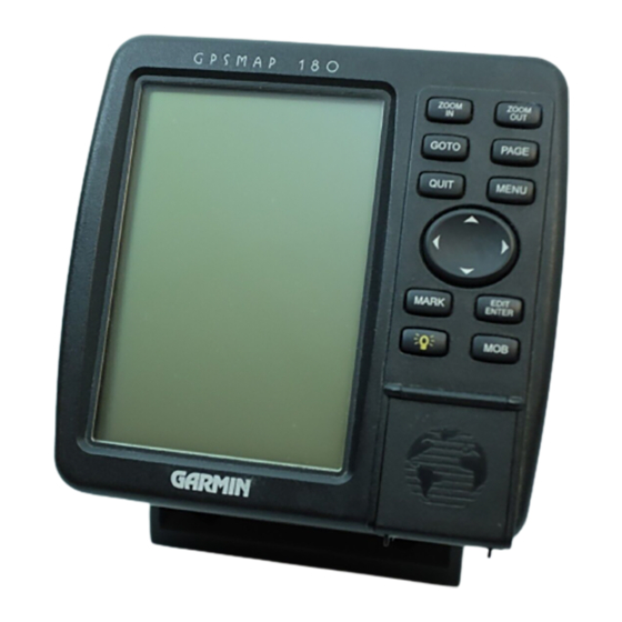
GPSMAP 180
A Perfect Fit for Every Mariner
The new GARMIN GPSMAP 180 offers boaters the latest GPS
technology on a 5.5" diagonal display that's a perfect combination
of outstanding GPS accuracy and easy-reading plotter graphics.
Add in simple, menu-driven operation, micro G-chart
cartography, and a powerful 12 parallel channel GPS receiver, and
you get a GPS chartplotter that's ideal for many mariners.
The GPSMAP 180 boasts an impressive set of navigation features
like user-selectable data fields, simple point-and-shoot waypoint
and route creation, fuel and trip planning, GARMIN's exclusive
TracBack
TM
track log navigation, one-button map scale selection
and straightforward map panning using the rocker keypad. It even
comes complete with a surface/flush mount bracket that makes
installation down right easy — in the bulkhead or at the helm.
The GPSMAP 180 is ready to fit your application.
12 parallel channel receiver tracks and uses up to 12 satellites
for fast, accurate positioning.
Simple, menu-driven operation with 'point and shoot'
creation of waypoints and routes.
cartridge
TM
5.5" diagonal, 4-level gray display with crisp graphics, track
up plotting, full-featured zooming and panning capability,
backlighting of keys and display for night time operation.
Graphic highway provides steering guidance with user
selectable view, data fields and waypoint display options.
Built-in worldwide background map, accepts optional
micro G-chart
offshore cartography sealed in a datacard cavity.
Exclusive TracBack
to port without manually entering waypoints.
TM
cartridges with inland water or Navionics
feature lets you quickly navigate back
TM
®
Advertisement

Related Manuals for Garmin GPSMAP 180


Summary of Contents for Garmin GPSMAP 180
- Page 1 12 parallel channel receiver tracks and uses up to 12 satellites A Perfect Fit for Every Mariner for fast, accurate positioning. The new GARMIN GPSMAP 180 offers boaters the latest GPS Simple, menu-driven operation with ‘point and shoot’ technology on a 5.5" diagonal display that’s a perfect combination creation of waypoints and routes.
- Page 2 5º F to 158º F Map Datums: (-15º C to 70º C) Coordinates: Lat/Lon, UTM/UPS, plus 7 grids, including Maidenhead Accessories Standard: GPSMAP 180 Chartplotting Receiver Performance Remote Antenna with 30' Cable Receiver: Differential-ready 12 parallel Power/Data Cable channel receiver tracks all User’s Manual...