Table of Contents
Advertisement
Advertisement
Table of Contents

Related Manuals for Garmin DriveAssist 51


Summary of Contents for Garmin DriveAssist 51
- Page 1 GARMIN DRIVEASSIST ™ Owner’s manual...
- Page 2 © 2017 Garmin Ltd. or its subsidiaries All rights reserved. Under the copyright laws, this manual may not be copied, in whole or in part, without the written consent of Garmin. Garmin reserves the right to change or improve its products and to make changes in the content of this manual without obligation to notify any person or organisation of such changes or improvements.
-
Page 3: Table Of Contents
Viewing Foursquare location details ........11 Garmin® VIRB® App ..............3 Checking in with Foursquare ..........11 Viewing Videos and Photos in the Garmin VIRB App .... 3 TripAdvisor® ................11 Videos and photos on your computer ......... 3 Finding TripAdvisor points of interest ........12 Deleting a video or photo ............ - Page 4 Enabling traffic ................18 Updating Maps and Software Using a Wi‑Fi Network ..24 Viewing traffic on the map ............18 Updating Maps and Software with Garmin Express .... 24 Searching for traffic incidents ..........18 Device Care ................24 Voice Command ............
-
Page 5: Getting Started
• Update the maps and software on your device (Updating Press it in until it clicks. Maps and Software with Garmin Express, page 24). • Mount the device in your vehicle and connect it to power Mounting and Powering the Device in Your... -
Page 6: Acquiring Gps Signals
GPS signal status. Hold to view GPS accuracy and acquired satellite information (Viewing GPS signal status, page 26). Some features, such as advanced driver assistance and Garmin Real Vision features, may not perform properly if the camera is ™ Bluetooth ®... -
Page 7: Taking A Photo
® ® saved. The free Garmin VIRB app allows you to view and share The memory card has limited storage. After you save a video recorded dash cam videos and photos on your smartphone. To recording, you should transfer the recording to your computer or... -
Page 8: Enabling Or Disabling Audible Driver Alerts
Speed limit exceeded: the device plays a tone and displays a red border on the speed limit icon when you exceed the Your Garmin DriveAssist device uses built-in sensors to detect a posted speed limit for the current road. possible vehicle incident. -
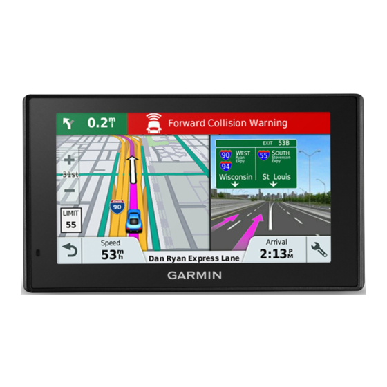
Page 9: Advanced Driver Assistance System
For more information, go to garmin.com distance and your vehicle has remained stopped. This can be /warnings. -
Page 10: Navigating To Your Destination
• The LDWS feature may not detect lane departures on Your route on the map extremely wide, narrow or winding roads. As you travel, the device guides you to your destination using voice prompts and information on the map. Instructions for your next turn or exit, or other actions appear across the top of the Navigating to your destination map. -
Page 11: Arriving At Your Destination
(optional). • Where available, the Garmin Real Vision feature overlays the NOTE: detailed parking data is not available in all areas or location of your destination on a real-time image of your for all parking locations. -
Page 12: Changing Your Active Route
• On your Garmin DriveAssist device, select Apps > Last Spot • To add more shaping points to the route, select additional > Go!. locations on the map. • On your watch, start the Watch Link app, select Find My Car, •... -
Page 13: Avoiding Toll Stickers
Select an option: Select the lower right corner of the area to avoid and select Next. NOTE: the menu changes based on your area and the map data on your device. The selected area is shaded on the map. • Select Toll Roads. Select Done. -
Page 14: Finding A Location By Category
You can view a list of all points of interest located within each Parking venue. Your Garmin DriveAssist device includes detailed parking data, Select a venue. which can help you find nearby parking based on the likelihood of available parking spots, type of parking area, price, or Select >... -
Page 15: Finding Parking Near Your Current Location
In some areas, live parking data is available while your Garmin Select an option: DriveAssist device is connected to Smartphone Link (Pairing • Select a town from the list of nearby towns. with your phone and connecting to Smartphone Link, •... -
Page 16: Finding Tripadvisor Points Of Interest
for applicable points of interest. You can also search for nearby Saving Locations TripAdvisor points of interest and sort by distance or popularity. Saving a location Finding TripAdvisor points of interest Search for a location (Finding a location by category, Select Where To? >... -
Page 17: Map Tools
• To switch between North Up and 3-D views, select . Viewing upcoming locations From the map, select > Up Ahead. • To filter the displayed points of interest by category, select Select an option: • To start a route, select a location on the map, and select •... -
Page 18: Viewing Upcoming Traffic
The traffic map shows colour-coded traffic flow and delays on Watch Link: provides pedestrian navigation guidance to your nearby roads. destination or to your parking spot using a compatible Garmin From the main menu, select Apps > Traffic. watch with Connect IQ (Watch Link, page 19). -
Page 19: Garmin Live Services
Garmin Live Services (Bluetooth Feature status icons, page 14). Before you can use Garmin Live Services, your device must be Receiving notifications connected to Smartphone Link (Pairing with your phone and connecting to Smartphone Link, page 14). -
Page 20: Viewing The List Of Notifications
Placing a call Apple device Before you can connect to the Smartphone Link app, you must Dialling a number pair and connect your Garmin DriveAssist device with your Select Apps > Phone > Dial. phone. Enter the number. If you did not connect to the Smartphone Link app during the Select Dial. -
Page 21: Setting Up Bluetooth Features For Your Smartphone With Android
Setting up Bluetooth features for your NOTICE smartphone with Android ™ Garmin is not responsible for the accuracy or timeliness of the By default, all compatible Bluetooth features are enabled when traffic information. you pair your phone. You can enable, disable, or customise certain features. -
Page 22: Traffic Receiver Subscriptions
A regional traffic data subscription is included with most traffic Activating voice command receivers. You can add subscriptions for additional regions to your traffic receiver. For more information, go to garmin.com Say your wake-up phrase. /traffic. The voice command menu appears. -
Page 23: Using The Apps
Garmin DriveAssist device. You can choose which alerts appear on your watch. Stopping LiveTrack Sharing You can stop LiveTrack sharing at any time using your Garmin On your Garmin DriveAssist device, select Apps > Watch DriveAssist device or the Smartphone Link app. -
Page 24: Viewing The Weather Forecast
• On your smartphone, open the Smartphone Link app, and Planning a trip select LiveTrack > Stop LiveTrack. A trip can include many locations, and it must include at least a starting point and a destination. The starting point is the location Viewers receive a message that the LiveTrack session has from which you plan to start your trip. -
Page 25: Editing And Saving Your Active Route
Auto Zoom: automatically selects the zoom level for optimal use Smartphone Link, and you must have a subscription to the of your map. When disabled, you must zoom in or out photoLive service (Subscribing to Garmin Live Services, manually. page 15). -
Page 26: Dash Cam Settings
Record After Power Loss: continues recording video up to a selected time period after external power is lost. The babyCam settings allow you to manage paired Garmin babyCam ™ cameras and camera settings. This menu appears Wireless network settings on your navigation device only when the device is connected to a wireless camera receiver cable. -
Page 27: Units And Time Settings
Keyboard Language: enables keyboard languages. You can purchase an approved Garmin AC-DC adapter suitable for home or office use from a Garmin dealer or Proximity alerts settings www.garmin.com. The device may charge slowly when NOTE: you must have custom points of interest (POIs) loaded connected to a third-party adapter. -
Page 28: Updating Maps And Software Using A Wi-Fi Network
Updating Maps and Software with Garmin Express Do not expose the device to water. You can use the Garmin Express application to download and install the latest map and software updates for your device. Cleaning the camera lens... -
Page 29: Cleaning The Outer Casing
(Installing the dash camera memory card, page 1). Your device • Register your device using the Garmin Express software detects memory card errors automatically and alerts you when it (garmin.com/express). is time to replace your memory card. -
Page 30: The Device Does Not Charge In My Vehicle
Garmin mapping software The Bluetooth option must be enabled. (www.garmin.com). In addition to map and data storage, the memory card can be used to store files such as maps, images, • Enable Bluetooth wireless technology on your phone and geocaches, routes, waypoints, and custom POIs. -
Page 31: Purchasing Accessories
Click the Maps tab. Follow the on-screen instructions. Purchasing accessories Go to garmin.com/accessories. Appendix... -
Page 32: Index
23, 26 fuse, changing 25 next turn 6 maximising 26 notifications 14–17 problems 26 Bluetooth technology 14, 16, 26 Garmin Connect 14 disconnecting a device 17 Garmin Express, updating software 24 off-road navigation 9 pairing a phone 14 Garmin Live Services 15 on-screen buttons 2 settings 22 subscribing 15 owner's manual 19 Bluetooth Technology 14 Garmin Real Vision 7... - Page 33 Smartphone Link 14–17 connecting 14, 16, 17 disabling calls 16, 17 software updating 23, 24 version 23 specifications 23 speech recognition 18 speed cameras 4 subscriptions, Garmin Live Services 15 suction cup 25 theft, avoiding 25 time settings 23 tolls, avoiding 8 tools, maps 13 traffic 14, 17, 18, 22 adding subscriptions 18 alternative route 8...
- Page 34 September 2018 190-02120-00_0C...