Garmin GNS 430 Operating Manual
Friendlypanels gps for microsoft fs9 & fsx
Hide thumbs
Also See for GNS 430:
- Pilot's manual & reference (267 pages) ,
- Pilot's manual and reference (234 pages) ,
- Quick reference (23 pages)
Advertisement
FriendlyPanels Software
WARNING
This operating manual has been writen following the original GARMIN GNS 430/430A
Pilot's Guide and Reference, but it's not intended to be valid for training purposes other
®
than its use with Microsoft
Flight Simulator 2004. We consider very interesting to read
the original GARMIN GNS 430/430A Pilot's Guide and Reference in order to know this
wonderful GPS better.
FriendlyPanels
www.friendlypanels.net
fpanels@friendlypanels.net
Advertisement
Table of Contents

Related Manuals for Garmin GNS 430


Summary of Contents for Garmin GNS 430
- Page 1 Pilot’s Guide and Reference, but it's not intended to be valid for training purposes other ® than its use with Microsoft Flight Simulator 2004. We consider very interesting to read the original GARMIN GNS 430/430A Pilot’s Guide and Reference in order to know this wonderful GPS better. FriendlyPanels www.friendlypanels.net...
-
Page 2: Table Of Contents
TABLE OF CONTENTS 1. MOUSE CLICKING AREAS 2. COMMUNICATING USING THE GNS 530 3. MAIN PAGE GROUPS 3.1 NAV PAGE GROUP 3.2 WPT PAGE GROUP 3.3 NRST PAGE GROUP 3.4 AUX PAGE GROUP 3.5 DIRECT-TO NAVIGATION 3.6 FLIGHT PLANS 3.7 PROCEDURES... -
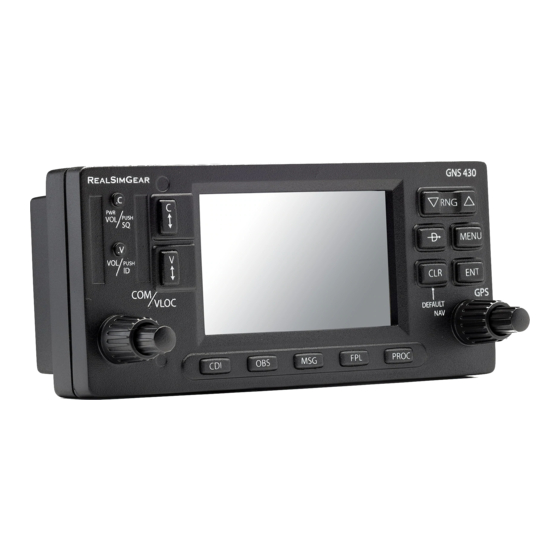
Page 3: Mouse Clicking Areas
5. Small left knob: TUNE RADIO NAV OR COM FRACTAL FIGURES. 6. The GNS 430’s CDI Key is used to couple the GPS or VLOC receiver to the external CDI (or HSI). When the external CDI (or HSI) is being driven by the GPS receiver, ‘GPS’... - Page 4 17. The MENU Key displays a context-sensitive list of options. This option list allows the pilot to access additional features or make setting changes which relate to the currently displayed page. 18. The RNG Key allows the pilot to select the desired map range. 19.
-
Page 5: Communicating Using The Gns 530
2. COMMUNICATING BY USING THE GNS 430 A frequency may be quickly selected from the database by simply highlighting the desired frequency on any of the main pages and pressing the ENT Key. This process is referred to as auto-tuning. Once a frequency is selected in the standby field, it may be transferred to the active frequency by pressing the COM Flip-flop Key. -
Page 6: Main
3. MAIN PAGE GROUPS The GNS 430’s main pages are divided into four separate page groups: NAV, WPT, NRST and AUX. Each page group consists of multiple pages. The page groups are selected by using the large right knob. The individual pages are selected by using the small right knob. - Page 7 • Bearing to destination (BRG) • Course to steer (CTS) • Cross track error (XTK) • Desired track (DTK) • Distance to destination (DIS) • Estimated time of arrival (ETA) • Estimate time enroute (ETE) • Ground speed (GS) • Ground track (TRK) •...
- Page 8 MAP PAGE The second NAV page is the Map Page, which displays the present position using an airplane symbol, along with nearby airports, NAVAIDS and airspace boundaries. To select a map range: 1. Press the up arrow of the RNG Key to zoom out to a larger map area. 2.
- Page 9 Map Panning Another Map Page function is panning, which allows the map to move beyond its current limits without adjusting the map range when map orientation is North Up. When the panning function is selected (by pressing the small right knob while map orientation is North Up), large and small right knob is used to move the map left or right and up or down.
- Page 10 Restoring Factory Settings ‘Restore Defaults?’ resets all four user-selectable data fields to their original factory default settings. Use large right knob to select ‘Restore Defaults?’ and press ENT. TERRAIN PAGE The TERRAIN Page is the third page in the NAV PageGroup. To display the TERRAIN Page, select the NAV Page Group and turn the small right knob until the TERRAIN Page is displayed.
- Page 11 POSITION PAGE The Position Page (the fifth NAV page) displays the present position default, in latitude, longitude and altitude. The Position Page also displays the current track, ground speed, time, and a reference waypoint field. These fields are user-selectable to configure the page to the pilot’s own preferences and current navigation needs.
- Page 12 Changing Reference Waypoint User can change the reference waypoint in the bottom side and also TO or FROM it. Use large right knob and press ENT. SATELLITE STATUS PAGE This is a dummy page. VERTICAL NAVIGATION PAGE The Vertical Navigation Page (the seventh NAV page) displays data showed below. AP Target Altitude Above MSL Distance to reach...
-
Page 13: Wpt
3.2 WPT PAGE GROUP This second page group provides information for thousands of airports, VORs, NDBs, intersections, runways, frequencies, and procedures. To quickly select a WPT page: 1. From any page, press and hold the CLR Key to select the Default NAV Page. 2. - Page 14 AIRPORT LOCATION PAGE 1. Position (Latitude/Longitude) 2. Facility Name and Location (City) 3. Radar Coverage 4. Airport Identifier, Symbol, and Type 5. Field Elevation and Available Fuels 6. Airspace Type 7. Best Available Approach 8. Current Page Group 9. Position of Current Page within Current 10.
- Page 15 AIRPORT FREQUENCY PAGE Airport Identifier, Frequency Type Frequency Symbol and Type Scroll bar Current Page Group Position of Current Page Within Current Page Group The Airport Frequency Page displays radio frequencies and frequency types for the selected airport. To scroll through the frequency list and tune to a desired frequency on the list: 1.
- Page 16 INTERSECTION PAGE The Intersection Page displays the latitude, longitude and region for the selected intersection. The Intersection Page also displays the identifier, radial, and distance from the nearest VOR, VORTAC, or VOR/DME. Latitude/Longitude Intersection Identifier Postition and Symbol Nearest VOR and Symbol Radial and Distance...
- Page 17 VOR PAGE The VOR Page displays the facility name, city, region, magnetic variation, latitude, and longitude for the selected VOR. The VOR Page also displays the frequency and a weather broadcast indication (if applicable). Latitude/Longitude VOR Identifier Facility Name, Postition and Symbol City, and Region Magnetic...
-
Page 18: Nrst
4. Press the small right knob to remove the flashing cursor. Navigating to a Nearby Waypoint The NRST pages can be used in conjunction with the GNS 430’s direct-to function to quickly set a course to a nearby facility. This feature can be a real time saver compared to retrieving information from the database using the WPT pages. - Page 19 NEAREST AIRPORT PAGE Best Available Airport Identifier Approach Symbol, Bearing To, and Distance To Tower or CTAF Frequency and Longest Runway The Nearest Airport Page displays the identifier, symbol, bearing, and distance to the nine nearest airports (within 200 nm of the present position). For each airport listed, the Nearest Airport Page also indicates the best available approach, common traffic advisory frequency (CTAF), and the length of the longest runway.
- Page 20 NEAREST NDB PAGE The nearest NDB Page displays the identifier, symbol, bearing, distance, and frequency to the nine nearest NDBs (within 200 nm of the present position). To view additional information for a nearby NDB, start from the nearest NDB Page and follow the preceding steps 2 through 4.
-
Page 21: Aux
3.4 AUX PAGE GROUP The AUX pages also provide functions such as fuel planning, density altitude, true airspeed, and winds aloft calculations To quickly select an AUX page: 1. From any page, press and hold the CLR Key to select the Default NAV Page 2. - Page 22 The following menu options are available: • Fuel Planning - This option displays current fuel conditions along the active direct-to or flight plan. Press CLR key to return to FLIGHT PLANNING menu page from this page. The following information is provided: •...
- Page 23 The following information is provided: • IND ALT - Indicated altitude • CAS - Calibrated airspeed • BARO - Barometric pressure • DEN ALT - Density altitude • TAS - True airspeed • WIND - Wind direction and speed • HEAD/TAIL WIND - Magnitude of head wind or tail wind component UTILITY PAGE The Utility Page provides access (via ‘menu options’) to Flight Timers which leads to...
-
Page 24: Direct-To Navigation
3.5 DIRECT-TO NAVIGATION The GNS 430’s direct-to function provides a quick method of setting a course to a destination waypoint. Once a direct-to is activated, the GNS 430 establishes a point-to- point course line (great circle) from the present position to the selected direct-to destination. -
Page 25: Flight Plans
3.6 FLIGHT PLANS In this FreindlyPanels GNS430 version flight plans must be created by FS9 means or some external add-on. Active Flight Plan Options Access the Active Flight Plan Menu Page: 1. Press the FPL Key to view the Active Flight Plan Page. 2. -
Page 26: Procedures
3.7 PROCEDURES The Procedures Page is displayed by pressing the PROC Key. The Procedures Page provides direct access to approaches based upon the active flight plan or direct-to destination. In either case, the departure and destination airports must have published procedures associated with them. - Page 27 To activate an approach: 1. Press the PROC Key to display the Procedures Page. 2. Turn the large right knob to highlight ‘Activate Approach?’ and press the ENT Key. To activate the approach, with vectors to final: 1. Press the PROC Key to display the Procedures Page. 2.