Sign In
Upload
Manuals
Brands
Garmin Manuals
Radio
GDL 69
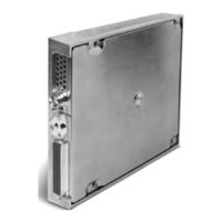
Garmin GDL 69 Manuals
Manuals and User Guides for Garmin GDL 69. We have
11
Garmin GDL 69 manuals available for free PDF download: Pilot's Manual, Pilot's Manual Addendum, Installation Manual, Activation Instructions, Instructions Manual, Manual
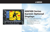
Garmin GDL 69 Pilot's Manual (78 pages)
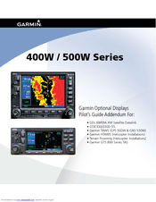
400W / 500W Series XM Satellite Datalink, TIS, TAWS, HTAWS, TAS
Brand:
Garmin
| Category:
GPS
| Size: 4.1 MB
Table of Contents
Table of Contents
4
Part One: Traffic Information Service (TIS) Interface
7
Section 1: TIS Operation and Symbology
7
TIS Operation
7
How TIS Differs from TCAS
8
TIS Limitations
8
Improving TIS
9
TIS Symbology
9
Section 2: Control and Display
11
TIS Traffic Display Status and Pilot Response
11
Traffic Page
12
Traffic Page Display Range
12
Map Page
13
Configuring TIS Traffic Data on the Map Page
13
Highlighting TIS Traffic Using Map Page Panning
14
Section 3: TIS Operational Procedures
15
Introduction
15
Power-Up Test
15
Manual Override
16
Flight Procedures
16
After Landing
16
Part Two: XM Radio Interface
17
Section 1: Introduction
17
Overview
17
XM Radio Pages
17
XM NAV Pages
17
XM WPT Pages
18
XM AUX Pages
18
Section 2: XM Weather
18
Weather Product Age
19
XM NEXRAD Weather
19
NEXRAD U.S. and Canadian Coverage
20
NEXRAD Intensity
21
NEXRAD Abnormalities
21
NEXRAD Limitations
22
XM Weather Metars
22
Textual METAR Page
24
Textual METAR/TAF Code
25
TAF Page
25
TFR Information
25
Lightning (LTNG)
26
Cell Movement (CELL MOVE)
27
Winds Aloft
28
Winds Aloft Altitude
29
Section 3: XM AUX Pages
29
XM Information Page
29
XM WX Timestamps
30
Section 4: XM Audio
31
XM Audio Menu
33
Add to Presets List
33
Enter Channel Number
34
Display Channel in List
34
Display Artist in List
35
Display Title in List
35
Enable/Mute Audio Output
36
Change Volume
36
Part Three: TAWS Interface
37
Section 1: Introduction
37
Overview
37
Operating Criteria
37
Limitations
37
Section 2: TAWS Operation
38
TAWS Alerting
38
Baro-Corrected Altitude
38
Power up
38
TAWS Page
38
Inhibit Mode
40
External TAWS Inhibit Control
40
TAWS Manual Test
40
TAWS Symbols
41
General Database Information
42
Database Versions
42
Database Updates
43
Terrain/Obstacle Database Areas of Coverage
43
Section 3: TAWS Alerts
44
Forward Looking Terrain Avoidance
44
Premature Descent Alerting (PDA)
45
Excessive Descent Rate Alert (EDR)
46
Negative Climb Rate after Takeoff Alert (NCR)
46
Five-Hundred" Aural Alert
48
TAWS Not Available Alert
48
TAWS Failure Alert
48
TAWS Alert Summary
48
Pilot Actions
50
Airport Terrain "Cutouts
50
Part Four: HTAWS Interface
51
Section 1: Introduction
51
Overview
51
Operating Criteria
51
Limitations
51
Section 2: HTAWS Operation
52
HTAWS Alerting
52
Baro-Corrected Altitude
52
Power up
52
HTAWS Page
52
Page Menu
53
Inhibit Mode
54
External HTAWS Inhibit Control
54
Reduced Protection Mode
54
Mute Active Caution
55
HTAWS Manual Test
56
HTAWS Legend
56
HTAWS Symbols
57
General Database Information
58
Database Versions
58
Database Updates
59
Terrain Database Areas of Coverage
59
Obstacle Database Areas of Coverage
60
Section 3: HTAWS Alerts
60
Forward Looking Terrain Avoidance
61
Voice Call out Aural Alert
61
HTAWS Not Available Alert
62
HTAWS Failure Alert
62
HTAWS Alert Summary
62
Pilot Actions
63
Voice Call out Selection
64
Part Five: Terrain Proximity Interface
67
Introduction
67
Displaying Terrain Proximity
67
Terrain Proximity Legend
67
Terrain Proximity 120° Arc or 360° Rings
68
Terrain Proximity Aviation Data
68
Terrain Proximity Limitations
68
190-00356-30 Rev H
68
System Status
70
Part Six: Garmin GTS 8XX Series Interface
71
Introduction
71
GTS 8XX Series Description
71
Power-Up Self-Test
71
Altitude Display Mode
71
Traffic Page
71
User-Initiated Test
72
Voice Announcements
72
Switching between Standby and Operating Modes
72
Traffic Page Display Range
72
Highlighting Traffic Data Using Map Panning
73
Traffic Warning Window
74
Description of Traffic Advisory Criteria
74
Configuring Traffic Data on the Map Page
75
Monitoring Traffic
76
Failure Response
76
Advertisement
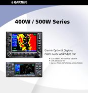
Garmin GDL 69 Pilot's Manual Addendum (76 pages)
Optional Displays, Weather Datalink, XM Satellite Datalink, TAWS, TERRAIN
Brand:
Garmin
| Category:
Avionics Display
| Size: 3.47 MB
Table of Contents
Table of Contents
4
Part One: Traffic Information Service (Tis) Interface
9
Section 1: TIS Operation and Symbology
9
TIS Operation
9
TIS Limitations
10
TIS Symbology
12
Section 2: Control and Display
13
TIS TraffiC Display Status and Pilot Response
13
TraffiC Ground Track
14
TraffiC Warning Window
14
TraffiC Page
14
TraffiC Page Display Range
14
Map Page
15
Configuring TIS TraffiC Data on the Map Page
15
Highlighting TIS TraffiC Using Map Page Panning
16
Section 3: TIS Operational Procedures
17
Introduction
17
Power-Up Test
17
Manual Override
18
Flight Procedures
18
After Landing
18
Part Two: Weather Data Link Interface
19
Section 1: Introduction
19
Weather Products
19
Section 2: NEXRAD Overview
20
NEXRAD Description
20
NEXRAD Abnormalities
20
NEXRAD Limitations
20
NEXRAD Intensity
21
Section 3: NEXRAD Operation
22
Requesting NEXRAD Data
22
Data Received Message (GDL 49 Only)
24
Displaying NEXRAD Data on the Weather Page
24
Customizing NEXRAD Data on the Weather Page
24
Displaying NEXRAD Data on the Map Page
25
Customizing NEXRAD Data on the Map Page
25
Displaying NEXRAD Data on the Default NAV Page (500 Series Only)
26
Customizing NEXRAD Data on the Default NAV Page (500 Series Only)
26
Request Shortcuts
26
Data Link Request Log Page (GDL 49 Only)
27
Sending Position Reports (GDL 49 Only)
27
Section 4: METAR Operation
28
Requesting Graphical METARS
28
Displaying Graphical METARS on the NAV Weather Page
29
Viewing Graphical METAR Data for a SpecifiC Airport from the Map Page
29
Weather Legend Page
30
Displaying Textual METARS
31
Section 5: Temperature, Dewpoints, and Winds
32
Table of Contents Displaying Temperature/Dewpoints
32
Displaying Wind Data
32
Section 6: Troubleshooting
33
Monitoring the Data Link
33
GDL 49 Datalink Status
34
GDL 69/69A Datalink Status
35
Part Three Terrain Interface
37
Section 1: Introduction
37
Overview
37
Operating Criteria
37
GPS Position and GPS-MSL Altitude
37
TERRAIN Alerting Using the GPS Position/Gps-MSL Altitude
38
Baro-Corrected Altitude Verses GPS-MSL Altitude
38
Premature Descent Alerting (PDA) Using GPS-MSL Altitude
38
Limitations
39
Section 2: TERRAIN Operation
40
Power up
40
TERRAIN Page
40
Inhibit Mode
41
TERRAIN Symbols
42
Color Interpretation
42
General Database Information
43
Database Versions
43
Database Updates
43
Terrain/Obstacle Database Areas of Coverage
44
Navigation Database
44
Nearest Airport Criteria & TERRAIN Phase of Flight
45
TERRAIN Destination Airport
45
Section 3: TERRAIN Alerts
46
Pop-Up Alerts
46
Forward Looking TERRAIN Avoidance
47
Premature Descent Alerting (PDA)
48
TERRAIN Failure Alert
49
TERRAIN Not Available' Alert
49
TERRAIN Alert Summary
50
Part Four Taws Interface
51
Section 1: Introduction
51
Overview
51
Operating Criteria
51
GPS Position and GPS-MSL Altitude
51
TAWS Alerting Using the GPS Position/Gps-MSL Altitude
52
Baro-Corrected Altitude Verses GPS-MSL Altitude
52
Premature Descent Alerting (PDA) Using GPS-MSL Altitude
52
Limitations
53
Section 2: TAWS Operation
54
Power up
54
TAWS Page
54
Inhibit Mode
56
TAWS Manual Test
57
TAWS Symbols
58
Table of Contents Color Interpretation
58
General Database Information
59
Database Versions
59
Database Updates
59
Terrain/Obstacle Database Areas of Coverage
60
Navigation Database
60
Nearest Airport Criteria & TAWS Phase of Flight
61
TAWS Destination Airport
61
Section 3: TAWS Alerts
62
Forward Looking TERRAIN Avoidance
63
Premature Descent Alerting (PDA)
64
Excessive Descent Rate Alert (EDR)
65
Negative Climb Rate after Takeoff Alert (NCR)
66
Five-Hundred' Aural Alert
67
TAWS Failure Alert
67
TAWS Not Available Alert
67
TAWS Alert Summary
68
APPENDIX A: Standard Forecast Abbreviations
71
APPENDIX B: Graphical METAR Symbology
72
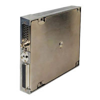
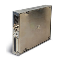
Garmin GDL 69 Installation Manual (70 pages)
XM Satellite Radio data link receiver
Brand:
Garmin
| Category:
Receiver
| Size: 2.97 MB
Table of Contents
Installation Manual
1
Table of Contents
5
1 General Description
9
Scope
9
Introduction
9
Equipment Description
9
Figure 1-1. GDL 69/69A Unit View
9
Interfaced Equipment
10
Audio Entertainment Installation Limitations
10
Table 1-1. Interfaced Equipment List
10
XM Satellite Radio
11
Interface Summary
11
Technical Specifications
12
Table 1-2. GDL 69/69A Specifications
12
Table 1-3. GA 55, GA 55A, GA 57 Specifications
12
Table 1-4. GDL 69/69A Unit Dimensions
12
Figure 1-2. GDL 69/69A Remote Rack Unit Dimensions
13
Figure 1-3. GDL 69/69A Modular Rack Unit Dimensions
13
Table 1-5. XM Antennas
14
Table 1-6. XM Satellite Radio Antenna Minimum Requirements
14
Table 1-7. GA 55, GA 55A, GA 57 XM Antenna Specifications
14
Reference Documents
15
Certification
15
Unpacking Unit
15
Warranty Statement
15
Table 1-8. Referenced Publications
15
2 Installation
17
Introduction
17
Pre-Installation Information
17
Installation Materials
17
Table 2-1. Kit Contents
17
Equipment Mounting
18
Figure 2-1. Suggested Mounting Locations for Remote Rack
18
Figure 2-2. GDL 69/69A Remote Mount Rack
19
Figure 2-3. Typical Rocker Switches
20
Figure 2-4. Modular Rack for the G1000
20
Cabling and Wiring
21
Table 2-2. Pin Contact Part Numbers
21
Table 2-3. Recommended Crimp Tools
22
Figure 2-5. Garmin Connector Assembly
23
Table 2-4. Garmin Connector Assembly
23
Figure 2-6. Backshell Assembly
24
Table 2-5. Spider Kits
25
Table 2-6. Spider Installation Required Parts
25
Figure 2-7. Spider Installation Drawing
26
XM Antenna
28
Figure 2-8. Antenna Installation Location
29
Figure 2-9. XM Signal Gain Requirements
30
Table 2-7. XM Gain/Loss Component Calculation
31
Weight and Balance
33
Electrical Load Analysis
33
Table 2-8. Unit Weights
33
Cooling Air
34
Installing/Inserting Unit
34
Figure 2-10. TNC Connector Installation
34
Figure 2-11. GDL 69/69A Installation
35
3 System Interconnects
37
Pin out List
37
Figure 3-1. Pin out
37
Table 3-1. Pin out List
37
Functional Descriptions
39
4 System Configuration/Checkout
43
Post-Installation Power Check
43
Initialization of Configuration Module
43
Configure RS-232 Port
45
System Operational Checkout
45
Figure 4-1. Data Link Configuration Page on the MX20
45
Figure 4-2. Data Link Configuration Page on the 400/500 Series
46
Figure 4-3. Configuration Upload Page - GDU 104X
46
Figure 4-4. Configuration Page - GDU 104X
46
Activation with XM Satellite Radio
47
5 Troubleshooting
49
Table 5-1. Troubleshooting Guide
49
6 Limitations
51
Operation
51
Installation
51
7 Periodic Maintenance
53
Audio Suppression
53
Equipment Calibration
53
Cleaning
53
Appendixa - Stc Data
55
Appendixb - Environment Qualification Form
57
Appendixc - Construction and Validation of Structures
59
Table C-1. Static Test Load (GDL 69 with Remote Rack
59
Table C-2. Static Test Load (GDL 69A with Remote Rack
59
Appendixd - Installation Drawings
61
Figure D-1. GDL 69 Interconnect to MFD and Audio Panel
63
Figure D-2. GDL 69 Interconnect to GDU 104X
64
Figure D-3. GDL 69 Interconnect to 400/500 Series
65
Figure D-4. GDL 69 Interconnect to MFD and 400/500 Series
66
Figure D-5. Interconnect to Warning Horns
67
Figure D-6. Optional Audio Attenuation
68
Advertisement
Garmin GDL 69 Pilot's Manual Addendum (50 pages)
400W/500W Series
Brand:
Garmin
| Category:
GPS
| Size: 2.83 MB
Table of Contents
Table of Contents
4
Part One: TraffiC Information Service (TIS) Interface
5
Section 1: TIS Operation and Symbology
5
TIS Operation
5
How TIS Differs from TCAS
6
TIS Limitations
6
Improving TIS
7
TIS Symbology
8
Section 2: Control and Display
9
TIS TraffiC Display Status and Pilot Response
9
TraffiC Page
10
TraffiC Page Display Range
10
Map Page
11
Configuring TIS TraffiC Data on the Map Page
11
Highlighting TIS TraffiC Using Map Page Panning
12
Section 3: TIS Operational Procedures
13
Introduction
13
Power-Up Test
13
Manual Override
14
Flight Procedures
14
After Landing
14
Part Two: XM Radio
15
Section 1: Introduction
15
Overview
15
XM Radio Pages
15
XM NAV Pages
15
XM WPT Pages
16
XM AUX Pages
16
Section 2: XM Weather
16
XM Nexrad Weather
17
NEXRAD Intensity
18
NEXRAD Abnormalities
18
NEXRAD Limitations
19
XM Weather Metars
19
Textual METAR Page
20
TAF Page
21
TFR Information
22
Section 3: XM AUX Pages
23
XM Information Page
23
XM WX Timestamps
24
Section 4: XM Audio
25
XM Audio Menu
27
Add to Presets List
27
Enter Channel Number
28
Display Channel in List
28
Display Artist in List
29
Display Title in List
29
Enable/Mute Audio Output
30
Change Volume
30
Part Three: TAWS Interface
31
Section 1: Introduction
31
Overview
31
Operating Criteria
31
GPS Position and GPS-MSL Altitude
31
TAWS Alerting Using the GPS Position/Gps-MSL Altitude
31
Baro-Corrected Altitude Verses GPS-MSL Altitude
31
Premature Descent Alerting (PDA) Using GPS-MSL Altitude
32
Limitations
32
Section 2: TAWS Operation
33
Requirements
33
Limitations
33
TAWS Alerting Using the GPS Position/Gps-MSL Altitude
33
Baro-Corrected Altitude Versus GPS-MSL Altitude
33
Power up
34
TAWS Page
34
Inhibit Mode
35
External TAWS Inhibit Control
35
TAWS Manual Test
36
TAWS Symbols
36
TAWS Alerts
36
Color Interpretation
37
General Database Information
38
Database Versions
38
Database Updates
38
Terrain/Obstacle Database Areas of Coverage
39
Navigation Database
39
TAWS Phase of Flight
39
Nearest Airport Criteria & TAWS Phase of Flight
40
TAWS Destination Airport
40
Section 3: TAWS Alerts
41
Forward Looking Terrain Avoidance
41
Reduced Required Terrain Clearance and Reduced Required Obstacle Clearance
41
Imminent Terrain Impact and Imminent Obstacle Impact
41
Premature Descent Alerting (PDA)
42
Excessive Descent Rate Alert (EDR)
43
Negative Climb Rate after Takeoff Alert (NCR)
44
Five-Hundred" Aural Alert
45
TAWS Failure Alert
45
TAWS Not Available Alert
45
TAWS Alert Summary
45
Garmin GDL 69 Pilot's Manual Addendum (50 pages)
400W / 500W Series XM Satellite Datalink, TIS and TAWS
Brand:
Garmin
| Category:
GPS
| Size: 1.87 MB
Table of Contents
Table of Contents
4
Part One: Traffic Information Service (TIS) Interface
5
Section 1: TIS Operation and Symbology
5
TIS Operation
5
How TIS Differs from TCAS
6
TIS Limitations
6
Improving TIS
7
TIS Symbology
7
Section 2: Control and Display
9
TIS Traffic Display Status and Pilot Response
9
Traffic Page
10
Traffic Page Display Range
10
Map Page
11
Configuring TIS Traffic Data on the Map Page
11
Highlighting TIS Traffic Using Map Page Panning
12
Section 3: TIS Operational Procedures
13
Introduction
13
Power-Up Test
13
Manual Override
14
Flight Procedures
14
After Landing
14
Part Two: XM Radio
15
Section 1: Introduction
15
Overview
15
XM Radio Pages
15
XM NAV Pages
15
XM WPT Pages
16
XM AUX Pages
16
Section 2: XM Weather
16
Weather Product Age
17
XM NEXRAD Weather
17
NEXRAD Intensity
18
NEXRAD Abnormalities
19
NEXRAD Limitations
19
XM Weather Metars
19
Textual METAR Page
20
Textual METAR/TAF Code
22
TAF Page
22
TFR Information
22
Lightning (LTNG)
23
Cell Movement (CELL MOVE)
24
Winds Aloft
25
Winds Aloft Altitude
26
Section 3: XM AUX Pages
26
XM Information Page
26
XM WX Timestamps
27
Section 4: XM Audio
28
XM Audio Menu
30
Add to Presets List
30
Enter Channel Number
31
Display Channel in List
31
Display Artist in List
32
Display Title in List
32
Enable/Mute Audio Output
33
Change Volume
33
Part Three: TAWS Interface
35
Section 1: Introduction
35
Overview
35
Operating Criteria
35
Limitations
35
Section 2: TAWS Operation
36
TAWS Alerting
36
Baro-Corrected Altitude
36
Power up
36
TAWS Page
36
Inhibit Mode
37
External TAWS Inhibit Control
38
TAWS Manual Test
38
TAWS Symbols
39
General Database Information
40
Database Versions
40
Database Updates
41
Terrain/Obstacle Database Areas of Coverage
41
Section 3: TAWS Alerts
42
Forward Looking Terrain Avoidance
42
Premature Descent Alerting (PDA)
43
Excessive Descent Rate Alert (EDR)
44
Negative Climb Rate after Takeoff Alert (NCR)
45
Five-Hundred" Aural Alert
46
TAWS Not Available Alert
46
TAWS Failure Alert
46
TAWS Alert Summary
46
Pilot Actions
48
Garmin GDL 69 Activation Instructions (46 pages)
XM Satellite Radio
Brand:
Garmin
| Category:
Radio
| Size: 1.76 MB
Table of Contents
Table of Contents
4
1 Overview
7
Introduction
7
Gather Information
7
Table 1-1. Documents
7
2 MX20 - GDL 69 Series Activation
8
Activation Steps
8
Figure 2-1. Data Radio ID and Audio Radio ID Locations
9
Figure 2-2. MX20 with Full Channel List
9
Refreshing
10
Figure 2-3. Activation Refresh Page
10
Table 2-1. MX20 Weather Products Available in United States
10
Deactivating and Reactivating the GDL 69 Series
11
Figure 2-5. Webpage Failure Message
11
3 G1000/G900X/G950 - GDL 69 Series Activation
13
Figure 3-1. AUX - TRIP PLANNING Page
13
Verify the Radios Are Ready to be Activated
14
Figure 3-2. AUX-XM Information Page
14
Figure 3-3. AUX - XM Radio Page
14
Activating the Radio
15
Verifying Subscribed Services
15
Figure 3-4. Lock Activation Screen
15
Figure 3-5. Channel Listings Screen
16
Table 3-1. G1000/G900X/G950 Weather Products Available in United States
16
Refreshing
17
Deactivating and Reactivating the GDL 69 Series
17
Table 3-2. G1000/G900X/G950 Weather Products Available in Canada
17
4 GNS 430/530 - GDL69/69H Activation
19
Activation Steps
19
Verify Signal Reception
19
Figure 4-1. Data Link Menu Page
19
Verify XM Subscribed Services
20
Figure 4-2. Data Link Status Page
20
Table 4-1. Data Link Status
20
Figure 4-3. Weather Page
21
Figure 4-4. Graphical METAR Page
21
Verify Graphical METAR
21
Verify NEXRAD
21
Figure 4-5. Textual METAR Page
22
Figure 4-6. Wind Data Page
22
Verify Textual METAR
22
Verify Wind
22
Verify Temperature/Dewpoints
23
Refreshing
23
Deactivating and Reactivating the GDL 69 Series
23
Figure 4-7. Temperature/Dewpoints Page
23
5 GNS 430W/530W - GDL 69 Series Activation
25
Activation Steps
25
Verify Signal Reception
25
Figure 5-1. XM Information Page
25
Figure 5-2. XM Information Page Menu
27
Verify Textual METAR
28
Refreshing
28
Figure 5-3. Textual METAR Page
28
Table 5-1. GNS 430W/530W Weather Products Available in United States
28
Deactivating and Reactivating the GDL 69 Series
29
6 GMX 200 - GDL 69 Series Activation
31
Activation Steps
31
Figure 6-1. Data Radio ID and Audio Radio ID Locations
32
Figure 6-2. GMX 200 with Full Channel List
32
Table 6-1. GMX 200 Weather Products Available in United States
32
Refreshing
33
Deactivating and Reactivating the GDL 69 Series
33
7 G500/G600 - GDL 69 Series Activation
35
Figure 7-1. XM Information Page
35
Verify the Radios Are Ready to be Activated
36
Figure 7-2. AUX - XM Radio Page
36
Table 7-1. G500/G600 Weather Products Available in United States
36
Activating the Radio
37
Verifying Subscribed Services
37
Figure 7-3. Lock Activation Screen
37
Refreshing
38
Deactivating and Reactivating the GDL 69 Series
38
Figure 7-4. Channel Listings Screen
38
8 GTN 625/635/650 and GTN 725/750 - GDL 69 Series Activation
39
Figure 8-1. GDL 69 Series Data and Audio Radio Ids on Status Page
39
Figure 8-2. Accessing GDL 69 Series Status Screen Using „Music" Key
40
Figure 8-3. Accessing GDL 69 Series Status Screen Using „System" Key
40
Activating the Radio
41
Figure 8-4. Lock Activation Page
41
Verify the Radios Are Ready to be Activated
41
Figure 8-5. Channel Listing Screen
42
Refreshing
42
Verifying Subscribed Services
42
Deactivating and Reactivating the GDL 69 Series
43
Table 8-1. GTN 625/635/650 and GTN 725/750 Weather Products Available in United States
43
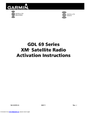
Garmin GDL 69 Instructions Manual (44 pages)
XM Satellite Radio Activation Instructions
Brand:
Garmin
| Category:
Receiver
| Size: 3.95 MB
Table of Contents
Table of Contents
5
1 Overview
7
Introduction
7
Gather Information
7
Table 1-1. Documents
7
2 MX20 - GDL 69 Series Activation
8
Activation Steps
8
Figure 2-1. Data Radio ID and Audio Radio ID Locations
9
Figure 2-2. MX20 with Full Channel List
9
Refreshing
10
Figure 2-3. Activation Refresh Page
10
Table 2-1. MX20 Weather Products Available in United States
10
Deactivating and Reactivating the GDL 69 Series
11
Figure 2-4. Activation Request Sent Message
11
Figure 2-5. Webpage Failure Message
11
3 G1000/G900X/G950 - GDL 69 Series Activation
13
Figure 3-1. AUX - TRIP PLANNING Page
13
Verify the Radios Are Ready to be Activated
14
Figure 3-2. AUX-XM Information Page
14
Figure 3-3. AUX - XM Radio Page
14
Activating the Radio
15
Verifying Subscribed Services
15
Figure 3-4. Lock Activation Screen
15
Figure 3-5. Channel Listings Screen
16
Table 3-1. G1000/G900X/G950 Weather Products Available in United States
16
Refreshing
17
Deactivating and Reactivating the GDL 69 Series
17
Table 3-2. G1000/G900X/G950 Weather Products Available in Canada
17
4 GNS 430/530 - GDL69/69H Activation
19
Activation Steps
19
Verify Signal Reception
19
Figure 4-1. Data Link Menu Page
19
Verify Siriusxm Subscribed Services
20
Figure 4-2. Data Link Status Page
20
Table 4-1. Data Link Status
20
Figure 4-3. Weather Page
21
Figure 4-4. Graphical METAR Page
21
Verify Graphical METAR
21
Verify NEXRAD
21
Figure 4-5. Textual METAR Page
22
Figure 4-6. Wind Data Page
22
Verify Textual METAR
22
Verify Wind
22
Verify Temperature/Dewpoints
23
Refreshing
23
Deactivating and Reactivating the GDL 69 Series
23
Figure 4-7. Temperature/Dewpoints Page
23
5 GNS 430W/530W - GDL 69 Series Activation
25
Activation Steps
25
Verify Signal Reception
25
Figure 5-1. XM Information Page
25
Figure 5-2. XM Information Page Menu
26
Verify Textual METAR
27
Refreshing
27
Figure 5-3. Textual METAR Page
27
Table 5-1. GNS 430W/530W Weather Products Available in United States
27
Deactivating and Reactivating the GDL 69 Series
28
6 GMX 200 - GDL 69 Series Activation
29
Activation Steps
29
Figure 6-1. Data Radio ID and Audio Radio ID Locations
30
Figure 6-2. GMX 200 with Full Channel List
30
Table 6-1. GMX 200 Weather Products Available in United States
30
Refreshing
31
Deactivating and Reactivating the GDL 69 Series
31
7 G500/G600 - GDL 69 Series Activation
33
Figure 7-1. XM Information Page
33
Verify the Radios Are Ready to be Activated
34
Figure 7-2. AUX - XM Radio Page
34
Table 7-1. G500/G600 Weather Products Available in United States
34
Activating the Radio
35
Verifying Subscribed Services
35
Figure 7-3. Lock Activation Screen
35
Refreshing
36
Deactivating and Reactivating the GDL 69 Series
36
Figure 7-4. Channel Listings Screen
36
8 GTN 625/635/650 and GTN 725/750 - GDL 69 Series Activation
37
Figure 8-1. GDL 69 Series Unit Data and Audio Radio Ids on Status Page
37
Figure 8-2. Accessing GDL 69 Series Unit Status Screen Using 'Music' Key
38
Figure 8-3. Accessing GDL 69 Series Unit Status Screen Using 'System' Key
38
Activating the Radio
39
Figure 8-4. Lock Activation Page
39
Verify the Radios Are Ready to be Activated
39
Figure 8-5. Channel Listing Screen
40
Refreshing
40
Verifying Subscribed Services
40
Deactivating and Reactivating the GDL 69 Series
41
Table 8-1. GTN 625/635/650 and GTN 725/750 Weather Products Available in United States
41
Garmin GDL 69 Activation Instructions (38 pages)
XM Satellite Radio
Brand:
Garmin
| Category:
Radio
| Size: 0.91 MB
Table of Contents
Table of Contents
4
1 Overview
7
Introduction
7
Gather Information
7
Table 1-1. Documents
7
2 MX20 - GDL 69/69A Activation
8
Activation Steps
8
Figure 2-1. Data Radio ID and Audio Radio ID Locations
9
Figure 2-2. MX20 with Full Channel List
9
Refreshing
10
Figure 2-3. Activation Refresh Page
10
Table 2-1. MX20 Weather Products Available in United States
10
Deactivating and Reactivating the GDL 69/69A
11
Figure 2-4. Webpage Success Message
11
Figure 2-5. Webpage Failure Message
11
3 G1000 - GDL 69/69A Activation
13
Figure 3-1. AUX - TRIP PLANNING Page
13
Verify the Radios Are Ready to be Activated
14
Figure 3-2. AUX-XM Information Page
14
Figure 3-3. AUX - XM Radio Page
14
Activating the Radio
15
Verifying Subscribed Services
15
Figure 3-4. Lock Activation Screen
15
Figure 3-5. Channel Listings Screen
16
Table 3-1. G1000 Weather Products Available in United States
16
Refreshing
17
Deactivating and Reactivating the GDL 69/69A
17
Table 3-2. G1000 Weather Products Available in Canada
17
4 GNS 430/530 - GDL69 Activation
19
Activation Steps
19
Verify Signal Reception
19
Figure 4-1. Data Link Menu Page
19
Verify XM Subscribed Services
20
Figure 4-2. Data Link Status Page
20
Table 4-1. Data Link Status
20
Figure 4-3. Weather Page
21
Figure 4-4. Graphical METAR Page
21
Verify Graphical METAR
21
Verify NEXRAD
21
Figure 4-5. Textual METAR Page
22
Figure 4-6. Wind Data Page
22
Verify Textual METAR
22
Verify Wind
22
Verify Temperature/Dewpoints
23
Refreshing
23
Deactivating and Reactivating the GDL 69/69A
23
Figure 4-7. Temperature/Dewpoints Page
23
5 GNS 430W/530W - GDL69/GDL69A Activation
25
Activation Steps
25
Verify Signal Reception
25
Figure 5-1. XM Information Page
25
Figure 5-2. XM Information Page Menu
26
Table 5-1. GNS 430W/530W Weather Products Available in United States
26
Verify Textual METAR
27
Refreshing
27
Deactivating and Reactivating the GDL 69/69A
27
Figure 5-3. Textual METAR Page
27
6 GMX 200 - GDL 69/69A Activation
29
Activation Steps
29
Figure 6-1. Data Radio ID and Audio Radio ID Locations
30
Figure 6-2. GMX 200 with Full Channel List
30
Table 6-1. GMX 200 Weather Products Available in United States
30
Refreshing
31
Deactivating and Reactivating the GDL 69/69A
31
7 G600 - GDL 69/69A Activation
33
Figure 7-1. XM Information Page
33
Verify the Radios Are Ready to be Activated
34
Figure 7-2. AUX - XM Radio Page
34
Table 7-1. G600 Weather Products Available in United States
34
Activating the Radio
35
Verifying Subscribed Services
35
Figure 7-3. Lock Activation Screen
35
Figure 7-4. Channel Listings Screen
35
Refreshing
36
Deactivating and Reactivating the GDL 69/69A
36
Garmin GDL 69 Activation Instructions (16 pages)
XM Activation Procedures
Brand:
Garmin
| Category:
Radio
| Size: 0.47 MB
Table of Contents
Table of Contents
3
1 Overview
5
Introduction
5
Gather Information
5
2 MX20 - GDL 69/69A Activation
5
Activation Steps
5
Accessing the MX20 Activation Page
6
Figure 2-1. Data Radio ID and Audio Radio ID Locations
6
Figure 2-2. MX20 with Full Channel List
6
Refreshing
7
Figure 2-3. Activation Refresh Page
7
Figure 2-4. Webpage Success Message
7
Figure 2-5. Webpage Failure Message
7
Test the GDL69/69A with the MX20
8
3 G1000 - GDL 69/69A Activation
8
Figure 3-1. AUX - TRIP PLANNING Page
8
Verify the Radios Are Ready to be Activated
9
Activating the Radio
9
Figure 3-2. XM Information Page
9
Figure 3-3. AUX - XM Radio Page
9
Verifying Subscribed Services
10
Refreshing
10
Figure 3-4. Lock Activation Screen
10
Figure 3-5. Channel Listings Screen
10
4 GNS 430/530 - GDL69 Activation
11
Activation Steps
11
Verify Signal Reception
11
Figure 4-1. Data Link Menu Page
11
Figure 4-2. Data Link Status Page
11
Verify XM Subscribed Services
12
Verify NEXRAD
12
Verify Graphical METAR
12
Figure 4-3. Weather Page
12
Table 4-1. Data Link Status
12
Verify Textual METAR
13
Figure 4-4. Graphical METAR Page
13
Figure 4-5. Textual METAR Page
13
Verify Wind
14
Verify Temperature/Dewpoints
14
Refreshing
14
Figure 4-6. Wind Data Page
14
Figure 4-7. Temperature/Dewpoints Page
14
Garmin GDL 69 Instructions Manual (8 pages)
XM Satellite Radio Instructions for Continued Airworthiness
Brand:
Garmin
| Category:
Radio
| Size: 0.13 MB
Table of Contents
Table of Contents
2
1 Introduction
3
Purpose
3
Scope
3
Document Control
3
Airworthiness Limitations Section
3
Permission to Use Certain Documents
3
Definitions
3
Introduction
4
Description of Alteration
4
Control, Operating Information
4
Servicing Information
5
Periodic Maintenance Instructions
6
Troubleshooting Information
7
Removal and Replacement Information
7
Diagrams
7
Special Inspection Requirements
7
Application of Protective Treatments
7
Data Relative to Structural Fasteners
7
Special Tools
8
Additional Instructions
8
Overhaul Period
8
ICA Revision and Distribution
8
Assistance
8
Implementation and Record Keeping
8
Garmin GDL 69 Manual (15 pages)
Brand:
Garmin
| Category:
Receiver
| Size: 3.27 MB
Table of Contents
Interfaced Equipment
4
Software Version
4
Audio Entertainment Installation Limitations
5
XM Satellite Radio
6
Interface Summary
6
Technical Specifications
7
Reference Documents
12
TSO/ETSO Compliance
12
Fcc Compliance Information
12
FCC Grant of Equipment Authorization
13
Unpacking Unit
13
Warranty Statement
14
Advertisement
Related Products
Garmin XM GDL 69
Garmin GDL 69 Series
Garmin GDL 69/69A
Garmin GDL 69A
Garmin GDL 69H
Garmin GDL 69AH
Garmin GDL 69A SXM
Garmin GDL 30/30A
Garmin GDL 88D
Garmin GDL 50
Garmin Categories
GPS
Watch
Car Navigation system
Avionics Display
Marine GPS System
More Garmin Manuals
Login
Sign In
OR
Sign in with Facebook
Sign in with Google
Upload manual
Upload from disk
Upload from URL