Table of Contents
Advertisement
Quick Links
Advertisement
Table of Contents

Related Manuals for Humminbird 1157c Combo


Summary of Contents for Humminbird 1157c Combo
-
Page 3: Thank You
Humminbird® is designed for trouble-free use in even the harshest marine environment. In the unlikely event that your Humminbird® does require repairs, we offer an exclusive Service Policy - free of charge during the first year after purchase, and available at a reasonable rate after the one-year period. For complete details, see the Warranty section in this manual. -
Page 4: Table Of Contents
Connecting the Control Head Power Cable to the Boat ... 16 Transducer Installation Overview 1197c SI Transducer Installation (1197c SI Combo models only) ... 18 1157c Transducer Installation (1157c Combo models only) ... 25 Trolling Motor Transducer Installation ... 40 Trolling Motor Transducer Options... 40 GPS Receiver Installation Stem Mounting with an Existing 1"... - Page 5 Table of Contents Understanding Side Imaging What’s on the Side Imaging Display ... 54 Side Imaging Technology: How It Works... 56 Side Imaging: On the Water Interpretation... 57 Key Functions POWER/LIGHT Key ... 61 VIEW Key... 61 MENU Key... 62 4-WAY Cursor Control Key ...
- Page 6 Table of Contents Navigate to a Waypoint or Position ... 97 Add a Waypoint Target or Trolling Grid ... 98 Save, Edit or Delete a Route ... 100 Save or Clear a Current Track... 100 Edit, Delete or Hide Saved Tracks ... 101 Man Overboard (MOB) Navigation ...
- Page 7 Table of Contents Navigation X-Press™ Menu Active Side ... 121 Split Position ... 121 Waypoint [Name] (only with an active cursor on a waypoint) ... 121 Cursor to Waypoint (Chart or Combo view only)... 122 Save Current Track ... 122 Clear Current Track ...
- Page 8 Table of Contents Noise Filter (Advanced) ... 136 Max Depth (Advanced) ... 137 Water Type (Advanced) ... 137 Transducer Select ... 138 Color Bar ... 138 Temperature Graph (Sonar View only, with Temperature input) ... 138 Navigation Menu Tab Current Track... 140 Saved Tracks ...
- Page 9 Table of Contents Alarms Menu Tab Alarm Volume ... 153 Depth Alarm ... 153 Fish ID Alarm... 153 Low Battery Alarm ... 154 Aux. Temp. Alarm (with optional-purchase temp. probe or Temp/Speed only) ... 154 Temp. Alarm ... 154 Off Course Alarm ... 155 Arrival Alarm ...
- Page 10 NOTE: Entries in this Table of Contents which list (with Speed Input) or (with Temperature Input) may require the purchase of separate accessories. You can visit our web site at www.humminbird.com to order these accessories online or contact our Customer Resource Center at 1-800-633-1468.
-
Page 11: 1100 Series™ Introduction
Your 1100 Series™ Ultra Wide Screen Fishing System comes in several different configurations. See the following list of products, all of which are covered by this manual, to find your 1100 Series™ configuration: • Humminbird® 1157c/1157c NVB DualBeam Combo: Ultra Wide Screen Fishing System with Chartplotter (Maps) and Dual Frequency Transducer, GPS Receiver included •... -
Page 12: Universal Sonar
When all the echoes are viewed side by side, an easy to interpret "graph" of the bottom, fish and structure appears. The sound pulses are transmitted at various frequencies depending on the application. Very high frequencies (455 kHz) are used for greatest definition but the operating depth is limited. -
Page 13: High Definition Side Imaging Sonar (1197C Si Combo Models Only)
High Definition Side Imaging Sonar (1197c SI Combo models only) Your 1100 Series™ 1197c SI Combo uses Side Imaging sonar to provide a wide yet precise survey of a large area of water, including detailed bottom topography and fish-attracting structure orientation. The Side Imaging transducer returns are processed into an image similar to an aerial photograph. -
Page 14: Quadrabeam Plus™ Sonar (Optional-Purchase Quadrabeam Plus™ Transducer Only)
35° 60° 20° 455 kHz 200 kHz 83 kHz 90° Total Coverage Bottom Coverage = 2 x Depth For a detailed view below the boat, QuadraBeam PLUS™ uses DualBeam PLUS™ technology, with precision 20° and wide 60° beams. QuadraBeam PLUS™ finds more fish faster, and can even tell you where to put your bait by showing if fish are to the left, right or directly beneath your boat. -
Page 15: Mmc/Sd Slot
The GPS Receiver included with your 1100 Series™ Fishing system allows you to combine easy-to-use fishing system and navigation capabilities. The following GPS functionality is currently supported by the 1100 Series™ Fishing system when it is connected to the included GPS receiver: •... -
Page 16: Software Updates
Accessory Bus NOTE: Accessories such as the CannonLink™ Downrigger Controller, InterLink™, and WeatherSense® require separate purchases. You can visit our web site at www.humminbird.com or contact our Customer Resource Center at 1-800-633-1468 for additional details. Video and GPS Output Connectors Your unit has a built-in Video Out connector and a GPS Out connector, which can be used with optional- purchase accessories. -
Page 17: Installation Overview
Installation Overview Please read all instructions that are relevant for your configuration before beginning the installation process. NOTE: Installation procedures will depend on product configuration. The 1100 Series™ has a wide variety of configurations. Power Temp/Speed Temperature Speed through water Optional “Y”... - Page 18 • Installing the GPS Receiver • Testing the complete installation. NOTE: Accessories may require a separate purchase. You can visit our web site at www.humminbird.com to order these accessories online or contact our Customer Resource Center at 1-800-633-1468. 1100 Series™ Connectors...
-
Page 19: Control Head Installation
In- dash mounting. Gimbal Mounting the Control Head If you are gimbal mounting the Humminbird® 1100 Series™, you can pre-assemble the unit in order to plan the best mounting location. Washer... - Page 20 Do not cut any cabling (except the power cable). If your cables are too short, extensions are available from your local dealer or online from www.humminbird.com. 3. After the mounting location has been determined, loosen the gimbal knobs and remove the control head from the gimbal bracket.
- Page 21 6b. If the cables cannot be routed directly beneath the mounting bracket, mark and drill a 1" (25 mm) hole that will allow you to run the cables close to the bracket. Pass the cables through the 1" (25 mm) hole, routing the cables through the grommet and pressing the grommet into place. Place the hole cover over the mounting surface hole, then use it to mark the position of the two mounting screws.
- Page 22 Gimbal Mounting Bracket Grommet Hole Cover 9. Thread the cables through the opening in the back of the cable collector cover. 10. Insert cable connectors into the proper recesses on the cable collector insert. The cable connectors are keyed to prevent reverse installation, so be careful not to force the connectors into the wrong slots.
- Page 23 Plugging the Assembled Cable Connector into the Back of the Control Head NOTE: You may wish to dress the cabling with nylon wire ties in order to hold the cables together and create a cleaner assembly. The Humminbird® 1100 Series™ control head is now ready for operation. Assembling the Cable Collector...
-
Page 24: In-Dash Mounting The Control Head
Make sure that the surfaces you have chosen provide adequate protection from wave shock, and that all cables can reach the control head. NOTE: If a cable is too short for your application, extension cables are available. Call Humminbird® Customer Support at 1-800-633-1468 for more information. - Page 25 7. Insert cable connectors into the proper recesses on the cable collector insert. The cable connectors are keyed to prevent reverse installation, so be careful not to force the connectors into the wrong slots. If you don’t have a cable for every hole in the insert, install the blank plugs to protect the control head from the weather.
-
Page 26: Connecting The Control Head Power Cable To The Boat
NOTE: You may wish to dress the cabling with nylon wire ties in order to hold the cables together and create a cleaner assembly. NOTE: It is very important that the cable collector is used and secured in place in the In-Dash installation. The Humminbird® 1100 Series™ control head is now ready for operation. - Page 27 NOTE: Make sure that the power cable is disconnected from the control head at the beginning of this procedure. NOTE: Humminbird® is not responsible for over-voltage or over-current failures. The control head must have adequate protection through the proper selection and installation of a 3 Amp fuse.
-
Page 28: Transducer Installation Overview
Transducer Installation Overview The 1157c Combo units and the 1197c SI Combo units use two different types of transducers. Find the installation section that describes your transducer type. 1197c SI Transducer Installation (1197c SI Combo models only) If you have a 1197c SI Combo unit, there are two different installation methods for your transducer: •... -
Page 29: Transom Transducer Installation
Transom Transducer Installation (1197c SI Combo models only) If you will be installing a transom mounted transducer, use the procedures in this section. There are two pieces to the transducer mount assembly: the pivot, and the bracket. Your transducer comes with a two- piece metal and plastic bracket assembly. - Page 30 • The best way to locate turbulence-free water is to view the transom while the boat is moving. This method is recommended if maximum high-speed operation is a high priority. If this is not possible, select a location on the transom where the hull forward of this location is smooth, flat and free of protrusions or ribs.
- Page 31 Attaching the Bracket To attach the pivot to the transducer: 1. Attach the pivot to the transducer body, using the two 1/4"-20 x 5/8" (16 mm) machine screws, toothed washers, and square nuts. The toothed washers must fit on the inside of the transducer knuckle, between the pivot and the knuckle.
- Page 32 NOTE: The running position of the transducer is now completely adjustable. Subsequent adjustment may be necessary to tweak the installation after high speed testing. To adjust the running position of the transducer: The transducer mounting bracket allows height and tilt adjustment, while the pivot bolt allows angular adjustment.
- Page 33 VHF radio antenna cables or tachometer cables to reduce the possibility of interference. If the cable is too short, extension cables are available to extend the transducer cable up to a total of 50' (15 m). For assistance, contact the Customer Resource Center at www.humminbird.com or call 1-800-633-1468 for more information.
-
Page 34: Test And Finish The Transducer Installation
Test and Finish the Transducer Installation When you have installed both the control head, the transducer, and accessories and have routed all the cables, you must perform a final test before locking the transducer in place. Testing should be performed with the boat in the water, although you can initially confirm basic operation with the boat out of the water. -
Page 35: 1157C Transducer Installation (1157C Combo Models Only)
1157c Transducer Installation (1157c Combo models only) If you have a 1157c Combo model, there are three different installation methods for your transducer: • Transom Transducer • Inside the Hull Transducer • Trolling Motor Transducer. Your 1100 Series™ uses a Two Piece Kick-up transducer mounting bracket. Find the section that describes the method of installation you will be using. - Page 36 1. Locating the transducer mounting location NOTE: If transom mounting is not possible because of a stepped hull or cavitation noise, and you have a single layer fiberglass hull, In-hull installation is an option. See Inside the Hull Transducer Installation for more information.
- Page 37 NOTE: If you cannot find a transom mount location that will work for your high-speed application, find an In-Hull Transducer by contacting our Customer Resource Center at either 1-800-633-1468 or by visiting our web site at www.humminbird.com. 2. Preparing the Mounting Location In this procedure, you will determine the mounting location and drill two mounting holes, using the transducer mounting bracket as a guide.
- Page 38 NOTE: If you have a flat-bottomed aluminum boat, some additional adjustment may be needed to accommodate the rivets on the bottom of the boat (i.e. the gap may need to be a little smaller than 1/8"). This will help you to avoid excessive turbulence at high speeds. NOTE: If your propeller moves clockwise (in forward, as you're facing the stern of the boat from behind), mount the transducer on the starboard side, and align the bottom right corner of the mounting bracket with the bottom of the boat.
- Page 39 Measuring the Transom Angle Plumb line 12” Transom Angle in degrees (°) Measured Weight Distance (X) Transducer Knuckle Positions Ratchets Placed in Position 2 NOTE: It is important to take your measurement in the figure showing Measuring the Transom Angle, from exactly 12 inches down from the top of the transom.
- Page 40 Inserting the Pivot Bolt 3. Put the pivot bolt through the assembly to hold it in position and loosely install the nut, but do NOT tighten the nut at this time. Insert the pivot arm assembly into the mounting bracket. Do NOT snap the assembly closed, as you will need to access the mounting bracket in the next step.
- Page 41 Adjusting the Initial Transducer Angle 7. Adjust the transducer assembly vertically, until the seam on the leading edge of the transducer (the edge closest to the transom of the boat) is level and just slightly below the hull. Adjusting the Transducer Mounting Position Seam aligned with boat hull NOTE: The transducer has a natural downward slant of 4-5 degrees from leading edge (closest to the boat transom) to trailing edge (farthest away from the boat).
- Page 42 VHF radio antenna cables or tachometer cables to reduce the possibility of interference. If the cable is too short, extension cables are available to extend the transducer cable up to a total of 50'. For assistance, contact the Customer Resource Center at www.humminbird.com or call 1-800-633-1468 for more information.
- Page 43 1. Press POWER once to turn the control head on. If the unit does not power up, make sure that the connector holder is fully seated in the receptacle and that power is available. 2. If all connections are correct and power is available, the Humminbird® control head will enter Normal operation.
- Page 44 6. Once you have reached a consistently good sonar signal at the desired speeds, you are ready to lock down the transducer settings. Force the pivot to the Up position to gain access to the mounting screws, then re-align the mounting bracket against the transom of the boat to match the traced silhouette.
- Page 45 Locking Down the Transducer (Optional) NOTE: You have the option to lock down the Two Piece Kick Up bracket if you do not want the transducer to kick up. Please be aware, however, that the transducer can be damaged if it is locked down and it strikes debris in the water.
-
Page 46: Inside The Hull Transducer Installation
(1157c Combo models only) NOTE: Do NOT install the 1197c Side Imaging transducer inside the hull, as the side looking beams CANNOT penetrate the hull. Only the 1157c Dual Beam PLUS™ transducer can be mounted inside the hull. If you choose to mount your transducer inside the hull of your boat, perform the procedures in this section. - Page 47 Areas of Possible Turbulence Rivets Transom • As a general rule, the faster the boat can travel, the further aft and closer to the centerline of the hull the transducer has to be located in order to remain in contact with the water at high speeds. 2.
- Page 48 4. Fill the hull with enough water to submerge the transducer body. Use a sand-filled bag or other heavy object to hold the transducer in position. The transducer cannot transmit through air, and the water purges any air from between the transducer and the hull, and fills any voids in the coarse fiberglass surface.
- Page 49 5. Coat the face of the transducer and the inside of the hull with epoxy. 6. Press the transducer into place with a slight twisting motion to purge any trapped air from underneath, keeping the end of the transducer that has the mounting knuckle pointed forward, towards the bow of the boat.
-
Page 50: Trolling Motor Transducer Installation
There are also several transducer switches available that support the following configurations: • Two control heads with one transducer • Two transducers with one control head. NOTE: Call the Humminbird® Customer Resource Center at 1-800-633-1468 for details and pricing, or visit www.humminbird.com for more information. GPS Receiver Installation To optimize performance of the GPS receiver, mount it in an area that has full exposure to the sky. -
Page 51: Stem Mounting With An Existing 1" - 14 Thread Stem
GPS receiver, follow the instructions included with that hardware to mount the stem (antenna pole). NOTE: AS-EC10 10' extension cables are available from Humminbird® if your planned routing exceeds 20', (6 m). Maximum cable length, including extensions, should not exceed 50' (16 m). -
Page 52: Access Under Mounting Location
Access Under Mounting Location Follow these steps to deck mount the GPS receiver when routing the cable down through the mounting location: 1. Determine the best location, then test route the 20' (6 m) cable from the mounting location to the control head. -
Page 53: No Access Under Mounting Location
1. Determine the best location, then test route the cable from the mounting location to the control head. NOTE: AS-EC10 10' extension cables are available from Humminbird® if your planned routing exceeds 20', (6 m). Maximum cable length, including extensions, should not exceed 50' (16 m). -
Page 54: Finish Routing The Cable And Check Gps Receiver Operation
Finish Routing the Cable and Check GPS Receiver Operation After installing a GPS receiver, you should perform the following procedure to finish routing the GPS cable to the control head and to check to make sure that the control head is working correctly. 1. -
Page 55: Testing The System Installation
Testing the System Installation After you have completed the installation of the control head and any other accessories such as the GPS receiver, and have made all the cabling connections required, you must test the installation before using the system. To test the installation: 1. -
Page 56: Getting Started - Using Your 1100 Series
Getting Started - Using Your 1100 Series™ Your 1100 Series™ user interface is easy to use. A combination of keys, different views, and situation- specific, customizable menus allows you to control what you see on the color display. Refer to the following illustration, and see Key Functions, Views, and The Menu System for more information. -
Page 57: Powering Up The Control Head
Powering Up the Control Head Turn on your Fishing System by pressing the POWER/LIGHT key. The Title screen is displayed until the Fishing System begins operation. Your 1100 Series™ will begin Normal or Simulator operation, depending on the presence or absence of a transducer. 1100 Series™... -
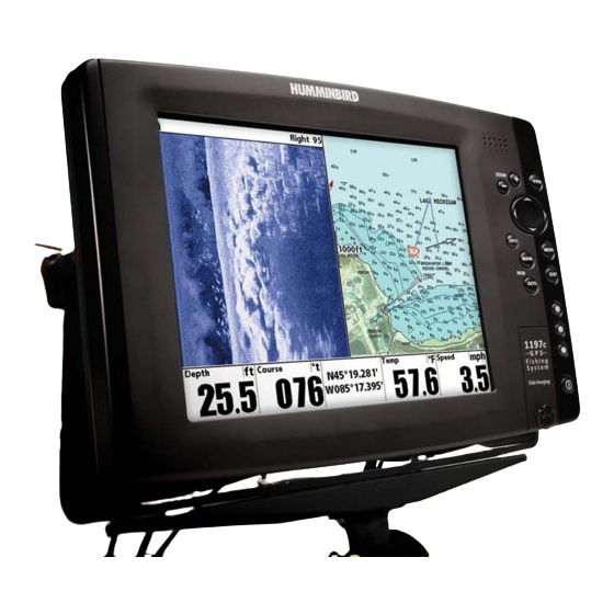
Page 58: What's On The Sonar Display
What’s On the Sonar Display The 1100 Series™ can display a variety of useful information about the area under and adjacent to your Depth - water depth; can be set to alarm when the water becomes too shallow. Temperature - water surface temperature Speed - if a Speed accessory or GPS Receiver is attached, the 1100 Series™... - Page 59 boat, including the following items:...
-
Page 60: Understanding Sonar History
Understanding Sonar History It is important to understand the significance of the 1100 Series™ display. The display does NOT show a literal 3-dimensional representation of what is under the water. Each vertical band of data received by the control head and plotted on the display represents something that was detected by a sonar return at a particular time. -
Page 61: Sonar Bottom Presentation
Sonar Bottom Presentation As the boat moves, the unit charts the changes in depth on the display to create a profile of the Bottom Contour. The type of bottom can be determined from the return charted on the display. A Hard Bottom such as compacted sediment or flat rock appears as a thinner line across the display. - Page 62 WhiteLine® highlights the strongest sonar returns in white, resulting in a distinctive outline. This has the benefit of clearly defining the bottom on the display.
-
Page 63: Understanding Side Imaging
360 feet, with a depth limitation of 100 to 150 feet, depending on the contour of the bottom and when the side beam frequency selection is set for 455 kHz. Please see the Side Imaging Sonar Tutorial at www.humminbird.com for a more detailed explanation. Your Side Imaging transducer also provides traditional sonar imaging at 200/83 kHz. -
Page 64: What's On The Side Imaging Display
What’s on the Side Imaging Display (1197c SI Combo models only) Side Imaging displays a number of easily recognizable features that allow for accurate interpretation of sonar return. For example, rock and gravel provide a clearer sonar return than mud and sand because of that face away from the transducer. - Page 65 bottom contour and structure. For Side Imaging, the bottom composition determines the intensity of the their relative density. Upward slopes that face the transducer reflect sonar better than downward slopes Imaging display that allow for accurate interpretation of bottom contour and structure, including the...
-
Page 66: Side Imaging Technology: How It Works
Side Imaging Technology: How It Works (1197c SI Combo models only) Side Imaging sonar uses two very precise sonar beams that are directed to either side of the boat and “illuminate” the bottom contour, structure, and fish, and display results in a “picture-like” image. •... -
Page 67: Side Imaging: On The Water Interpretation
Side Imaging: On the Water Interpretation (1197c SI Combo models only) Use the following side imaging examples to help you interpret the side imaging display. Imaging Tips Boat speed: Side imaging is best performed at boat speeds between 2 to 6 mph. If the boat is stationary, the same information is displayed over and over. - Page 68 Submerged Ravine with Timber Submerged Timber Submerged Tree Submerged Bridge, Alternative Perspective Submerged Bridge Submerged Ravine Possible Drop Off...
- Page 69 Submerged Standing and Fallen Timber, Plus Bait Fish Bait Fish Submerged Swimming Pool Swimming Pool Standing and Fallen Timber...
- Page 70 Submerged Barge with Dumped Logs Dumped Logs Submerged Barge...
-
Page 71: Key Functions
Key Functions Your 1100 Series™ user interface consists of a set of easy-to-use keys that work with various on-screen views and menus to give you flexibility and control over your fishing experience. Your control head has the following keys: • POWER/LIGHT key •... -
Page 72: Menu Key
MENU Key The MENU key is used to access the menu system. Start-Up Options Menu - Press the MENU key during the power up sequence to view the Start-Up Options menu. X-Press™ Menu - Press the MENU key once for the X-Press™ Menu. The X-Press™ Menu allows you to access frequently-used settings without having to navigate through the whole menu system. -
Page 73: View Preset Keys
VIEW PRESET Keys The VIEW PRESET keys are used to program your three favorite views for quick retrieval. Instead of using the VIEW key to cycle through every view to find the one you want, you can program the VIEW PRESET keys to display a specific view immediately. To program each VIEW PRESET key, use the VIEW key to cycle to the view you want to store. -
Page 74: Mark Key
MARK Key Press the MARK key while in any view to mark the position of a waypoint, either at the current boat location, or, if the Cursor is active, at the current Cursor location. The MARK key only functions if you have the GPS receiver connected, or if you have enabled Screen Snapshot from the Accessories menu tab. -
Page 75: Views
Views The views available on your 1100 Series™ are: Chart/Side Combo View (1197 SI Combo only) Chart/Sonar Combo View Chart/Chart Combo View Chart/Bird’s Eye Combo View • Side Imaging View (1197c SI Combo models only) • Sonar View • Sonar Zoom View •... -
Page 76: Side Imaging View (1197C Si Combo Models Only)
Side Imaging View Side Imaging View shows a shadowed right- and left-looking view from the boat as the boat passes over the bottom. See Side Imaging: On the Water Interpretation for more information about interpreting the Side Imaging view. In this view, you can change which side you look at, the sensitivity of the sonar to allow you to see more or less detail, the range of the side beams, the scrolling speed of the chart, and the color scheme of the display, all from the Side Imaging X-Press™... - Page 77 Cursor Info Box Depth of Cursor Depth Below Cursor Distance to Cursor Bearing to Cursor Active Cursor Icon Freeze Frame - Pressing any arrow on the 4-WAY Cursor Control key will freeze the screen in the Side Imaging View and a cursor and cursor dialog box will be displayed on the screen. The cursor can be positioned on the display using the 4-WAY Cursor Control key to determine the depth of any sonar return.
- Page 78 Side Imaging View, with Active Cursor and Zoom Cursor Info Box Depth of Cursor Depth Below Cursor Distance to Cursor Bearing to Cursor Zoom Level Zoom Preview Box Zoomed View Depth Temp: water surface temperature Speed: speed of boat Course: the current direction the boat is traveling measured in degrees from North VLT: Voltage Full Range View...
-
Page 79: Sonar View
Sonar View Sonar View presents a historical log of sonar returns. The most recent sonar returns are charted on the right side of the window; as new information is received, the older information is moved across the display to the left. A scale with Upper and Lower Depth Range readouts appears along the right edge of the Sonar View. - Page 80 NOTE: If the Depth number is flashing, it means that the unit is having trouble locating the bottom. This usually happens if the water is too deep, the transducer is out of the water, the boat is moving too fast, or for any other reason that the unit can’t accurately receive continuous data.
-
Page 81: Sonar Zoom View
Sonar Zoom View Sonar Zoom View increases the displayed resolution to separate sonar returns that are very close together, such as those caused by fish suspended close to the bottom or within structure. In Zoom View, the display is split to show a narrow slice of the full range view on the right and the zoomed view on the left. The full range view on the right also contains the Zoom Preview Box that shows what part of the full range view is shown in zoom view on the left;... -
Page 82: Split Sonar View
Split Sonar View Split Sonar View displays sonar returns from the 83 kHz wide beam on the left side of the screen and displays sonar returns from the 200 kHz narrow beam on the right side of the screen. You can use the Split Sonar View to make side by side comparisons between the sonar returns from the 83 kHz wide beam and the 200 kHz narrow beam. -
Page 83: Side/Sonar Combo View (1197C Si Combo Models Only)
Side/Sonar Combo View (1197c SI Combo models only) Side/Sonar Combo View shows regular sonar information and side imaging sonar information in a combination split screen. You can perform any of the functions for either of these views, but only when the view you want to control is selected as the active side (see Sonar X-Press™... -
Page 84: Snapshot And Recording View
Snapshot and Recording View Snapshot and Recording View displays and allows you to view both screen snapshot thumbnails and recording icons captured to an optional-purchase MMC/SD card installed in your unit. In addition, when you are in the Snapshot and Recording View, Start Recording, Stop Recording, Delete Image, Delete All Images, Delete Recording, Delete All Recordings, Pings Per Second, Playback Speed and Stop Playback are added to the X-Press™... - Page 85 Highlighted Screen Snapshot Thumbnail Unavailable Icon Recording Icon Information Box Name of Snapshot NOTE: For snapshots and recordings, the indicator bar has several states: during recording, the amount of space remaining on the MMC/SD card is indicated on the status bar. During playback, the amount of time/memory remaining to play is indicated on the status bar.
- Page 86 For more information, see Accessories Menu Tab: Using Screen Snapshot and Snapshot and Recording X-Press™ Menu. When you start a screen snapshot, you will see a message that a waypoint has been created at the point where your cursor is on the screen, and the screen will freeze while the snapshot is being saved to the MMC/SD card.
- Page 87 Recording Indicator Name of recording Time and Date recording started Position when recording started Current Ping Rate Highlighting a recording: You can scroll through the whole list of recording icons available in the Snapshot and Recording View using the 4-WAY Cursor keys. The highlighted icon will be surrounded by arrows, and a green play triangle will appear to its right.
- Page 88 NOTE: Sonar chart speed is increased during Fast Forward and reversed during Rewind. This may reduce the quality of the sonar image, since at higher speeds, not every sonar return can be processed and displayed. NOTE: Navigation is not affected by the Sonar Recording feature, but any active navigation is cancelled when playback begins or ends.
-
Page 89: Side Beam View (With Optional-Purchase Quadrabeam Plus™ Transducer Only)
Side Beam View (with optional-purchase QuadraBeam PLUS™ transducer only) Side Beam View is only available if you have connected a QuadraBeam™ transducer accessory and when Transducer Select is set to QuadraBeam (see Sonar Menu Tab: Transducer Select). This view shows sonar information from both the left and right 455 kHz beams and the 200 kHz down-looking beam in one view. - Page 90 Classic layout: The top portion of the display presents a historical log of sonar returns from the 200 kHz down-looking sonar beam. New information in the down beam panel scrolls from right to left. The bottom portion of the display presents a historical log of sonar returns from the 455 kHz right- and left-looking sonar beams.
- Page 91 Slanted layout: This layout presents the two 455 kHz side sonar beams and the 200 kHz down-looking sonar beam as three panels of historical data. This layout is presented as three slanted panels. New information appears on the right, and scrolls to the left. Depth Temp: water surface temperature Speed: speed of boat...
-
Page 92: Bird's Eye View
Bird's Eye View Bird's Eye View shows a 3D perspective view of the track and the chart land contour from a point above and behind the boat (the eye point). As the boat turns, the eye point moves to follow the boat. When you press the 4-WAY Cursor key in any of the Bird’s Eye Views, the position of the eye point will shift. - Page 93 Next Waypoint Depth XTE (Cross Track Error): Distance of Boat from Route Speed: the measurement of the boat’s progress across a given distance, and is the speed measurement provided by GPS Course: the current direction the boat is traveling measured in degrees from North Bird’s Eye View (Navigating) Bearing: Direction to Destination Waypoint...
-
Page 94: Chart/Bird's Eye Combo View
Chart/Bird’s Eye Combo View Chart/Bird’s Eye Combo View shows both the Chart and Bird’s Eye views in a combination split screen. You can perform any of the functions for either of these views, but only when the view you want to control is selected as the active side (see Navigation X-Press™... - Page 95 Next Waypoint Depth XTE (Cross Track Error): Distance of Boat from Route Speed: the measurement of the boat’s progress across a given distance, and is the speed measurement provided by GPS Course: the current direction the boat is traveling measured in degrees from North Bearing: Direction to Destination Waypoint measured in degrees from North...
-
Page 96: Chart View
Chart View Chart Views - The standard Chart, Chart No Readouts, and Chart/Chart Combo Views, as well as the Chart side of the Chart/Bird's Eye Combo View and the Chart/Bird's Eye Combo Instrument View, all show cartography from the built-in UniMap™ or an optional MMC/SD map for the area surrounding your current position. - Page 97 Chart View (with Cursor) with optional-purchase Navionics® Cartography Cursor Info Box Latitude and Longitude Position of Cursor Distance to Cursor Bearing to Cursor Depth Temp: Water Surface Temperature Speed: Speed of Boat Course: the current direction the boat is traveling measured in degrees from North VLT: Voltage Track Boat Icon...
- Page 98 Chart View (Navigating) with optional-purchase Navionics® Cartography Next Waypoint Depth XTE (Cross Track Error): Distance of Boat from Route Speed: the measurement of the boat’s progress across a given distance, and is the speed measurement provided by GPS Course: the current direction the boat is traveling measured in degrees from North Bearing: Direction to Destination Waypoint measured in degrees from North...
-
Page 99: Chart/Chart Combo View
Chart/Chart Combo View Chart/Chart Combo View shows two versions of the Chart view in a combination split screen, so that you can see the position of the boat on one side while you zoom in or perform other functions on the other. You can perform any of the functions for the Chart view, but only on the side of the view you have selected as the active side (see Navigation X-Press™... - Page 100 Next Waypoint Depth XTE (Cross Track Error): Distance of Boat from Route Speed: the measurement of the boat’s progress across a given distance, and is the speed measurement provided by GPS Course: the current direction the boat is traveling measured in degrees from North Bearing: Direction to Destination Waypoint measured in degrees from North...
-
Page 101: Chart/Sonar Combo View
Chart/Sonar Combo View Chart/Sonar Combo View shows both the Chart and Sonar views in a combination split screen. You can perform any of the functions for either of these views, but only when the view you want to control is selected as the active side (see Sonar X-Press™... -
Page 102: Chart/Side Combo View (1197C Si Combo Models Only)
Chart/Side Combo View (1197c SI Combo models only) Chart/Side Combo View shows regular chart information and side imaging sonar information in a combination split screen. You can perform any of the functions for either of these views, but only when the view you want to control is selected as the active side (see Navigation X-Press™... -
Page 103: Chart Orientation
Chart Orientation All the chart views allow you to choose the orientation of the chart. When North-Up orientation is selected, True North is shown at the top of the display. In other words, objects located to the north of the boat are drawn above the boat. - Page 104 NOTE: Your Chart screen will automatically declutter and simplify as you zoom out. When you zoom out, all waypoint icons that might otherwise overlap each other will declutter the screen by changing into very small blue icons, and individual waypoint names will be hidden. When you're panning, and your cursor snaps to a waypoint that is using the declutter icon, that waypoint will display its full-size icon and name temporarily (until you move the cursor off of it).
-
Page 105: Introduction To Navigation
Introduction to Navigation Use the 1100 Series™ to establish waypoints at areas of interest and to navigate to those waypoints via a saveable route (representing the shortest intended distance between waypoints). You can also view and save tracks, which represent the actual path of the boat. Waypoints, Routes and Tracks Waypoints are stored positions that allow you to mark areas of interest or navigation points. -
Page 106: Save, Edit, Or Delete A Waypoint
Routes link two or more waypoints together to create a path for navigation, and are used in trip planning. You can link individual waypoints together by using the GOTO key. A route represents your intended navigation and shows the shortest path from each waypoint to the next. As you travel a route, staying on the route line is the most efficient way to get to your destination, although you should always look out for obstacles not shown on the chart. -
Page 107: Navigate To A Waypoint Or Position
To make it easier to select a waypoint, select Sort By and press the RIGHT or LEFT Cursor keys to select a sort order: • Name shows the waypoints alphabetically • Time shows the most recently-created waypoint first • Distance shows the closest waypoint first. Delete a waypoint: From the Waypoints submenu, select Delete and press the RIGHT Cursor key to display a list of waypoints. -
Page 108: Add A Waypoint Target Or Trolling Grid
Add a Waypoint Target or Trolling Grid Add or Remove a Waypoint Target: From the Waypoints submenu (accessed from the Navigation main menu), select Target and press the RIGHT Cursor key to display a list of waypoints. Select the waypoint you want to target. - Page 109 Add or Remove a Trolling Grid: From the Waypoints submenu (accessed from the Navigation main menu), select Grid and press the RIGHT Cursor key to display a list of waypoints. Select the waypoint to which you want to add the grid. The trolling grid will appear on all of the navigation views, and can be used as a guide when trolling around a waypoint.
-
Page 110: Save, Edit Or Delete A Route
Save, Edit or Delete a Route Save the current route: While you are navigating, the current route can be saved. From the Navigation X- Press™ Menu, select Save Current Route and press the RIGHT Cursor key. Navigation will continue. Display the Routes submenu: From any view, press the MENU key twice to display the Main Menu System, then use the RIGHT Cursor key to select the Navigation tab. -
Page 111: Edit, Delete Or Hide Saved Tracks
Edit, Delete or Hide Saved Tracks Display the Tracks Submenu: From any view, press the MENU key twice to display the Main Menu System, then use the RIGHT Cursor key to select the Navigation tab. Select Tracks and press the RIGHT Cursor key to display the Tracks submenu. - Page 112 Activate MOB navigation: Press and hold the GOTO key for more than 1.5 seconds to activate the Man Overboard (MOB) function. Cancel MOB navigation: From the Navigation X-Press™ menu, select Cancel MOB and press the RIGHT Cursor key. Canceling MOB navigation removes the route and any waypoints created using the GOTO key, but does not remove any saved routes from memory.
-
Page 113: The Menu System
The Menu System The menu system is divided into easy-to-use menu modules. The main components of the menu system are: Start-Up Options Menu: Press the MENU key during the power up sequence to view the Start-Up Options menu. See Start-Up Options Menu. X-Press™... - Page 114 QUICK TIPS: • When your cursor is within a menu tab, press the EXIT key to jump directly to the top of the tab. • If you are at the bottom of a menu tab, press the DOWN Cursor key to jump directly to the top of the tab.
- Page 115 Setup Tab, Normal User Mode Setup Tab, Advanced User Mode...
-
Page 116: Start-Up Options Menu
Start-Up Options Menu Press the MENU key when the Title screen is displayed to access the Start-Up Options menu. Use the UP or DOWN 4-WAY Cursor keys to position the cursor, then the RIGHT Cursor key to select one of the following choices. If you wait too long, the system will default to whichever menu mode happens to be highlighted: •... -
Page 117: Simulator
Normal operation. NOTE: At startup, while still on the Title screen (while the name of your Humminbird® model is still on the screen) you must press the MENU key and then select Simulator manually to enter Simulator mode. Manually selecting Simulator from the Start-Up Options menu allows you to pre-configure your Fishing System for on the water operation. -
Page 118: Self Test
Self Test Self Test displays results from the internal diagnostic self test, including unit serial number, Printed Circuit Board (PCB) serial number, software revision, total hours of operation and the input voltage. IP and MAC addresses are also displayed. Accessory Test Accessory Test lists the accessories connected to the system. -
Page 119: Gps Diagnostic View
GPS Diagnostic View GPS Diagnostic View, which is only available when a GPS Receiver is attached to your 1100 Series, shows a sky chart and numerical data from the GPS receiver. The sky chart shows the location of each visible GPS satellite with its satellite number and a signal strength bar. -
Page 120: Sonar X-Press™ Menu
Sonar X-Press™ Menu The Sonar X-Press™ Menu provides access to the settings most frequently used. Press the MENU key once while in any of the Sonar Views to access the Sonar X-Press™ Menu. NOTE: Menu choices will vary depending on system settings such as whether the unit is set for Advanced User mode. -
Page 121: Active Side
active; key presses will only affect the active side of the screen. When a menu is displayed, the non-active side of the screen will be grayed out; at any other time, a green arrow will point to the active side. Combo Views usually display sonar on the left, with charts or Bird’s Eye usually on the right. -
Page 122: Sensitivity
the sensitivity shows more sonar returns from small baitfish and suspended debris in the water; however, the display may become too cluttered. When operating in very clear water or greater depths, increased sensitivity shows weaker returns that may be of interest. Decreasing the sensitivity eliminates the clutter from the display that is sometimes present in murky or muddy water. -
Page 123: Upper Range (Advanced: Sonar, Split Sonar And Active Sonar Side Views Only)
Upper Range sets the shallowest depth range that will be displayed on the Sonar, Split Sonar and Active Sonar Side Views. The Upper Range menu choice is available when User Mode is set to Advanced (see Setup Menu Tab: User Mode) and can only be accessed from the Sonar, Split Sonar and Active Sonar Side Views. -
Page 124: Chart Speed
moves across the display, and consequently the amount of detail shown. A faster speed shows more information in the Sonar Views and is preferred by most anglers; however, the sonar information moves across the display quickly. A slower speed keeps the information on the display longer, but the bottom and fish details become compressed and may be difficult to interpret. -
Page 125: Bottom Range (Sonar Zoom View Only, When Bottom Lock Is On)
Bottom Range allows you to control how much of the water column, measured up from the bottom, is shown in the Sonar Zoom View. Choose a small value to see low-lying bottom structure or details of the bottom return. Choose a larger value to see large structure in deeper water. It is possible to set the Bottom Range to be greater than the depth. -
Page 126: Side Imaging X-Press™ Menu (1197C Si Combo Models Only, Side Imaging Views Only)
Side Imaging X-Press™ Menu (1197c SI Combo models only, Side Imaging Views only) The Side Imaging X-Press™ Menu provides access to the settings most frequently-used. Press the MENU key once while in any of the Sonar Views to access the Side Imaging X-Press™ Menu. Side Imaging X-Press™... -
Page 127: Active Side
Active Side allows you to select which side of a Combo View will be active; key presses will only affect the active side of the screen. When a menu is displayed, the non-active side of the screen will be grayed out;... -
Page 128: Si Sensitivity
SI Sensitivity controls how much detail is shown on the display. Increasing the sensitivity shows more sonar returns from small baitfish and suspended debris in the water; however, the display may become too cluttered. When operating in very clear water or greater depths, increased sensitivity shows weaker returns that may be of interest. -
Page 129: Si Colors
SI Colors allows you to select which color palette you would like to use for the display. To change the SI Colors: 1. Highlight SI Colors on the Side Imaging X-Press™menu. 2. Use the LEFT or RIGHT 4-WAY Cursor Control keys to change the color palette. (Inverse, Gray, Brown, Blue, Green, Default = Blue) SI Colors (1197c SI Combo models only) -
Page 130: Navigation X-Press™ Menu
Navigation X-Press™ Menu The Navigation X-Press™ Menu provides access to the settings most frequently used. Press the MENU key once while in the Bird's Eye View, the Chart or the Chart/Sonar Combo, Chart/Chart Combo View, or Chart/Bird’s Eye Combo View to access the Navigation X- Press™... -
Page 131: Active Side
active; key presses will only affect the active side of the screen. When a menu is displayed, the non-active side of the screen will be grayed out; at any other time, a green arrow will point to the active side. Combo Views usually display sonar on the left, with charts or Bird’s Eye usually on the right. -
Page 132: Cursor To Waypoint (Chart Or Combo View Only)
The Waypoint Submenu contains the following menu choices: Edit allows you to edit the Name, Position (Latitude and Longitude) and select the Icon that will be used to represent the waypoint in the Chart and Combo Views. Delete allows you to delete a waypoint from the list of saved waypoints. Target allows you to apply a target to a waypoint selected from the list of waypoints. -
Page 133: Clear Current Track
displayed and start a new track at the present position. To Clear Current Track: 1. Highlight Clear Current Track on the Navigation X-Press™ Menu. 2. Use the RIGHT 4-WAY Cursor Control key to initiate clearing the current track. 3. The Confirm dialog box will appear. To clear the current track, press the RIGHT Cursor key once more. -
Page 134: Cancel Navigation (Only When Navigating)
Cancel Navigation discards the current route and exits Navigation Mode. This menu choice will only appear when you are currently navigating a route. This will not delete a previously-saved route. To Cancel Navigation: 1. Highlight Cancel Navigation on the Navigation X-Press™ Menu. 2. -
Page 135: Remove Grid (Only If A Grid Is Active)
Remove Grid removes the waypoint grid from the display. This menu choice will only appear when a grid has already been applied to a waypoint. To Remove a Grid: 1. Highlight Remove Grid on the Navigation X-Press™ Menu. 2. Use the RIGHT 4-WAY Cursor Control key to remove the grid. Waypoint [Name] allows you to view the waypoints submenu for the most recently created waypoint. -
Page 136: (Snapshot And Recording View Only)
Snapshot and Recording X-Press™ Menu (Snapshot and Recording View only) The Snapshot and Recording X-Press™ menu provides access to the image management and sonar recording functions. Press the MENU key once while in the Snapshot and Recording View to access the Snapshot and Recording X-Press™ menu. NOTE: For more information, see Snapshot and Recording View. -
Page 137: Start Recording (Optional-Purchase Mmc/Sd Card, Snapshot And Recording View Only)
Start Recording allows you to start sonar recording from the Snapshot and Recording View. This menu option is only available when you have an optional-purchase MMC/SD card installed and you are in Snapshot and Recording View. To start sonar recording: 1. -
Page 138: Delete All Images (Optional-Purchase Mmc/Sd Card, Snapshot And Recording View Only)
Delete All Images allows you to delete all the images at once from the Snapshot and Recording View. This menu option is only available when you have an optional-purchase MMC/SD card installed and you are in Snapshot and Recording View. To delete all images: 1. -
Page 139: Pings Per Second (Optional-Purchase Mmc/Sd Card, Snapshot And Recording View Only)
Pings Per Second allows you to specify the maximum ping rate for the sonar recording currently in progress from the Snapshot and Recording View. This menu option is only available when you have an optional-purchase MMC/SD card installed and you are in Snapshot and Recording View and are actively recording (not playing back). -
Page 140: Sonar Menu Tab
Sonar Menu Tab Press the MENU key twice to access the Main Menu System and then press the RIGHT Cursor key to select the Sonar tab. NOTE: Menu choices will vary depending on system settings such as whether the unit is set for Advanced User mode or what transducer is currently selected. -
Page 141: Beam Select
When set to 200/83 kHz, the returns from both beams are blended. The Split Sonar View continues to display the sonar returns from each beam in their respective windows. The blended information is shown in the Sonar View. The RTS® Window in the Sonar View will only show the returns from the 200 kHz narrow beam. When set to 200 kHz, only the returns from the 200 kHz narrow beam will be displayed in the Sonar View. -
Page 142: Fish Id Sensitivity
When Fish ID+™ is turned off, the 1100 Series™ shows only the raw sonar returns on the display. These returns will often result in "arches" forming on the display, indicating potential targets. Due to the transducer beam angle, the distance to a fish decreases as the fish moves into the beam, and then increases as it moves out again, creating a Fish Arch when this distance change is shown on the display. -
Page 143: Real Time Sonar (Rts®) Window
turns it off in the Sonar View. The RTS® Window always updates at the fastest rate possible and only displays returns that are within the transducer beam. (See Getting Started - Using Your 1100 Series™: Real Time Sonar [RTS®] Window for more information.) RTS®... -
Page 144: Bottom View
structure on the display. Structure ID® represents weak returns in blue and strong returns in red. WhiteLine® highlights the strongest sonar returns in white resulting in a distinctive outline. This has the benefit of clearly defining the bottom on the display. See Bottom Presentation for more information. To adjust the Bottom View: 1. -
Page 145: 455 Khz Sensitivity (Advanced, With Optional-Purchase Quadrabeam Plus™ Transducer Only)
User Mode is set to Advanced (see Setup Menu Tab: User Mode). NOTE: The 455 kHz Sensitivity requires the purchase of the QuadraBeam PLUS™ transducer. You can visit our web site at www.humminbird.com to order this accessory online or contact our Customer Resource Center at 1-800-633-1468. -
Page 146: Surface Clutter (Advanced)
Surface Clutter adjusts the filter that removes surface clutter noise caused by algae and aeration. The lower the setting, the less surface clutter will be displayed. The Surface Clutter menu choice is available when User Mode is set to Advanced (see Setup Menu Tab: User Mode). To change the Surface Clutter setting: 1. -
Page 147: Max Depth (Advanced)
Max Depth adjusts the maximum depth of operation. The performance of your 1100 Series™ can be tuned to the maximum depth you will be fishing in by setting the Max Depth. When a maximum depth is set, your 1100 Series™ will not attempt to acquire sonar data below that depth, thus increasing overall performance. -
Page 148: Transducer Select
NOTE: If you have purchased an 1197c, all transducer choices besides the High Definition Sidescan transducer require a separate purchase. NOTE: If you have purchased an 1157c, the QuadraBeam PLUS™, Dual 50/200 kHz and Universal Sonar 2 transducers require a separate purchase. The 1157c does NOT support High-Definition Sidescan, Compact Sidescan or Sidescan transducers. -
Page 149: Navigation Menu Tab
Navigation Menu Tab Press the MENU key twice to access the Main Menu System, then press the RIGHT cursor key to select the Navigation tab. NOTE: Menu choices will vary depending on system settings. Navigation Menu... -
Page 150: Current Track
To view the Current Track Submenu: 1. Highlight Current Track on the Navigation main menu. 2. Use the RIGHT 4-WAY Cursor Control keys to view the Current Track submenu. The Current Track Submenu contains the following menu choices: Save Current Track allows you to save the current track. Clear Current Track allows you to clear the current track. -
Page 151: Waypoints
To view the Waypoints Submenu: 1. Highlight Waypoints on the Navigation main menu. 2. Use the RIGHT 4-WAY Cursor Control keys to view the Waypoints submenu. The Waypoints Submenu contains the following menu choices: Create allows you to create a new waypoint and edit it immediately. The current boat position will be used as the default, but you can set the coordinates to any valid position. -
Page 152: Routes
To view the Routes Submenu: 1. Highlight Routes on the Navigation main menu. 2. Use the RIGHT 4-WAY Cursor Control keys to view the Routes submenu. The Routes Submenu contains the following menu choices: Create allows you to create a new, empty route and add waypoints to it immediately. Edit allows you to select a previously-saved route and edit its name and the waypoints on it. -
Page 153: North Reference
To change the North Reference setting: 1. Highlight North Reference on the Navigation main menu. 2. Use the LEFT or RIGHT 4-WAY Cursor Control keys to change the North Reference setting. (True, Magnetic, Default = True) grid in degrees, where a setting of 0° displays a standard North, South, East, West alignment. See Waypoints for information on how to set a Grid. -
Page 154: Track Min Distance (Advanced)
Track Min Distance allows you to set a minimum distance of travel before a trackpoint is added to the track. NOTE: Track Min Distance works in conjunction with Trackpoint Interval. Both conditions must be met before a trackpoint is added to the current track. To change the Track Minimum Distance setting: 1. -
Page 155: Course Projection Line
extending from the bow of the boat that projects your current course, and shows where the boat will go if you continue on your present course. To change the Course Project Line setting: 1. Highlight Course Projection Line on the Navigation main menu. 2. -
Page 156: Continuous Navigation Mode
fish around a particular waypoint, even if you pass over it multiple times. To activate or de-activate Continuous Navigation: 1. Highlight Continuous Navigation Mode on the Navigation main menu. 2. Use the LEFT or RIGHT 4-WAY Cursor Control keys to turn Continuous Navigation Mode On or Off (Off, On, Default = Off) GPS Receiver Override allows you to set which GPS receiver to use if you have multiple GPS receivers plugged in to your system. -
Page 157: Chart Menu Tab
Chart Menu Tab Press the MENU key twice to access the Main Menu System and then press the RIGHT Cursor key to select the Chart tab. NOTE: Menu choices will vary depending on system settings such as whether the unit is set for Advanced User mode. Chart Menu... -
Page 158: Chart Detail Level
displayed on the Navigation Views. Basic shows land areas, ports, obstructions and restricted areas. Navigation shows navaids, landmarks, ferryways and navigation routes in addition to the Basic information. Underwater shows depth contours, fishing areas, underwater wrecks, tides and currents in addition to the Basic and Navigation information. -
Page 159: Lat/Lon Grid
To change the Lat/Lon Grid setting: 1. Highlight Lat/Lon Grid on the Chart main menu. 2. Use the LEFT or RIGHT 4-WAY Cursor Control keys to change the Lat/Lon Grid setting. (Hidden, Visible, Default = Hidden) NOTE: Spot Soundings are only available with optional-purchase MMC/SD cards. To change the Spot Soundings setting: 1. -
Page 160: Chart Select
in charts or a map card. If you select Auto, your unit will select a chart automatically. To activate or de-activate Chart Select: 1. Highlight Chart Select on the Navigation main menu. 2. Use the LEFT or RIGHT 4-WAY Cursor Control keys to select which chart to use. (Default = Auto) if you have an NVB unit. -
Page 161: Set Map Offset (Advanced)
Set Map Offset allows you to change the map offset used by the 1100 Series™. NOTE: The Map Offset will be applied to all maps and not just the map that requires the correction. The Map Offset should be cleared if a different map is to be used. To change the Map Offset setting: 1. -
Page 162: Alarms Menu Tab
Alarms Menu Tab From any view, press the MENU key twice to access the Main Menu System. The Alarms tab will be the default selection. NOTE: When an alarm is triggered, you can silence it by pressing any key. The alarm will be silenced, and will not be triggered again until a new instance of the alarm condition is detected. -
Page 163: Alarm Volume
To change the Alarm Volume setting: 1. Highlight Alarm Volume on the Alarms main menu. 2. Use the LEFT or RIGHT 4-WAY Cursor Control keys to change the Alarm Volume setting. (Mute, 1 - 10, Default = 5) To change the Depth Alarm setting: 1. -
Page 164: Low Battery Alarm
or less than the menu setting. The battery alarm will only sound for the battery that is connected to the 1100 Series™. The Low Battery Alarm should be set to warn you when the battery voltage drops below the safety margin that you have determined. For instance, if you are running a trolling motor (battery operated), you would want to set the Low Battery Alarm to sound before the battery voltage drops too low for it to be used to start your main, gasoline-powered engine. -
Page 165: Off Course Alarm
based on the menu setting when navigating. Off Course Alarm allows you to set how far the boat is allowed to move off course before the Off Course Alarm will sound. Arrival Alarm Circle To change the Off Course Alarm setting: 1. -
Page 166: Drift Alarm
boat’s anchored position, based on the menu setting. Drift Alarm allows you to set the size of a perimeter around the boat’s anchored position; if the anchored boat drifts outside of that perimeter, the Drift Alarm will sound. Drift Alarm Circle To change the Drift Alarm setting: 1. -
Page 167: Setup Menu Tab
Setup Menu Tab From any view, press the MENU key twice to access the tabbed Main Menu System, then press the RIGHT cursor key until the Setup tab is selected. NOTE: Menu choices will vary depending on system settings such as whether the unit is set for Advanced User mode and what accessories are attached to the control head. -
Page 168: Sound Volume
by the control head (except for the volume of the alarms, which is controlled by Alarm Volume Control). To change the Volume Control setting: 1. Highlight Volume Control on the Setup main menu. 2. Use the LEFT or RIGHT 4-WAY Cursor Control keys to change the Volume Control setting. (Mute, 1 - 10, Default = 5) To change the Units - Depth setting: 1. -
Page 169: Units - Speed (With Speed Input Only)
Units - Speed selects the units of measure for speed-related readouts. To change the Units - Speed setting: 1. Highlight Units - Speed on the Setup menu. 2. Use the LEFT or RIGHT 4-WAY Cursor Control keys to change the Units - Speed setting. (kph [International models only], mph, kts, Default = kph for International models and mph for Domestic models) set to Normal, only the basic menu options are shown. -
Page 170: Restore Defaults
To Restore Defaults: 1. Highlight Restore Defaults on the Setup menu. 2. Use the RIGHT 4-WAY Cursor Control key to initiate restoring defaults. 3. The Confirm dialog box will appear. To reset the defaults, press the RIGHT Cursor key once more. To cancel Restore Defaults, press the LEFT Cursor key. - Page 171 Each readout position can either be empty or contain one of the following: 5 Selectable Readouts; Non-Navigation Mode Aux. Temp The current detected water temperature from an optional-purchase Temperature Probe or Temp/Speed accessory. Course Course is the current direction the boat is traveling measured in degrees from North (i.e. 321°, where 000° is North, 090°...
- Page 172 NOTE: When the readout under the water column is turned off (as shown in the illustrations), the sonar display will expand to fill the screen. To Select Readouts: 1. Make sure you are in Advanced User Mode, then highlight Select Readouts on the Setup main menu.
-
Page 173: Select Nav Readouts (Advanced)
Select Nav Readouts sets the individual digital readouts that will be used only during navigation on all non-instrument views. This feature allows you to select what information will be displayed in each of a variable number of fixed-position readouts arranged at the bottom of the screen on various views, or whether a particular readout will be turned off, displaying nothing in that area. - Page 174 5 Selectable Readouts; Navigation Mode Bearing Bearing is the direction to a destination waypoint measured in degrees from North (i.e. 321°, where 000° is North, 090° East, 180° is South, 270° is West). CMG/SMG Course Made Good/Speed Made Good. Course Made Good is the angle between the starting point on a route and the current position of the boat.
-
Page 175: Depth Offset (Advanced)
Depth Offset will adjust the digital depth readout to indicate depth from the waterline or boats keel. Enter a positive vertical measurement from the transducer to the waterline to read the depth from the waterline. Enter a negative vertical measurement from the transducer to keel to read the depth from the keel. This menu choice is available only when in Advanced User Mode (see Setup Menu Tab: User Mode.) To change the Depth Offset setting: 1. -
Page 176: Speed Calibration (Advanced, With Speed Paddlewheel Only)
Speed Calibration will adjust the speed readout by the percentage entered, and will appear in the menu if a Speed accessory is connected and the paddlewheel has moved at least once, when the unit is in Advanced User Mode (see Setup Menu Tab: User Mode.) To change the Speed Calibration setting: 1. -
Page 177: Position Format (Advanced)
Position Format selects the format of the latitude and longitude position display. This menu choice is available only when in Advanced User Mode (see Setup Menu Tab: User Mode.) To change the Position Format setting: 1. Make sure you are in Advanced User Mode, then highlight Position Format on the Setup menu. -
Page 178: Digits Format (Advanced)
Digits Format allows you to add a tenth decimal place to readouts such as Temperature and Depth. The format can be changed to small format, large format or no format. This menu choice is available only when in Advanced User Mode (see Setup Menu Tab: User Mode.) To change the Digits Format setting: 1. -
Page 179: Sonar
To turn Sonar on or off: 1. Highlight Sonar on the Setup menu. 2. Use the LEFT or RIGHT 4-WAY Cursor Control keys to change the Sonar to On or Off (Off, On, Default = On). To use the Video Out feature: 1. -
Page 180: Views Menu Tab
Views Menu To Change the View Status of Any View: 1. Highlight the View main menu tab. 2. Use the UP or DOWN 4-WAY Cursor Control keys to select a View. 3. Use the LEFT or RIGHT 4-WAY Cursor Control keys to change the status of the view from Hidden to Visible or vice versa. -
Page 181: Accessories Menu Tab
Accessories Menu (no accessories attached) NOTE: The accessory to enable WeatherSense® requires a separate purchases. You can visit our web site at www.humminbird.com or contact our Customer Resource Center at 1-800-633-1468 for additional details. Accessories Menu (with accessories attached) -
Page 182: Using Screen Snapshot
Screen Snapshot is enabled, pressing the MARK key creates a saved screen capture on the optional- purchase MMC/SD card installed in your unit’s card slot. All menus, dialog boxes, warnings and messages are captured and saved automatically. Once you have created a screen capture, a screen capture thumbnail is added to the Snapshot and Recording View, and is available to view at a later date. - Page 183 2. Press the VIEW key until you see the Snapshot and Recording View. 3. You can scroll through the whole list of captures in this view using the 4-WAY Cursor keys. Highlight a thumbnail (using the Up or Down 4-Way Cursor keys), then use the Right 4-Way Cursor key to view the full image.
-
Page 184: Troubleshooting
Troubleshooting Before contacting the Humminbird® Customer Resource Center, please read the following section. Taking the time to review these troubleshooting guidelines may allow you to solve a performance problem yourself, and therefore avoid sending your unit back for repair. 1100 Series™ Doesn’t Power Up If your 1100 Series™... -
Page 185: Display Problems
Display Problems There are several main conditions or sources of possible interference that may cause problems with the quality of the information displayed on the control head. Look in the following table for some symptoms of display problems and possible solutions: Problem The control head loses power at high speeds. -
Page 186: Finding The Cause Of Noise
Finding the Cause of Noise Electrical noise usually affects the display with many black dots at high speeds, and high sensitivity readings. One or more of the following sources can cause noise or interference: Possible Source of Noise Other electronic devices The boat’s engine Cavitation from the boat’s propeller... -
Page 187: 1-Year Limited Warranty
This warranty is effective for one year from the date of original retail purchase. Humminbird® products found to be defective and covered by this warranty will be replaced or repaired free of charge at Humminbird’s option and returned to the customer freight prepaid. -
Page 188: Returning Your Unit For Service
We reserve the right to deem any product unserviceable when replacement parts are no longer available or impossible to obtain. This Service Policy is valid in the United States only. This applies only to Humminbird® products returned to our factory in Eufaula, Alabama. This Service Policy is subject to change without notice. -
Page 189: 1100 Series™ Fishing System Accessories
With the new InterLink™ Network Connection, you can now share GPS position, waypoints, routes and your current track between two Humminbird® Fishing Systems in real time. Mark a waypoint at the console, and it’s instantly available on the second unit. No matter where you’re at on the boat, you’ll have access to your critical fishing and navigation information. -
Page 190: Specifications
It must be disposed of and collected for recycling and recovery of waste EEE. Humminbird® will mark all EEE products in accordance with the WEEE Directive. It is our goal to comply in the collection, treatment, recovery, and environmentally sound disposal of those products; however, these requirements do vary within European Union member states. -
Page 191: Glossary
See Cone Angle. Big Digits View: Big Digits View is a Humminbird® feature that displays the sonar graph and enlarged digital readouts for easy reading from a distance. This is a great tool when monitoring the digital depth is important - such as with higher boat speeds, or when viewing the unit from a distance. - Page 192 Fish Symbol: A Fish Symbol is the graphic that is displayed on the screen when Fish ID+™ determines that a sonar return is likely to be a fish. See Fish ID+™. Freeze Frame: Freeze Frame is a Humminbird® feature that pauses the sonar scrolling so that the image on screen can be studied with greater detail. See Instant Image Update.
- Page 193 Chart Speed setting. A greater number of horizontal pixels show more sonar history that the boat has passed through. On many models, Humminbird® provides the most vertical pixels to provide a better display resolution. See Chart Speed and Pixels.
- Page 194 A very fast sonar update rate collects more information and provides a more detailed image of the bottom, fish and structure. Many Humminbird® units operate at up to 40 times per second when in single frequency operation. Due to the limitation of the speed of sound in water, the update rate begins to slow as depth increases to deeper than 50 feet.
- Page 195 Split screen zoom divides the display into the full range view on the right, and the zoomed view on the left. Humminbird® offers One- Touch®...
- Page 196 Acquisition Time: The length of time that a GPS receiver typically takes to determine a position from at least three satellites. Humminbird® GPS receivers provide very fast acquisition times (under one minute), permitting users to get out on the water faster.
- Page 197 MMC is a very rugged format suitable for the marine environment, but it is not waterproof. The MMC is removable from Humminbird® products, and can be used in a PC that is equipped with an appropriate card reader. MMC is the same format that many digital cameras use. See SD.
- Page 198 This can include a marker buoy, dock, fishing hole or anywhere else the user may want to return to. Humminbird® products offer the ability to name and assign a symbol to the saved location. Depth, Date and Time of Day when the waypoint was created is also saved.
-
Page 199: Appendix A - Transducer Mounting Template: Xhs 9 Hdsi 180 T
Remove and use for Transducer Installation Use 5/32” drill bit. Drill Drill Drill PLACE EITHER CORNER ON DEADRISE ANGLE...