Table of Contents
Advertisement
Advertisement
Table of Contents

Related Manuals for Garmin GPS 38


Summary of Contents for Garmin GPS 38
- Page 1 Owner’s Manual & Reference GPS 3 8 Personal Navigator ®...
- Page 2 GARMIN, GPS 38, Personal Navigator, AutoLocate and MultiTrac8 are all trade- marks of GARMIN Corporation, and may not be used without the expressed permission of GARMIN. June 1997 Part #190-00112-00 Rev. B Printed in Taiwan.
- Page 3 Section Two introduces you to the basic features of the unit and provides a quick-start orientation to the GPS 38. It has been designed to acquaint you with the unit and provide a basic working knowledge necessary to use the unit in typical conditions.
- Page 4 AID (NAVAID), any NAVAID can be misused or misinterpreted, and therefore become unsafe. Use the GPS 38 at your own risk. To reduce the risk of unsafe opera- tion, carefully review and understand all aspects of this Owner’s Manual and thoroughly practice operation using the simulator mode prior to actual use.
-
Page 5: Table Of Contents
I N T R O D U C T I O N Table of Contents SECTION ONE Introduction GPS Overview/Navigation Basics ......2-3 Battery Installation . -
Page 6: Gps Overview/Navigation Basics
Waypoint—A specific location saved in the receiver’s memory. The GPS 38 is a powerful navigation tool that can guide you anywhere in the world. To better understand its opera- tion and capabilities, it may be helpful to review the basic terms and concepts briefly explained below. -
Page 7: Keypad Usage
Turns the unit on and off and activates screen backlighting. Scrolls through the main data pages in sequence and returns display from a submenu page to a primary page. Captures a position and dis- plays the mark position page. Displays GOTO page with the waypoint highlighted for GOTO operation. -
Page 8: Battery Installation
GPS 38’s advanced features. Battery Installation The GPS 38 uses 4 AA batteries to provide up to 12 hours of operation in normal mode and up to 20 hours of operation in battery saver mode using alkaline batteries. -
Page 9: Initializing The Receiver
By using an almanac (a timetable of satellite numbers and their orbits) stored in the receiver’s memory, the GPS 38 can determine the distance and position of any GPS satellite. To use this almanac data, your GPS needs to know where you are, or be given the opportunity to “find itself”. - Page 10 “shaded”, the receiver can simply use an alternate satellite to maintain the position fix. Although a GPS receiver needs four satellites to provide a 3D fix, the GPS 38 can maintain a 2D fix with only three satellites.
- Page 11 Before You Initialize Take the GPS 38 outside and find a large, open area (try a nearby park) that has a clear view of the sky from horizon to horizon. Hold the receiver at a comfortable height, at arm’s length from your body with the built-in antenna (the top part above the display) parallel to the ground.
- Page 12 2D or 3D NAV status at the top left corner of the Satellite Page. To prevent accidental battery power loss, the GPS 38 will automatically shut off 10 minutes after the last keystroke if the unit is not tracking at least one satellite and has never acquired a position fix.
-
Page 13: Power On/Satellite Page
A welcome page will be displayed while the unit con- ducts a self test. Once testing is complete, the welcome page will be replaced by the Satellite Page and the GPS 38 will begin acquiring satellites. Satellite Page The GPS 38’s Satellite Page provides a visual reference... -
Page 14: Sky View/Position Page
Page will be replaced with the Position Page, provided you have not pressed any other buttons. Position Page The second page in the GPS 38’s primary page sequence is the Position Page. The Position Page shows you where you are, what direction you’re heading and how fast you are going, and is particularly helpful when you do not have an active destination selected. -
Page 15: Marking A Position
Marking a Position To save a waypoint with the default three digit name, simply press the ENTER key. The GPS 38 will return to the page previously displayed. The arrow keypad is used for all data entry. Use the UP and DOWN keys to select letters, numbers or menu options;... -
Page 16: Position And Map Basics
G E T T I N G S TA R T E D Position Page & Map Page Map Page The Map Page displays your present position as a diamond icon and provides a real time graphic “bread- c rumb” display of your track right on screen. -
Page 17: Goto And Steering Guidance
Going To a Waypoint Once you’ve stored a waypoint in memory, you can use the GPS 38 to guide you to it by performing a simple GOTO. A GOTO is really nothing more than the receiver drawing a straight line course from your present position to the destination you’ve selected. -
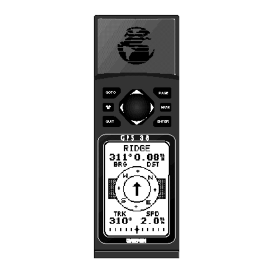
Page 18: Compass Page
CDI scale, see page 47. When you are one minute away from the destination (based on your current speed and track over the ground), the GPS 38 will alert you with a flashing on-screen message box. To view a message: 1. Press the key when the message box appears. -
Page 19: Page Sequence And Menu Page
Scrolling Through the Primary Pages Now that you’ve arrived ‘HOME’, let’s take a minute to see how the GPS 38’s primary pages work together. T h e GPS 38 features five primary pages, which are linked together in a chain. You can quickly scroll through the pages in either... -
Page 20: Clearing The Track Log/Power Off
GPS and probably know a little more than you think about how it works. We encourage you to experiment with the GPS 38 until it becomes an extension of your own navi- gation skills. If you encounter any problems using the unit or want to take advantage of the GPS 38’s more advanced... -
Page 21: Satellite Page
Indicator Satellite Number The GPS 38 Satellite Page displays the status of various receiver functions. The status information will help you understand what the GPS is doing at any given time, and tell you whether or not the receiver has calculated a posi- tion fix. -
Page 22: Receiver Status
(estimated position error, in feet or meters) at the top right. The status will show one of the following conditions: Searching— the GPS 38 is looking for any available satellites in view. AutoLocate — the GPS 38 is initializing and collect- ing new almanac data. -
Page 23: Battery Level
It’s always best to store your GPS with the batteries installed to preserve the internal memory and data. The GPS 38 features a self-charging lithium battery that continually maintains a full charge while bat- teries are installed. The lithium battery will maintain the internal memory for 3 months in the event that the batteries are removed or totally discharged. -
Page 24: Position Page
ENTER to confirm. Position Page The GPS 38’s Position Page shows you where you are, what direction you’re heading and how fast you are going (up to 99.9 mph), and is most useful when you are travel- ing without an active destination waypoint. -
Page 25: Creating And Using Waypoints
The GPS 38 allows you to mark, store and use up to 250 waypoints. A waypoint position can be entered by tak- ing an instant electronic fix or by manually entering a coor- dinate or range and bearing in reference to an existing way- point. -
Page 26: Waypoints Page
Waypoint Submenus The GPS 38 has three waypoint submenu Pages that let you manage a large number of waypoints quickly and effi- ciently. The nearest waypoints, waypoint list and waypoint definition pages are accessed through the Menu Page. -
Page 27: Waypoint List
Waypoint List Page The waypoint list page provides you with a complete list of all waypoints currently stored in the GPS 38. The total number of used and free waypoints is indicated above the waypoint list. From the waypoint list page, you can retrieve a waypoint definition page or delete all user- defined waypoints, or go to a selected waypoint. -
Page 28: Waypoint Definition Page
R E F E R E N C E Waypoint Definition Page Waypoint Definition Page Use the waypoint definition page to review, rename or delete stored waypoints and to create new waypoints manually. To create a new waypoint by manually entering coord i- nates or by referencing an existing waypoint, highlight the NEW? prompt and press... -
Page 29: Reference Waypoints
To create a new waypoint manually without knowing its position coordinates, you’ll need to enter its bearing and distance from an existing waypoint. The GPS 38 will then calculate the position coordinates for you. To create a new waypoint by referencing a stored waypoint: 1. -
Page 30: Editing Existing Waypoints
4. Press the key to confirm your changes. Waypoint Comments Each waypoint stored in the GPS 38 has a user-defined 16 character comment field. The default comment is the UTC date and time of the waypoint’s creation. To change or add a comment: 1. -
Page 31: Scanning Waypoints
To rename a stored waypoint: 1. Highlight the ‘RENAME?’ field and press 2. Enter the new waypoint name and press 3. Press the key to confirm your changes. To delete a stored waypoint: 1. Highlight the ‘DELETE?’ field and press 2. -
Page 32: Goto And Mob Mode
MOB will overwrite the pre- vious MOB waypoint. Selecting a GOTO Destination The GPS 38 provides four ways to navigate to a destina- tion: GOTO, MOB, TracBack and route navigation. The most basic method of selecting a destination is the GOTO... -
Page 33: Tracback Navigation
TracBack Navigation The third method of navigating to a destination is by using the GPS 38’s TracBack feature. The TracBack function allows you to quickly and easily retrace your path using the track log automatically stored in the receiver’s memory. The... - Page 34 Tips on Creating and Using the TracBack Feature The GPS 38’s TracBack feature is designed to help you quickly create and activate a route that follows your path back to a user-defined starting point. To get the most out of the TracBack feature, remember the following tips: •...
-
Page 35: Creating And Using Routes
Creating and Navigating Routes The last form of navigating to a destination with the GPS 38 is by creating a user-defined route. The route navi- gation feature lets you plan and navigate a course from one place to another using a set of pre-defined waypoints. -
Page 36: Route Definition Page
(see page 34). Route Definition Page The GPS 38 lets you create and store up to 20 routes of 30 waypoints each. Routes are created, copied, and edited through the route definition page, which is accessed through the Menu Page. -
Page 37: Clearing Routes
To create a route from the route definition page: 1. Highlight the route number field and press 2. Enter a route number and press the 3. Press to begin entry of a route comment. (Note that the default (first and last waypoint) comment will only appear if the comment field is blank). - Page 38 R E F E R E N C E Clearing, Activating & Inverting Routes Clearing a route only removes the waypoints from the route selected. The way- points used will remain in the receiver’s memory. To activate a route, high- light the ‘ACT?’...
-
Page 39: Active Route
Active Route Page Once a route has been activated, the active route page will appear, displaying the waypoint sequence of your route with the estimated time enroute (ETE) at your present speed and distance to each waypoint. As long as you are navigating an active route, the active route page will become part of the main page sequence of the unit. -
Page 40: On-Route Gotos
On-Route GOTOs At the beginning of this section, we mentioned that the GPS 38 will automatically select the route leg closest to your position as the active leg. This will give you steering guidance to the desired track of the active leg. If you would prefer to steer directly to a route waypoint, you can per- form an ‘on-route GOTO’... -
Page 41: Compass And Highway Page Steering Guidance
User-defined Navigation Pages Once you’ve selected a GOTO destination or activate a MOB or route, the GPS 38 will provide graphic steering guidance to the destination with one of two navigation pages: Compass Page •The Compass Page (the default navigation page) pro-... - Page 42 When you a re one minute away from the destination (based on your cur- rent speed and track over the ground), the GPS 38 will alert you with a flashing on-screen message box.
-
Page 43: Highway Page
Using the Highway Page The GPS 38’s Highway Page also provides graphic steer- ing guidance to a destination, with a greater emphasis on the straight line desired course and the distance and direc- tion you are off course. The bearing and distance to way-... -
Page 44: Map Plotting
49. Map Page The GPS 38 features a powerful real-time moving map that can do much more than just plot your course and route. The Map Page also provides you with a target cursor that will let you pan ahead to nearby waypoints, determine the distance and bearing to any map position and mark new waypoints while you navigate. - Page 45 Zooming and Panning There are three main functions you can perform from the Map Page— zooming, pointing and panning. Each of these functions has its own “field”, which may be selected and activated for use.Whenever the Map Page first appears, the zoom field (at the top left) is always highlighted.
-
Page 46: The Map
R E F E R E N C E Using The Cursor On The Map To stop panning, press the QUIT key. On-Screen Pointing The crosshair will “snap” to waypoints displayed on the map, which allows you to quickly review or go to the selected waypoint right from the Map Page. - Page 47 Using the Cursor to Mark and GOTO Waypoints During panning, the crosshair represents a target posi- tion right on the moving map, with the range and bearing to the target displayed at the top corners of the screen. You can also use the target crosshair to mark a new waypoint position or as a GOTO destination right from the map field.
-
Page 48: Menu Page And Auxiliary Functions
Message Page The message page displays all current messages in the GPS 38. There are two types of messages: temporary alerts (eg. approaching a waypoint) and condition alerts (eg. bat- tery power is low). All messages are initially indicated by a flashing on-screen box. - Page 49 The first setup page is the system setup page, which is used to select the operating mode, time offset and screen preferences. The GPS 38 has three operating modes: • Normal Mode operates the unit at maximum perfor- mance, and provides a battery life up to 12 hours on alkaline batteries.
-
Page 50: Setting Time
2. Use the arrow keypad to select the 12 or 24 hour option. 3. Press to confirm. Screen Contrast The GPS 38 features adjustable screen contrast for opti- mum viewing in any condition. The screen contrast is set by using an on-screen bar scale. To set the screen contrast: 1. -
Page 51: Navigation Setup
CDI scale, and distance, speed, and heading information. Position Formats The default position setting for the GPS 38 is latitude and longitude in degrees and minutes (hdddºmm.mmm’). You may also select degrees, minutes and seconds (hdddºmm’ss.s’’);... -
Page 52: Units Of Measure
Units of Measure The GPS 38 lets you select statute (default), nautical or metric units of measure for all speed and distance fields. To change the unit of measure: 1. Highlight the ‘UNITS’ field and press the 2. -
Page 53: Track Log Display
‘000’. Track Log Setup Page The track log setup page lets you manage the GPS 38’ s tracking data. From this page, you can select whether or not to record a track and define how it is recorded. -
Page 54: Navigation Page
R E F E R E N C E Navigation Page Setup Track Log Page Turning off the track record- ing option will prevent you f rom using the Tr a c B a c k feature. To clear the track log, con- firm the ‘Yes?’... -
Page 55: Interface Setup
Interface Setup The GPS 38’s interface setup page lets you specify the interfacing formats for connecting external devices. There are five interface options: GRMN/GRMN, None/None, None/NMEA, RTCM/None, and RTCM/NMEA. Each option lists the input format first, followed by the output format. -
Page 56: Dgps Interface
The RTCM/NMEA selection controls the GARMIN GBR- 21 differential beacon receiver. Once a RTCM setting has been selected, the GPS 38 will automatically try to tune the last frequency and bit rate you selected or will switch to the default frequency of 304.0 kHz with a bit rate of 100 bps if no previous beacon has been tuned. -
Page 57: Simulator Mode
The GPS 38 does not track satellites in simulator mode. Although you can create and save waypoints and routes while using the simulator mode, never attempt to use the simulator mode for actual navi- gation. The GPS 38 will always power up in the Normal mode. key. key. -
Page 58: Appendix A-Messages/Time Offsets
500 meters due to poor satellite geometry or data quality. You should check other navigational sources to verify the position indicated. Already Exists—The name you are entering already exists in the GPS 38’ s memory. Approaching—You are one minute away from reaching a destination waypoint. -
Page 59: Time Offsets
RTCM Input has Failed—DGPS data being received has been lost. You are no longer receiving the beacon signal. Searching the Sky—The GPS 38 is in searching the sky for almanac data or the unit is in AutoLocate TM mode. Stored Data was Lost—All waypoints, routes, time and almanac data has been lost due to battery failure or clearing the receiver’s memory. -
Page 60: Appendix B-Map Datums
The following list shows the map datums available for the GPS 38. Menu Page abbreviations are listed first, fol- lowed by the corresponding map datum name and area. The default map datum for the GPS 38 is WGS 84. Adindan- Ethiopia, Mali, Easter Isld 67... - Page 61 Massawa Massawa- Eritrea (Ethiopia) Merchich Merchich- Morocco Midway Ast ‘61 Midway Astro ‘61- Midway Minna Minna- Nigeria NAD27 Alaska North American 1927- Alaska NAD27 Bahamas North American 1927- Bahamas (excluding San Salvador Island) NAD27 Canada North American 1927- Canada and Newfoundland NAD27 Canal Zone North Am.
-
Page 62: Appendix C-Specifications And Wiring
.75 watts Up to 12 hours (normal mode) Up to 20 hours (battery saver mode) you’re using the GPS 38 in below freezing temperatures, use lithium batteries for longer battery life. Extensive use of screen backlighting will significantly reduce battery life. -
Page 63: Specifications
(UNIT VIEW) Three optional cables are available to connect the GPS 38 to an external power source or interface with another unit or PC: • Cigarette Lighter Adapter (Part No. 010-10084-00) — Allows connection to a 12 volt DC cigarette lighter plug. -
Page 64: Appendix D-Accessories
APPENDIX D Index 2D Navigation ....18 3D Navigation ....18 Acquiring Satellites ... . .6 Activating and Inverting Routes . -
Page 65: Appendix E-Index
Map Datums ....47, 56 Map Page ....12 Map Setup and Orientation ..48 Mark /GOTO Wypts with Cursor . - Page 66 APPENDIX D Index Warranty ....63 Waypoints Waypoint (defined) ...2 Waypoint Comments ..26 Waypoint Definition Page .
- Page 67 The unit should be securely packaged with the tracking number clearly marked on the outside of the package, and sent freight prepaid and insured to a GARMIN warranty service station. A copy of the original sales receipt is required as the proof of purchase for warranty repairs.
- Page 68 ® © 1997 GARMIN Corporation 1200 E. 151st Street, Olathe, KS USA 66062 GARMIN (Europe) Ltd. Unit 5, The Quadrangle Abbey Park, Romsey, UK SO51 9AQ Part Number 190-00112-00 Rev. B Printed in Taiwan...