Garmin GPSMAP 60CSx Owner's Manual
Garmin gps with sensors and maps owner's manual gpsmap 60csx
Hide thumbs
Also See for GPSMAP 60CSx:
- Owner's manual (116 pages) ,
- Manual de l'utilisateur (116 pages) ,
- Quick start manual (2 pages)
Table of Contents
Advertisement
Quick Links
Advertisement
Table of Contents

Related Manuals for Garmin GPSMAP 60CSx


Summary of Contents for Garmin GPSMAP 60CSx
- Page 1 GPSMAP 60CSx ® with sensors and maps owner’s manual...
- Page 2 Garmin. Garmin hereby grants permission to download a single copy of this manual onto a hard drive or other electronic storage medium...
-
Page 3: About This Manual
Thank you for choosing the Garmin 60CSx. The GPSMAP 60CSx uses the proven performance of Garmin GPS and full-featured mapping to create an unsurpassed portable GPS receiver. Compare the contents of this package with the packing list on the box. If any pieces are missing, contact your Garmin dealer immediately. -
Page 4: Table Of Contents
Software License Agreement ... v Product Registration ... v Contact Garmin ...v Tell Us What You Think ...v Caring for the GPSMAP 60CSx ... vi Cleaning the Case ... vi Cleaning the Screen ... vi Storage ... vi Water Immersion ... vi Warning ... - Page 5 Guidance Text ...42 Setting up the Map Page ...43 Measuring Distance ...46 Turning Declutter On or Off ...47 Restoring Defaults ...47 GPSMAP 60CSx Owner’s Manual ntroductIon Compass Page ... 48 Using the Electronic Compass ...49 Compass Page Options ...51 Sight ‘N Go Navigation ...51 Using the Course Pointer or Bearing Pointer ...53...
- Page 6 Power ...91 Interfacing ... 92 Data Field Definitions ... 93 Optional Accessories ... 95 Connecting Your GPSMAP 60CSx to a ... Computer ... 96 What Is WAAS/EGNOS? ... 97 Map Datums and Location Formats ... 99 What Are Map Datums? ...99 What Is a Location Format? ...99...
-
Page 7: Software License Agreement
Software License Agreement BY USING THE GPSMAP 60CSx, YOU AGREE TO BE BOUND BY THE TERMS AND CONDITIONS OF THE FOLLOWING SOFTWARE LICENSE AGREEMENT. PLEASE READ THIS AGREEMENT CAREFULLY. Garmin grants you a limited license to use the software embedded in this device (the “Software”) in binary executable form in the normal operation of the product. -
Page 8: Caring For The Gpsmap 60Csx
Avoid chemical cleaners and solvents that may damage plastic components. Cleaning the Screen Clean the GPSMAP 60CSx screen using a soft, clean, lint-free cloth. Use water, isopropyl alcohol, or eyeglass cleaner if needed. If these are used, apply the liquid to the cloth, and then gently wipe the screen with the moistened cloth. -
Page 9: Warning
This Notice is provided in accordance with California’s Proposition 65. See com/prop65 for more information. GPSMAP 60CSx Owner’s Manual sources, including information from street signs, visual sightings, and maps. For safety, always resolve any discrepancies or questions before continuing navigation and defer to posted road signs. -
Page 10: Important Information
Other Garmin dashboard or friction mounting options should be used. Garmin does not take any responsibility for any fines, penalties, or damages that may be incurred as a result of disregarding this notice or as a result of any other state or local law or ordinance relating to use of the unit. -
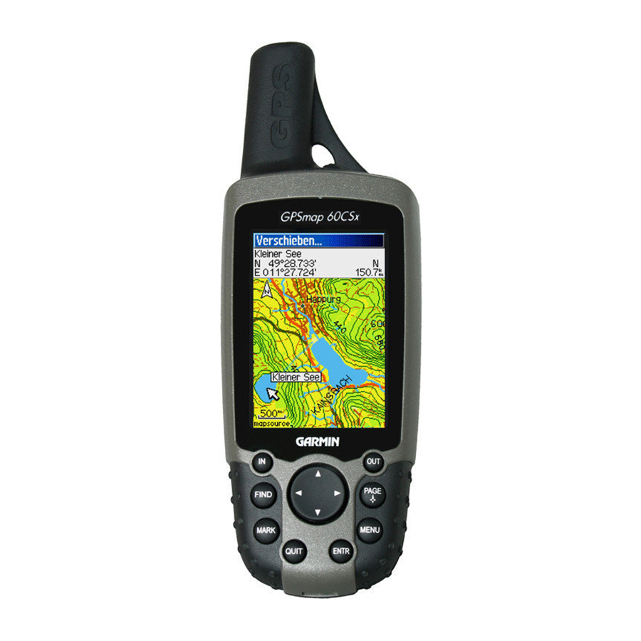
Page 11: Getting Started
Unit Overview Power key display screen GPSmap 60CSx GPSMAP 60CSx Owner’s Manual ettInG tarted Auxiliary GPS antenna connector (under weather cap) USB connector port (under weather cap) Carry lanyard attachment slot Keypad ettIng tArted vervIew Internal antenna External Data/ Auxiliary Power Port... -
Page 12: Installing The Batteries
Installing the Batteries The GPSMAP 60CSx operates on two AA batteries (not included), which are located in the back of the unit. You can use Alkaline or NiMH batteries. See page 67 for information on setting the battery type. -
Page 13: Using The Gpsmap 60Csx Keypad
Using the GPSMAP 60CSx Keypad POWER Key • Press and hold to turn the unit on or off. • Press and release to adjust the backlighting. IN/OUT Zoom Keys • Press to zoom in or out on the Map Page. -
Page 14: Turning On The Gpsmap 60Csx
1. Press and hold the POWER key. When the unit turns on, a tone sounds and the Introduction Page appears, followed by the Satellite Page. 2. To turn off the GPSMAP 60CSx, press and hold the POWER key again. Welcome Page Satellite Page... -
Page 15: Initializing The Gps Receiver
Initializing the GPS Receiver The first time you turn on your GPSMAP 60CSx, the GPS receiver must collect satellite data and establish its current location. To ensure proper initialization, the GPSMAP 60CSx is shipped from the factory in AutoLocate mode, which allows the receiver to “find itself”... -
Page 16: Using The Gpsmap 60Csx
Using the GPSMAP 60CSx This section explains how to enter and select information with the GPSMAP 60CSx. Understanding Terms As you progress through this owner’s manual, you are directed to press a specific key or highlight a field on the screen. -
Page 17: Selecting Options And Entering Data
Using the Status Bar At the top of each page, the status bar provides status information for several unit features. Status Bar GPSMAP 60CSx Owner’s Manual ettIng tArted • Power to the unit is provided by either batteries or from an auxiliary source (AC, DC or USB Adapter). -
Page 18: On-Screen Messages
Map data transfer requires the USB Interface Cable provided with the unit to transfer MapSource data from a PC to the microSD card in the GPSMAP 60CSx. To transfer data to the microSD card you can use the USB Mass Storage feature explained on You can purchase high capacity microSD cards at your electronics supplier. -
Page 19: Transferring Data To A Microsd Card
1. Lift the weather cover from the USB port on the upper back of the unit. It recommended that you use the USB port rather than the Serial Connection port for faster data transfer. GPSMAP 60CSx Owner’s Manual ettIng tArted 2. Connect the USB cable provided with the unit to the USB port on your PC and to the mini- USB port on the back of the unit. -
Page 20: Basic Operation
This section explains some of the more common operations you can perform with your GPSMAP 60CSx including creating and using waypoints, using the Find Menu, and how to create and use tracks and routes. Creating and Using Waypoints Waypoints are locations or landmarks you record and store in your GPS. -
Page 21: Creating Waypoints Using The Map
4. To change any information on the Waypoint Page, highlight the appropriate field, and press ENTER to open the on-screen keypad. After entering and confirming your changes, highlight OK, and press ENTER. GPSMAP 60CSx Owner’s Manual AsIc PerAtIon Information page for a Information page for a... -
Page 22: Editing Waypoints
3. Select the waypoint you want to delete, and press ENTER. The Waypoint Page opens. 4. Highlight the Delete button, and press ENTER. A confirmation message appears. 5. Highlight Yes, and press ENTER to delete the waypoint. Note: When you delete a waypoint, you cannot recover it from the unit. GPSMAP 60CSx Owner’s Manual... -
Page 23: Averaging The Waypoint's Location
ENTER. Original location Moving a waypoint GPSMAP 60CSx Owner’s Manual Averaging the Waypoint’s Location You can average a new waypoint location over time to produce a more accurate location. Note: You must have a GPS Satellite fix before you can average a waypoint’s location. -
Page 24: Projecting A Waypoint
6. Enter the distance and bearing to the projected waypoint in the appropriate fields at the bottom of the page, and press QUIT when finished. Enter bearing distance Project Waypoint Projected waypoint Page GPSMAP 60CSx Owner’s Manual on the map... -
Page 25: Proximity Waypoints
4. Select a waypoint from the Waypoints List or from any other group of map points, and press ENTER to open the information page for the item. GPSMAP 60CSx Owner’s Manual 5. With the Use button highlighted, press ENTER to add the point to the list on the Proximity Waypoints Page. -
Page 26: Man Overboard (Mob)
MOB point. Using the Find Menu Use the Find Menu to search for waypoints, cities, and exits included in the GPSMAP 60CSx basemap. You can also find saved waypoint and geocache points. Additional icons appear depending on the optional BlueChart or MapSource data loaded to the unit. -
Page 27: Find By Name
To search the entire database, select the All Points of Interest icon, and press ENTER. 3. Press MENU, highlight Find By Name, and press ENTER. GPSMAP 60CSx Owner’s Manual AsIc PerAtIon 4. Use the ROCKER and ENTER key to operate the on-screen keypad and enter the name of the location you want to find. -
Page 28: Recent Finds
• Average Location—sample a waypoint location over time and average the result for a more accurate location reference. See for more information. • Project Waypoint—create a new waypoint referencing another location by entering page 13 GPSMAP 60CSx Owner’s Manual... - Page 29 • Map Information—shows the name of the map from which the map item originated. GPSMAP 60CSx Owner’s Manual To find an item near another item: 1. Press FIND to open the Find Menu. 2. Select an icon on the Find Menu, and press ENTER.
-
Page 30: Finding A Waypoint
Finding a Geocache Use the Geocache icon to view the list of geocache locations created using your GPSMAP 60CSx or downloaded from your computer. A geocache location is a waypoint with a special geocache symbol assigned to give special significance and to allow it to be separated from others on the waypoints list. -
Page 31: Finding A City
When a geocache is found, the unit marks the cache as found, logs an entry into the calendar, and provide an option that, when activated, shows the nearest cache. GPSMAP 60CSx Owner’s Manual AsIc PerAtIon Finding a City Use the Cities icon on the Find Menu to find any city listed in the mapping database (either in the basemap or from downloaded detailed mapping data). -
Page 32: Finding An Interstate Exit
If you downloaded optional detailed mapping data, use the Addresses icon on the Find Menu to find an address. When you enter the street number, street name, and city, the find feature matches that data with addresses in database. GPSMAP 60CSx Owner’s Manual Available services the map... - Page 33 Addresses icon Addresses Page GPSMAP 60CSx Owner’s Manual AsIc PerAtIon 3. Highlight the <Enter Number> field, and press ENTER. 4. Type the street number using the on-screen keypad.
-
Page 34: Finding An Intersection
Searching for a Point of Interest If you downloaded optional MapSource detailed mapping, you can use the All Points of Interest icon on the Find Menu to locate a nearby restaurant, lodging, landmark, public building, and so on. GPSMAP 60CSx Owner’s Manual... -
Page 35: Poi Loader & Custom Points Of Interest
Options Menu. POI Loader & Custom Points of Interest You can create your own category for points of interest by using the Garmin POI Loader utility, downloadable from the Garmin Web site: garmin.com/products/poiloader/. Follow the Help instructions to use the POI Loader. -
Page 36: Using Tracks
1. Press MENU twice to open the Main Menu. 2. Select the Tracks icon, and press ENTER to open the Tracks Page. 3. Highlight the Setup button, and press ENTER to open the Track Log Setup Page. Percentage of memory used Data Card Option GPSMAP 60CSx Owner’s Manual... - Page 37 Track logs on the data card are .gpx GPS position data files, and are not used by your unit. To learn more about .gpx files, search the Web for subjects titled GPX or GPS Exchange Format. GPSMAP 60CSx Owner’s Manual AsIc PerAtIon To save the entire track log: 1.
- Page 38 Recording continues until the card is filled. Because these track logs share card space with MapSource mapping data, space for additional map storage is reduced. GPSMAP 60CSx Owner’s Manual Options Menu...
- Page 39 USB Mass Storage feature as explained on page 68. You can open the track logs using Garmin MapSource or another .gpx file- compatible application. 4. To delete these track logs from the microSD card, highlight individual logs, and then press ENTER.
-
Page 40: Track Profiles
When these types of maps are available, a Use Map Data - Use Track Data option menu appears when you select Profile. Refer to the Garmin Web site, www.garmin.com/cartography/ontheTrail/, for more information about MapSource U.S. Topo 24K maps. -
Page 41: Navigating A Saved Track
TracBack. The Map Page opens with directions to the first turn on the track at the top of the page. GPSMAP 60CSx Owner’s Manual AsIc PerAtIon 4. Move in the direction of the first turn. When... -
Page 42: Creating And Using Routes
PerAtIon Creating and Using Routes a Route is a sequence of intermediate waypoints that lead you to your final destination. The GPSMAP 60CSx lets you store 50 routes with up to 250 points each. Routes icon Setting up a route... -
Page 43: Navigating A Route
5. To stop navigating, press MENU, select Stop Navigation, and press ENTER. Using the Follow Roads option on the Routing Setup Page increases the number of turns and shows an GPSMAP 60CSx Owner’s Manual AsIc PerAtIon Active Route Page with a list of turns. If you selected the Off Road option, you can view only the list of points for a route from the Active Route Page. -
Page 44: Editing A Route
1. Press MENU twice to open the Main Menu. 2. Highlight the Routes icon, and press ENTER to open the Routes Page. 3. Select a saved route, and press ENTER. Route Page GPSMAP 60CSx Owner’s Manual Enter a new route name... - Page 45 Distance) when advancing to the next point. Select Distance to enter a radius so that when you are within the entered distance, the 60CSx leads you to the next point on your route. Select Manual to transition to the next waypoint anytime while navigating a route.
-
Page 46: Vertical Profiles Of Routes
Menu key. 2. Select Profile and press ENTER to display the route profile, answer the “use data” prompt and press ENTER. Note: Profiles are available only if Garmin MapSource U.S. Topo 24K map data is used. Options Menu Options Menu Route Vertical Route Vertical Profile using U.S. -
Page 47: Main
The GPSMAP 60CSx has six main pages: Satellite Page, Trip Computer Page, Map Page, Compass Page, Altimeter Page, and the Main Menu. You can cycle through these pages by pressing the PAGE key to move forward or pressing the QUIT key to reverse. Add more pages from the Main Menu. (See Route Page appears only when you are actively navigating. -
Page 48: Satellite Page
New Location—use if you have moved the unit more than 600 miles and you are having trouble locking onto satellite signals. GPS Elevation— your GPS determined elevation. GPSMAP 60CSx Owner’s Manual... -
Page 49: Map Page
Map Page The GPSMAP 60CSx comes with a built-in basemap that includes a database of cities, interstates, state and county highways, exit information, and lake and river outlines. The standard basemap can be enhanced using MapSource or BlueChart data. Two map operating modes, position mode and pan mode, determine what cartography is shown on the map display. -
Page 50: Using Additional Map Data
Appendix. Using Additional Map Data Optional MapSource mapping data enhances the versatility of your GPSMAP 60CSx. With MapSource data, you can view listings of nearby restaurants, lodging, shopping centers, attractions, and entertainment, and you can retrieve addresses and phone numbers for any listed location. -
Page 51: Changing The Zoom Range
“overzoom” appears under the zoom range. When using MapSource maps, “mapsource” appears below the scale. Map ranges GPSMAP 60CSx Owner’s Manual Map Orientation There are two map orientation options: North Up orients the map like a paper map. Track Up orients the map in the direction of travel. -
Page 52: Guidance Text
If you select Always Show, a message of some type always appears whether or not you are navigating. If you select Show When Navigating, a guidance message appears until you select Stop Navigation from the Options Menu. Guidance text GPSMAP 60CSx Owner’s Manual... -
Page 53: Setting Up The Map Page
Each Map Setup Page has a sub- menu of general options. To access this menu, press the MENU key while viewing the page. GPSMAP 60CSx Owner’s Manual Map Setup – General Page The Map Setup – General Page contains the settings for Orientation, Below, Auto Zoom, Detail, and Lock On Road. - Page 54 Use the Map Setup – Points Page to set the map scale at which Map Points, User Waypoints, Street Label, and Land Cover appear on the Map Page. Select Auto, Off, or a specific zoom level. Map Setup – Points Page GPSMAP 60CSx Owner’s Manual...
- Page 55 ENTER to show it on the map display or turn it off. Map Setup – Information Page GPSMAP 60CSx Owner’s Manual Press MENU to view options for showing maps. Map Setup – Marine Page Use the Map Setup – Marine Page to customize...
-
Page 56: Measuring Distance
The distance between the two points is shown in the upper-right corner of the Map Page. 5. Press QUIT to cancel. Push pin indicating the beginning point of the measurement GPSMAP 60CSx Owner’s Manual Measured distance End point of measurement labeled REF... -
Page 57: Turning Declutter On Or Off
2. Highlight Turn Declutter On, and press ENTER. To turn Declutter off, press MENU, select Turn Declutter Off, and press ENTER. GPSMAP 60CSx Owner’s Manual Map with Declutter off Map with Declutter on Restoring Defaults Use the Restore Defaults option to return the map settings to factory settings. -
Page 58: Compass Page
The Compass ring moves to indicate North Course Pointer orientation. The bearing pointer indicates the direction to your destination. The course pointer indicates your course of travel and the distance you drift off course. Bearing Pointer GPSMAP 60CSx Owner’s Manual... -
Page 59: Using The Electronic Compass
When it is turned off, the unit uses the GPS receiver for navigation. 2. Hold the GPSMAP 60CSx level to get an accurate electronic compass reading. (You obtain the most accurate reading if the compass has been recently calibrated. -
Page 60: Calibrating The Electronic Compass
ENTER to set the time delay from the time options list. Calibrating the Electronic Compass When you first use the GPSMAP 60CSx or after you install new batteries, you have to calibrate the electronic compass outdoors. If not held level or you... -
Page 61: Compass Page Options
• Course or Bearing Pointer—toggles between the course pointer and the bearing pointer. GPSMAP 60CSx Owner’s Manual • Data Fields—allows you to select from 2, 3 or 4 data fields that appear on the Compass Page. • Change Data Fields—allows you to select the type of data you want to show in the data fields. - Page 62 Map Page and begin navigation to the projected waypoint. The Compass Page shows a bearing pointer for guidance. To stop navigation: 1. Press MENU to open the Map Page Options Menu. 2. Highlight Stop Navigation, and press ENTER. GPSMAP 60CSx Owner’s Manual...
-
Page 63: Using The Course Pointer Or Bearing Pointer
(right or left) according to the scale shown at the edge of the compass ring. GPSMAP 60CSx Owner’s Manual The bearing pointer always indicates the direction to your destination from your current location. Move to the right or left to get back on course. This is most efficient if you are navigating on water or where there are no major obstacles in your path. -
Page 64: Data Fields
1. Press MENU to open the Compass Page Options Menu. 2. Highlight Data Field, and press ENTER. The Show sub-menu appears. 3. Select the number of data fields you want to show on the Compass Page and press ENTER. 4 Data Fields GPSMAP 60CSx Owner’s Manual... -
Page 65: Altimeter Page
1. Press MENU to open the Compass Page Options Menu. 2. Highlight Restore Defaults, and press ENTER to return the page to factory settings. GPSMAP 60CSx Owner’s Manual Ages Altimeter Page The Altimeter Page shows you the current elevation, rate of ascent or descent, a profile of elevation changes over distance or time, or a profile of pressure changes over time. -
Page 66: Altimeter Page Options
• Calibrate Altimeter—If you know the correct elevation for your location, you can increase the accuracy of the altimeter using the “Calibrate Altimeter” option. • Restore Defaults—clears recorded data from the page and begins recording new data. GPSMAP 60CSx Owner’s Manual... -
Page 67: Plot Over Time Or Distance
Elevation over Pressure over Distance plot GPSMAP 60CSx Owner’s Manual View Pressure or Elevation Plots Select the View Elevation Plot option to plot a profile of elevation changes that occur as you navigate over a set distance or period of time. Select View Pressure Plot to view a record of changes in barometric pressure for a set period of time. -
Page 68: Zoom Ranges
Pressing up or down on the ROCKER while a plot is displayed switches the screen to the Zoom Range mode. 3. Press ENTER to return to the Plot Page. Time plot GPSMAP 60CSx Owner’s Manual... -
Page 69: View Points
Red crosshairs View point for an View point for a altitude plot pressure plot GPSMAP 60CSx Owner’s Manual Ages To use the View Points option: 1. Press MENU to open the Altimeter Page Options Menu. 2. Select View Pressure Plot or View Elevation Plot, and press ENTER to open the Plot Page. -
Page 70: Resetting Data
5. Highlight Apply, and press ENTER to reset the selected options. 6. To reset all categories shown on the page, highlight Select All, and press ENTER. Then repeat step 5 above. GPSMAP 60CSx Owner’s Manual... -
Page 71: Calibrating The Altimeter
Calibrating the Altimeter Because the GPSMAP 60CSx relies on the barometric pressure to determine the elevation, and the pressure at any given elevation can fluctuate, you can calibrate the altimeter to increase its accuracy. You must know the elevation or pressure at your current location. -
Page 72: Changing The Data Fields
ENTER to view a list of available data field options. 4. Press up or down on the ROCKER to highlight an option, and press ENTER to place it in the data field. Data field options 93.) Data fields GPSMAP 60CSx Owner’s Manual... -
Page 73: Trip Computer Page
Map Page. (See page 40 for details.) GPSMAP 60CSx Owner’s Manual Ages Trip Computer Page Options Menu Press MENU to view the following options: • Reset—because you want to record new data for each trip, a Reset option is available. -
Page 74: Main Menu
1. Press MENU twice to open the Main Menu. 2. Select the Tracks icon, and press ENTER. 3. Highlight the Setup button, and press ENTER to open the Track Log Setup Page. Tracks Page Track Log Setup GPSMAP 60CSx Owner’s Manual GPSMAP 60CSx Owner’s Manual... -
Page 75: Route Page
Use the In and Out keys to change the five scale settings for zooming in or out on the highway. GPSMAP 60CSx Owner’s Manual To navigate using the Highway Page: 1. While navigating, press the PAGE key to cycle... -
Page 76: Setup Menu Page
(Stay On) or turns off (Turn Off) when external power is removed from the unit. • Proximity Alarms—indicates whether custom points of interest (POI’s) proximity alarms are on or off. page 97 for WAAS information). GPSMAP 60CSx Owner’s Manual... -
Page 77: Display Setup
Display icon, and press ENTER. • Display Mode—sets the display to Day, Night, or Auto mode. Select Auto to automatically GPSMAP 60CSx Owner’s Manual switch from day to night at sunset and change back at sunrise. • Daytime Color Scheme/Nighttime Color Scheme—sets the color scheme to use when... -
Page 78: Interface Setup
USB cable. 2. Highlight the on-screen USB Mass Storage button and press ENTER. 3. Observe an illustration of the GPSMAP 60CSx connected to a computer and an Unplug or Eject icon shown on a PC’s system tray or a storage device icon for the microSD on a Macintosh 4. - Page 79 GPSMAP 60CSx removable storage device. 4. Select Edit > Paste. The file appears in the list of files on the GPSMAP 60CSx microSD card. 5. For a Macintosh, click and drag the desired file into the microSD card directory.
-
Page 80: Tones Setup
ENTER. Select Insert, then select a page from the list, and press ENTER. 3. To remove a page, highlight the page and press ENTER. Select Remove, and press ENTER. Map Page Setup The Map Page Setup information is located on page GPSMAP 60CSx Owner’s Manual... -
Page 81: Routing Setup
Routing Setup Page Follow Road Options • Guidance Method—allows the unit to calculate routes using the preferences below: GPSMAP 60CSx Owner’s Manual Prompted—prompts you to select a preference before the route is calculated. Follow Road—creates a route that overlays the roads shown on the map. -
Page 82: Geocache Setup
Geocache Setup Use the Geocache Setup Page to find and record items hidden at geographic locations. See the Garmin Web site (www.garmin.com) for details and how to download geocache locations from the Internet. Note: Before setting up and placing physical... -
Page 83: Marine Setup
ENTER. • Time Format—sets 12 or 24 hour format. • Time Zone—sets the time zone for your city so the GPSMAP 60CSx shows the correct local time. Select Other to manually enter a Universal Time Coordinate. etuP... -
Page 84: Units Setup
Fathoms, or Meters) to show water depth. (Requires interface to other devices or marine chart data) • Temperature—sets the unit of measurement (Fahrenheit or Celsius) to show temperature. • Pressure—sets the unit of measurement (Inches, Millibars, or Hectopascals) to show pressure. GPSMAP 60CSx Owner’s Manual page... -
Page 85: Heading Setup
On the Setup Menu Page, highlight the Heading icon, and press ENTER. • Display—sets the value (Cardinal Letters, Degrees, or Mils) to show your heading. GPSMAP 60CSx Owner’s Manual eAdIng etuP • North Reference—provides headings based on a true, magnetic, grid, or specific user value north reference. -
Page 86: Altimeter Setup
Enter the correct elevation: this requires a reliable source for determining the elevation for your current location. Enter the correct pressure: this requires a reliable source to determine the accurate barometric pressure at your current location. GPSMAP 60CSx Owner’s Manual... -
Page 87: Welcome Setup
Welcome Setup Use the Welcome Setup Page to insert a message, such as ownership information, that appears when you turn on your GPSMAP 60CSx. Welcome message Welcome message GPSMAP 60CSx Owner’s Manual To access the Welcome Setup Page: On the Setup Menu Page, highlight the Welcome Message icon, and press ENTER. -
Page 88: Jumpmaster
A desired impact point (DIP) must be set for all jumps. This is a waypoint that you have previously marked or another location from the Find Menu where you want to land. GPSMAP 60CSx Owner’s Manual... - Page 89 (DZSTL) monitoring the course of a Pilot Balloon (PiBal) released from the ground at the DIP and wind streamers dropped from aircraft once the HARP is calculated. GPSMAP 60CSx Owner’s Manual Jumpmaster is capable of handling doglegs in wind direction. Wind Setup...
- Page 90 K-open and K-freefall. Static jumps use K-static. K-values are based on the parachute canopy rating. Each parachute should be labeled with a K value. Common values may range from 3.0 for K-freefall to 48.0+ for HAHO K-open. Constant Setup Constant Setup GPSMAP 60CSx Owner’s Manual...
- Page 91 Select Restore Defaults from the Option Menu of this page to reset the values. GPSMAP 60CSx Owner’s Manual The following is a list of abbreviations and acronyms commonly used and relate specifically to this feature: AGL—(Above Ground Level) indicates the altitude measurement.
-
Page 92: Proximity Waypoints
2. Select the Calendar icon, and press ENTER. The Calendar Page opens with the current week shown. 3. Use the ROCKER to highlight the day you want to add waypoints to, and press ENTER to show the Page for that day. page GPSMAP 60CSx Owner’s Manual... -
Page 93: Calculator
ROCKER to make your choice. GPSMAP 60CSx Owner’s Manual Calculator Select the Calculator icon to use your GPSMAP 60CSx as a calculator. You can select either a standard or scientific calculator and degrees or radians from the for details on Options Menu. -
Page 94: Stopwatch
Stopwatch Select the Stopwatch icon to use the GPSMAP 60CSx as a stopwatch, which includes a lap timer. You can also have the unit record the lap time based on distance. To access the stopwatch: 1. Press MENU twice to open the Main Menu. -
Page 95: Sun And Moon
The button to the left animates the display of the sun and moon. The center button GPSMAP 60CSx Owner’s Manual animates more rapidly, showing the phases of the moon. The right button stops animation. -
Page 96: Hunt And Fish
ENTER. The Location field now shows the name of the find item. 5. To return to the current date, press the MENU key, and then press ENTER. Hunt and Fish Page Hunt and Fish Page GPSMAP 60CSx Owner’s Manual... -
Page 97: Games Menu
2. Select the Games icon, and press ENTER. 3. Use the ROCKER to highlight a game, and press ENTER. A brief description of each game appears. GPSMAP 60CSx Owner’s Manual 4. Press the QUIT key, and highlight Yes, when prompted, to stop playing. WaRNiNg: When playing any of the virtual... -
Page 98: Virtua Maze
60 yards by 90 yards (about the size of an American football field). The difficulty levels are: Easy, Normal and Hard. These levels determine how often gekos appear. The pace quickens and values vary as difficulty levels increase. GPSMAP 60CSx Owner’s Manual... -
Page 99: Nibbons
The map is stationary and north is always up. Orient map “Ship GPSMAP 60CSx Owner’s Manual Up” rotates the virtual world around your ship. Your ship always points up. Press ENTER to start, and blast away. - Page 100 5. To defeat the dragon, press ENTER to place an arrow in a shaded platform. Use the ROCKER to point, and press ENTER to shoot. Game Symbols Game Symbols Pit Warning Pit Warning Player Player Dragon Near Dragon Near Dragon Dragon Arrow Arrow GPSMAP 60CSx Owner’s Manual...
-
Page 101: Appendix
Rugged, fully gasketed, water resistant, IEC-529, IPX7 Temp Range: 5 to 158 F (-15 to 70 *The temperature rating of the GPSMAP 60CSx may exceed the usable range of some batteries. Some batteries can rupture at high temperatures. Performance Receiver:... -
Page 102: Interfacing
Use the USB data cable provided with the product or optional power/data serial port cable with auxiliary AC power adapter or power/data serial port of Lat/Lon minutes. cable with bare wire leads. Refer to the Garmin Web site: www.garmin.com/products/gpsmap60csx/ Optional Power/Data Serial Port Cable with bare wire leads... -
Page 103: Data Field Definitions
Descent - Maximum—the maximum descent rate in feet per minute. Descent - Total—the total distance descended. Distance - To Next—the distance to the next point on a route. GPSMAP 60CSx Owner’s Manual PPendIx Distance - To Destination—the entire distance to the end of a route. - Page 104 Water Speed—the measurement of speed over water from interfaced devices. Water Temperature—the measurement of water tempera- ture from interfaced devices. Waypoint—At Destination—the last point on a route; your destination. Waypoint—At Next—the next point on your route. GPSMAP 60CSx Owner’s Manual...
-
Page 105: Optional Accessories
Bicycle Handlebar Mount—allows installation on a bicycle handlebar. Battery Pack—rechargeable, NiMH, AA-battery kit, USA type receptacle. Retractable Lanyard—retains unit on a tether. For a complete list of available accessories for use with the GPSMAP 60CSx, refer to the Garmin Web site: www.garmin.com/products/gpsmap60csx/. PtIonAl ccessorIes www.garmin. -
Page 106: Connecting Your Gpsmap 60Csx To A
MapSource Trip and Waypoint Manager software that came with your GPSMAP 60CSx. When you initially connect the GPSMAP 60CSx to a USB port, your computer might prompt you to locate the destination of the drivers for the device. The default directory is c:\Garmin.You only need to install the... -
Page 107: What Is Waas/Egnos
SBAS system should be capable of providing your GPS unit with increased accuracy at any location in the world. Currently, enabling WAAS on your GPSMAP 60CSx in regions that are not supported by ground stations may not improve accuracy, even when receiving signals from an SBAS satellite. -
Page 108: Loran Td Setup
You must know your GRI chain number and secondary stations to create a LORAN TD position. For more information, read our LORAN TD Position Format Handbook, available on the Garmin Web site, at www.garmin.com/support/userManual.jsp. Loran TD Setup Page Loran TD Setup Page... -
Page 109: Map Datums And Location Formats
Every chart has a map datum reference and the GPSMAP 60CSx can be set to match most commonly used datum data. If you are navigating and comparing the GPS... -
Page 110: Fcc Compliance
Hereby, Garmin declares that this GPSMAP 60CSx is in compliance with the essential requirements and other relevant provisions of Directive 1999/5/EC. To view the full Declaration of Conformity, see the Garmin Web site for your Garmin product: www.garmin.com/products/gpsmap60csx/. Click Manuals and then select the Declaration of Conformity link. -
Page 111: Limited Warranty
PRODUCT OR FROM DEFECTS IN THE PRODUCT. Some states do not allow the exclusion of incidental or consequential damages, so the above limitations may not apply to you. Garmin retains the exclusive right to repair or replace the unit GPSMAP 60CSx Owner’s Manual PPendIx or software or offer a full refund of the purchase price at its sole discretion. - Page 112 States, Canada, or Taiwan for service. The Garmin GPSMAP 60CSx has no user-serviceable parts. Should you ever encounter a problem with your unit, please take it to an authorized Garmin dealer for repairs. The GPSMAP 60CSx is fastened shut with screws.
- Page 113 GPSMAP 60CSx Owner’s Manual editing waypoints elevation, GPS entering data ENTER key fields, data find by name information pages recent finds...
- Page 114 Sight ‘N Go software license agreement status bar stop (resume) navigation storage sun and moon system setup terminology time setup tracks 26, area calculation clearing GPSMAP 60CSx Owner’s Manual...
- Page 115 & waypoint manager units setup unit overview using the keypad WAAS/EGNOS warnings waypoints averaging a location creating editing Man Overboard moving projecting GPSMAP 60CSx Owner’s Manual ndex...
- Page 116 For the latest free software updates (excluding map data) throughout the life of your Garmin products, visit the Garmin Web site at www.garmin.com. © 2005-2007 Garmin Ltd. or its subsidiaries Garmin International, Inc. 1200 East 151 Street, Olathe, Kansas 66062, U.S.A.