Table of Contents
Advertisement
Quick Links
Advertisement
Table of Contents

Related Manuals for AvMap G6 Farmnavigator


Summary of Contents for AvMap G6 Farmnavigator
- Page 1 FARM NAVIGATION Corresponding to Software Version 2.5.xx User Manual...
- Page 2 Congratulation for choosing an AvMap Satellite Navigator. AvMap GPS systems are made in Italy since 1994. This User Manual is updated to the Software version 2.5.xx released in February 2010 for the AvMap G6 Farmnavigator satellite navigators: G6 Farmnavigator G6 Connect Farmnavigator...
-
Page 3: Table Of Contents
4.1 Editing the fields 2.3.7 General settings 4.2 Exporting field data to Google Earth 2.4 Camera 4.3 Printing the field map from Google Earth 2.5 Volume and Brightness 4.4 Importing the field data 2.6 Bluetooth Appendix A: The Dop AvMap - 3... -
Page 4: Getting Started
1. Getting started 1.2 Device description 1.1 Content of the box • G6 Farmnavigator / G6 Connect Farmnavigator • Charger 220 V • Car charger 12 V with cigarette lighter plug • Waterproof External GPS receiver • Protective rubber frame Microphone •... -
Page 5: Mounting
GPS antenna and mount the antenna above the control steering axle. If the hood of your farm machine is not Reset made of magnetic material (plastic or aluminium etc.) ON -OFF SD Slot AvMap - 5... - Page 6 Always quit the software with the exit button in the road navigation menu, and wait until the device returned to the start menu. Otherwise a system error will occur which could cause heavy data loss. 6 - AvMap...
-
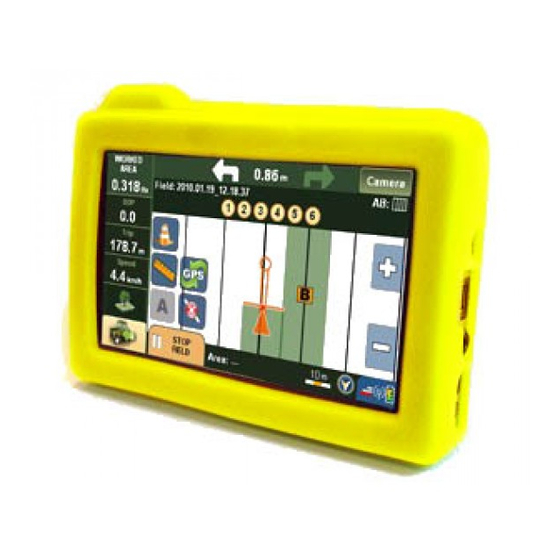
Page 7: Farmnavigator Main Menu
Road Navigation button, that brings you back to the road navigation main menu. From the field view you can open the Farmnavigator menu by clicking the button with the tractor icon in the bottom left corner of the screen. AvMap - 7... -
Page 8: Fields
The spray boom virtual control function can be used to control sprayers but also other machines such as Spreaders and Planters that work in a similar way. You can find the Spray Boom button also in the Settings menu. 8 - AvMap... -
Page 9: Farmnavigator Settings
To go back to the main menu, press the Back button in the upper left corner. 2.3.1 Working Width Here you can set the working width of your farm machine. This value is used to calculate the distance between AvMap - 9... -
Page 10: Spray Boom
Here you can select from four different types of navigation (par. 3.5). 2.3.4 Offset This setting allows you to move the position of your GPS receiver virtually forward and backwards (to the position of your sprayer), to have more accuracy in work. 10 - AvMap... -
Page 11: Area Unit
GPS position. 2.3.7 General settings In this menu the basic settings of the device, like language or display settings can be changed. For more info about device general settings, please read the full road navigation manual. AvMap - 11... -
Page 12: Camera
2.6 Bluetooth The Farmnavigator also offers a hand-free calls function for Bluetooth phones. Please read the full road navigation menu to get instructions on how to pair your mobile phone with the Farmnavigator. 12 - AvMap... -
Page 13: Creating And Working A Field
2. Press the Farmnavigator Settings button 3. Press the Working Width button 4. Use the left and right arrows to set the desired width 5. Press Accept to confirm Please read par. 2.3 for the other settings. AvMap - 13... -
Page 14: Measuring Perimeter And Area
(red arrow). Now drive around the field until you have reached the starting point, and then click the measure button again. The Field limits are now saved and the area is calculated. This information is stored in 14 - AvMap... -
Page 15: Positioning Obstacles / Soil Samples
3.5 Setting the Guide lines Once you have created the field, you can go on with your work using the Assisted-Driving function (a.k.a parallel guidance). The recording of field perimeter and the reference line can be done in one step. AvMap - 15... -
Page 16: Parallel Guide Lines
6. Press Field view in the upper right corner 3.5.1 Parallel guide lines Parallel guide lines are ideal for fields with straight boundaries. When driving the first reference line, set the point A at the beginning of the track by pressing the 16 - AvMap... -
Page 17: Contour Guide Lines
B. The Farmnavigator will record each position and draw the exact driven line and the corresponding parallel lines at the distance previously set as working width or virtual spray boom width. 3.5.3 Tram lines AvMap - 17... -
Page 18: Tram Lines
After the Guiding lines have been set, the navigation aid is displayed above the Map. The navigation aid shows with two directional arrows in which direction the steering has to be corrected to drive on the calculated 18 - AvMap... -
Page 19: Using The Spray Boom Virtual Control
When spreading chemicals on a field it is very important to control the treated area and to avoid treating twice the same portion of AvMap - 19... - Page 20 The Sections are displayed by numbered squares. You can select each section and change its width by clicking the modify size button. Use the arrows to adjust the number of booms and confirm with OK to save the settings and 20 - AvMap...
- Page 21 Yellow means that the spray boom can be open, red means that the section is overlapping an area that has already been treated so the operator should turn it off. To open the field database, go to the Farmnavigator AvMap - 21...
-
Page 22: Fields Database
Edit Name: After a field has been created, it is named automatically with the data of creation. This option allows you to rename the field to your wishes. Clear Obstacles: If you recorded obstacles or soil samples 22 - AvMap... -
Page 23: Exporting Field Data To Google Earth
4.2 Exporting field data to Google Earth You can export each field created and worked with the G6 Farmnavigator and view it on Google Earth. 1. Open the Field Database, select the field you want to export and open it pressing Open Selected. WARNING: in order to be able to export a field, this has to be open. - Page 24 Earth. These files will be saved in the Farmnavigator’s SD memory, inside the Fields folder. 3. Connect G6 Farmnavigator to the PC with the USB cable provided, without feeding it, the USB image will appear on the navigator’s display. The PC will read G6 Farmnavigator as an external memory support and the “removable disc”...
- Page 25 Earth for free from http://earth.google.com/). It will be possible to see on the Google Earth map the field’s perimeter marked with a coloured line, and the obstacles saved on the field. The Places window shows all the data relative to the field (area and obstacles positions). Click on the Fields AvMap - 25...
- Page 26 Farmnavigator name or on the Info icon to view more data about the work on the field (duration of the work, maximum DOP, working width settings, etc ). 4.3 Printing the field map from Google Earth 26 - AvMap...
-
Page 27: Printing The Field Map From Google Earth
1. To export the files, follow the procedure described in par. 4.2, up to step 4. 2. To import the file please connect the G6 Farmnavigator in which you want to import the data to the PC with the USB cable provided. Do not feed the navigator. The USB... - Page 28 The PC will read G6 Farmnavigator a san external memory support and the “removable disc” window will automatically pop 3. Copy and Paste inside the Fields / Import folder of G6 Farmnavigator (removable disc) the *.Kmz files previously copied on the PC 4.
-
Page 29: Appendix A: The Dop
It is important to know the DOP value in every moment as this information helps you to understand how much you can trust the precision of the GPS in that moment. If the DOP is bad then you could consider to wait until the DOP gets better to start the work. AvMap - 29... - Page 30 The Farmnavigator is only working if DOP is better 2.0. If DOP is above 2.0 Farmnavigator will stop do to on to bad Sat constellation SATCONSYSTEM Bundesstr. 7 AvMap USA 97531 Obertheres Germany 133 Falmouth Road Tel.: +49 (0) 9521/7072 Mashpee Fax: +49 (0) 9521/1350 MA 02649 www.farmnavigator.com info@satconsystem.de info@avmap.us 30 - AvMap...
- Page 32 www.farmnavigator.com...